
Image: 1941governatoratodalmazia
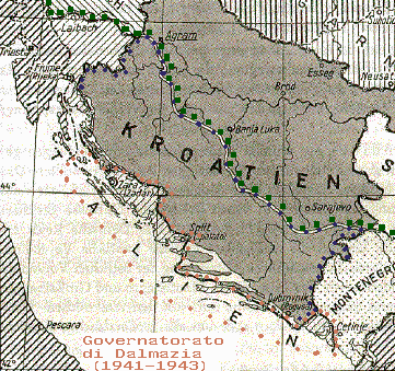
Description: Map of the "Governatorato di Dalmazia" (1941-1943), showing within orange points the borders. Within blue points are the limits of the area of Axis Independent State of Croatia in the Italian sphere of interest, further divided in two zones. Since the Treaties of Rome 1941, Italian Army initially had official status of "Besatzungs"-forces (not "Besetzungs-", occupational forces); later Italy occupied those areas, especially Second Zone remained under Italian occupation. It was proposed by Mussolini in 1942 for these areas to be annexed to the "Governatorato di Dalmazia". The green points show the limits of the Italian control, between 1941 and 1943, within defeated Kingdom of Yugoslavia. The basic map is taken from a German map of 1943 (Karte von Sudesteuropa/General Karte von Mitteleuropa 1:200.000)
Title: 1941governatoratodalmazia
Credit: Own work
Author: Brunodambrosio
Usage Terms: Public domain
License: Public domain
Attribution Required?: No
Image usage
The following page links to this image:
