
Image: A Map of Part of the Inland Country to the North West of Prince of Wales Fort Hudon's, Bay Samuel Hearne 1772 (1969)

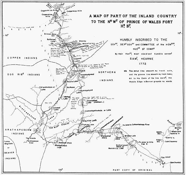
Description: The following is the author's description of the photograph quoted directly from the photograph's Flickr page. "Hearne, Samuel. A Map of Part of the Inland Country to the Nh Wt of Prince of Wales Fort Hs, By, Humbly Inscribed to The Govnr, Depy Govnr and Committee of the Honble, Hudns By Compy By their Honrs, most obedient humble servant Saml, Hearne 1772 [facsimile]. [1:3,801,600]. In: John Warkentin and Richard I. Ruggles. Manitoba Historical Atlas : a Selection of Facsimile Maps, Plans, and Sketches from 1612 to 1969. Winnipeg: Historical and Scientific Society of Manitoba, 1772, p. 92. As reproduced by, Winnipeg: Historical and Scientific Society of Manitoba. Churchill Fort at the mouth of the Churchill River, in what is now the Province of Manitoba, was the commencement point for Hudson%u2019s Bay Company exploratory-trade activity across the Barren Grounds, and the collection centre for information on this region. This map, prepared by Samuel Hearne, a young employee of the Company, in 1772, represents the culmination of the effort of Moses Norton, Factor at this post, to gain a more precise understanding of the geography of the country inland, and to encourage peace between its Indian and Eskimo inhabitants, thereby encouraging the expansion of peaceful trade. The map presents in detail, and with considerable precision, many of the water features between Churchill and Coppermine rivers, which were previously sketched in roughly and simply by Indians as shown in the three preceding maps. Except for the delineation of the ocean shore, the map does not show much of Manitoba territory. The tree line is indicated by a dotted line. (Warkentin and Ruggles. Historical Atlas of Manitoba. map 35, p. 92) Map prepared in black ink by R.I. Ruggles, from original manuscript (map G. 2/10) in the Archives, Hudson's Bay Company, London. Manuscript map in black ink with coloured portions on medium weight paper. Drawn by Samuel Hearne. "
Title: A Map of Part of the Inland Country to the North West of Prince of Wales Fort Hudon's, Bay Samuel Hearne 1772 (1969)
Credit: originally posted to Flickr as A Map of Part of the Inland Country to the Nh Wt of Prince of Wales Fort Hs, By Samuel Hearne 1772 (1969) Uploaded using F2ComButton
Author: w:Samuel Hearne, flickr upload by [1]
Permission: This file is licensed under the Creative Commons Attribution 2.0 Generic license. You are free: to share – to copy, distribute and transmit the work to remix – to adapt the work Under the following conditions: attribution – You must give appropriate credit, provide a link to the license, and indicate if changes were made. You may do so in any reasonable manner, but not in any way that suggests the licensor endorses you or your use. https://creativecommons.org/licenses/by/2.0 CC BY 2.0 Creative Commons Attribution 2.0 truetrue This image was originally posted to Flickr by Manitoba Historical Maps at https://www.flickr.com/photos/11496488@N07/2105762751. It was reviewed on 23 November 2009 by FlickreviewR and was confirmed to be licensed under the terms of the cc-by-2.0. 23 November 2009
Usage Terms: Creative Commons Attribution 2.0
License: CC BY 2.0
License Link: https://creativecommons.org/licenses/by/2.0
Attribution Required?: Yes
Image usage
The following page links to this image:

.jpg)