
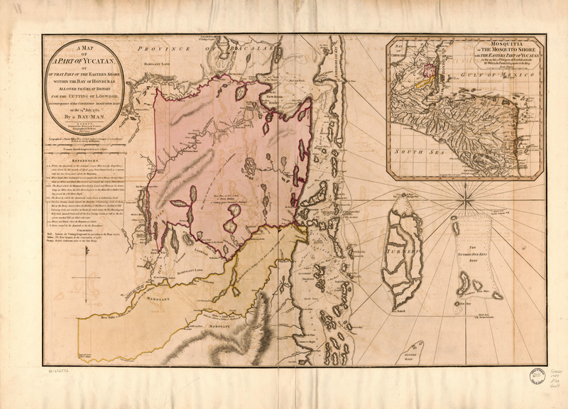
Image: A map of a part of Yucatan, or of that part of the eastern shore within the Bay of Honduras alloted to Great Britain for the cutting of logwood, in consequence of the convention signed with Spain on LOC 86692592
Description: Covers Belize. Relief shown by hachures. Depths shown by soundings. Includes descriptive index and inset of "Mosquitia or the Mosquito Shore with the eastern part of Yucatan as far as the 20th degree of north latitude," ca. 1:5,300,000. Available also through the Library of Congress Web site as a raster image. Vault
Title: A map of a part of Yucatan, or of that part of the eastern shore within the Bay of Honduras alloted to Great Britain for the cutting of logwood, in consequence of the convention signed with Spain on LOC 86692592
Credit: https://www.loc.gov/item/86692592/
Author: Faden, William
Permission: This map is available from the United States Library of Congress's Geography & Map Division under the digital ID g4820.ct008409. This tag does not indicate the copyright status of the attached work. A normal copyright tag is still required. See Commons:Licensing.
Usage Terms: Public domain
License: Public domain
Attribution Required?: No
Image usage
The following page links to this image:
