
Maya Mountains facts for kids
Quick facts for kids Maya Mountains |
|
|---|---|
| Montañas mayas | |

Maya Mountains during clear conditions / 2012 photograph by E. xxx / via Flickr
|
|
| Highest point | |
| Peak | Doyle's Delight |
| Elevation | 3,688 ft (1,124 m) 1 |
| Dimensions | |
| Length | 70 mi (110 km) northeast |
| Width | 40 mi (64 km) southeast |
| Area | 1,970 sq mi (5,100 km2) |
| Geography | |

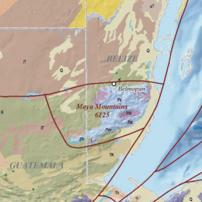
Location in Belize
|
|
| Countries | southwestern Belize and northeastern Guatemala |
| Districts | Cayo, Stann Creek, Toledo, Peten |
| Range coordinates | 16°53′58″N 88°40′18″W / 16.899443741204585°N 88.67161109755861°W |
| Geology | |
| Age of rock | Palaeozoic–Cenozoic3 |
| Type of rock |
|
| Volcanic arc/belt | Bladen Formation3 |
| Last eruption | c. 410 Ma3 |
| 1 Per / 2 Per / 3 Per | |
The Maya Mountains are a mountain range found in Belize and eastern Guatemala, in Central America. These mountains are an important natural area.
Contents
What's in a Name?
The Maya Mountains were once called the Cockscomb or Coxcomb Mountains. This name was used until the middle of the 20th century. Today, they are known as the Maya Mountains. This name honors the ancient Maya people.
Exploring the Maya Mountains

Physical Features
Tallest Peaks
The highest points in the Maya Mountains are Doyle's Delight and Victoria Peak. Doyle's Delight stands at about 3,688 feet (1,124 meters) tall. Victoria Peak is almost as high, reaching about 3,680 feet (1,122 meters).
Rivers and Waterways
Many rivers flow from these mountains into the Caribbean Sea. Nine important streams start here. These include parts of the Belize River, Monkey River, Sittee River, and Boom Creek.
Caves and Karst
The mountains have cool features like the Chiquibul Spring and Cave System. This area also has the Vaca Plateau. These are examples of "karst" landscapes. Karst means the land is shaped by dissolving bedrock, often creating caves and sinkholes.
Special Rocks
The Maya Mountains are the only place in Belize with certain types of rocks. These include igneous and metamorphic rocks. They are found in three main areas: Mountain Pine Ridge, Hummingbird Ridge, and the Cockscomb Basin. Ancient stonemasons might have used rocks from Mountain Pine Ridge. They used them to make tools like grinding stones.
Climate and Rain
The amount of rain changes across the mountains. In the northwest, it rains about 98 inches (2,500 mm) each year. In the southeast, it rains less, about 59 inches (1,500 mm) per year.
Human Impact and Protection
Protected Parks
A large part of the Maya Mountains is protected. There are seventeen parks, reserves, sanctuaries, and monuments. These protected areas are in southern Belize and northern Guatemala. They help keep the natural environment safe.
| WDPA ID | Name | Type | District | Notes |
|---|---|---|---|---|
| 3306 | Chiquibul | forest reserve | Cayo | – |
| 3314 | Columbia River | forest reserve | Toledo | – |
| 3311 | Deep River | forest reserve | Toledo | – |
| 28850 | Maya Mountain | forest reserve | Stann Creek | – |
| 3305 | Mountain Pine Ridge | forest reserve | Cayo | – |
| 3307 | Sibun River | forest reserve | Cayo | – |
| 12229 | Sittee River | forest reserve | Stann Creek | – |
| 116297 | Vaca | forest reserve | Cayo | – |
| 301932 | Noj Kaax Me'en Eligio Panti | national park | Cayo | – |
| 20230 | Chiquibul | national park | Cayo | – |
| 12241 | Bladen | nature reserve | Toledo | – |
| 10579 | Cockscomb Basin | wildlife sanctuary | Stann Creek | – |
| 20229 | Caracol | archaeological reserve | Cayo | – |
| 301918 | Victoria Peak | natural monument | Stann Creek | – |
| 30614 | Montañas Mayas Chiquibul | nature reserve | Peten | – |
| 30618 | San Román | nature reserve | Peten | – |
| 902858 | Yaxhá-Nakum-Naranjo | national park | Peten | – |
Environmental Challenges
The protected areas face some challenges. Sometimes, people from Guatemala illegally farm or take resources from the land. This can harm the forests and wildlife. For example, many acres of forest have been cleared for farming. This breaks up the important forest areas. Also, illegal hunting can reduce animal populations. The white-lipped peccary, a type of wild pig, has almost disappeared from some areas.
There are also challenges within Belize. More people living in the area can put pressure on the environment. For instance, a dam called the Chalillo Dam was built in the mountains. This caused some controversy. It flooded about 2,400 acres of forest and river areas. It also led to pollution in nearby villages.
How the Mountains Formed
| Maya Mountains | |
|---|---|
Maya Mountains / in 2006 map by French & Schenk / via USGS
|
|
| Location | central Belize, northeastern Guatemala |
| Part of | Maya Block |
| Length | 95 mi (153 km)1 |
| Width | 65 mi (105 km)1 |
| Area | 4,470 sq mi (11,600 km2)1 |
| Geology |
|
| USGS geologic province number | 6125 |
| 1 As per and maps. | |
The Maya Mountains are a special geological area. They are part of the Maya Block on the North American Plate. The mountains are made of very old rocks. These rocks include granite and sedimentary rocks from the Paleozoic era.
Ancient History
Maya Settlements
For a long time, not many people lived in the Maya Mountains. They were quite isolated. But between 600 and 830 CE, during the Late Classic period, more people moved there. The population likely reached its highest point in the 8th century. Around 830 CE, during the Classic Maya Collapse, many settlements became less populated. This led to fewer people living there during the Postclassic period.
The Maya Mountains and nearby areas have many important ancient Maya ruins. These include sites like Lubaantun, Nim Li Punit, Cahal Pech, and Chaa Creek.
Protecting Nature and History
Conservation in Belize
Efforts to protect nature in Belize started long ago. In 1817, a rule was made to control mahogany logging. But this rule didn't work very well. Later, in 1894, laws were passed to protect ancient artifacts. These laws were made stronger over the years.
In 1952, Alexander Hamilton Anderson was put in charge of archaeological work. This led to the creation of the Department of Archaeology in 1954. This department helps protect ancient Maya sites. Efforts to protect nature also grew. A Department of Forestry was set up in 1922. Laws were passed to protect plants and animals. In 1920, Silk Grass and Mountain Pine Ridge became "forest reserves." These were the first protected natural areas in Belize.
Conservation in Guatemala
Guatemala also started its conservation efforts early. Laws were passed in 1921 and 1945 to protect forests. This led to the creation of the country's first national parks in 1955. These were Atitlán and Rio Dulce National Parks.
Studying the Mountains
Early Explorations
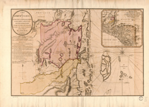
The first known journey into the Maya Mountains happened in 1787. Captains Samuel Harrison and Valentín Delgado led this trip. They were sent to find the source of the Sibun River. This was to figure out the borders of the British settlement.
Many other explorers followed them. These included Henry Fowler in 1879 and Karl Sapper from 1886 to 1935. Sapper's trips were the first geological expeditions into the mountains. L. H. Ower's survey from 1922 to 1926 created the first geological map of the area. These explorations helped us learn a lot about the Maya Mountains.
See also
- Mountain ranges of Central America
 In Spanish: Montes Maya para niños
