
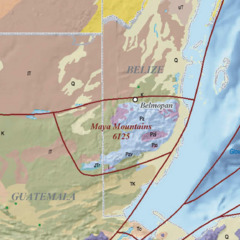
Image: Maya Mountains USGS OF-97-470-L 1-3

Size of this JPG preview of this TIF file: 600 × 600 pixels. Other resolution: 240 × 240 pixels.
Original image (1,153 × 1,153 pixels, file size: 9 MB, MIME type: image/tiff)
Description: Title: Map showing geology, oil and gas fields, and geologic provinces of the Gulf of Mexico region Author(s): French, C.D., and Schenk, C.J. Publishing Organization: U.S. Geological Survey Series and Number: Open-File Report OF-97-470-L Publication Date: 2006 Map Scale: 1:4,700,000 Cross Section: None North Latitude: 34° 0' 0" N (34.0000) South Latitude: 14° 0' 0" N (14.0000) East Longitude: 79° 0' 0" W (-79.0000) West Longitude: 103° 0' 0" W (-103.0000)
Title: Maya Mountains USGS OF-97-470-L 1-3
Credit: https://ngmdb.usgs.gov/Prodesc/proddesc_77647.htm
Author: French, C.D., and Schenk, C.J
Usage Terms: Public domain
License: Public domain
Attribution Required?: No
Image usage
The following page links to this image:

All content from Kiddle encyclopedia articles (including the article images and facts) can be freely used under Attribution-ShareAlike license, unless stated otherwise.