
All content from Kiddle encyclopedia articles (including the article images and facts) can be freely used under Attribution-ShareAlike license, unless stated otherwise.
 |
|

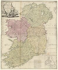
Description: Sujet : Irlande, Île d' Couverture : Irlande Langue : anglais Éditeur : J. Bowles and C. Bowles (London)
Title: A new and complete Map of the kingdom of Ireland, drawn from all the surveys and improvements which have hitherto been made ...
Credit: Bibliothèque nationale de France
Permission: This image from the Bibliothèque nationale de France (BnF) is a reproduction by scanning of a bidimensional work that is now in the public domain (). For this reason, it is in the public domain. This image can also be seen on Gallica: Image btv1b53029317m.
Usage Terms: Public domain
License: Public domain
Attribution Required?: No
The following page links to this image: