
Image: Airmountains tmo 2013145

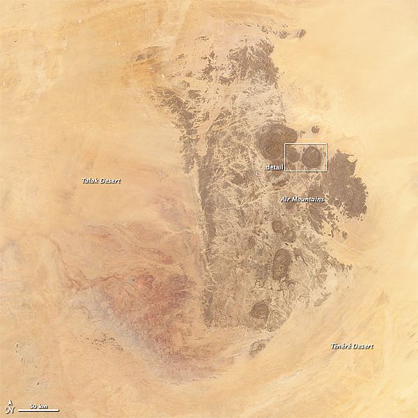
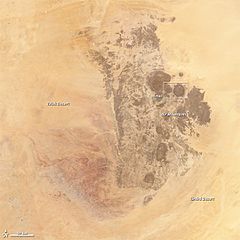
Description: The dark round domes of the Aïr Mountains rise out of the Sahara Desert, a chain of islands in a sea of sand. Geologically, the mountain massif in Niger is not that different from an island. It formed when magma flowed in to pre-existing cracks and caverns in the bedrock, a geologic formation called a dike. The bubble-shaped mounds are ring dikes, which formed when the ceiling of a magma chamber collapsed, leaving a circular crack that was later filled with magma. Through time and the constant movement of Earth's crust, these magma intrusions have been lifted and moved together, an isolated piece of geology different from its surroundings. The mountains are now 2,000 meters (7,000 feet) tall. These images show both the unique geology of the ring dikes and the relative isolation of the formation. The Operational Land Imager on the Landsat 8 satellite acquired the top image on May 26, 2013. Cracks cross the rock formation, a product of weathering and faulting. The Moderate Resolution Imaging Spectroradiometer (MODIS) on NASA’s Terra satellite acquired the lower image on May 25, 2013. This view provides wider context, showing how different the mountains are from their surroundings. (The formation looks even more isolated in this astronaut photo taken on March 23, 2010, just before a dust storm blanketed the mountains.) The Aïr Mountain Range is an ecological island too, supporting life naturally found in the African Sahel while being surrounded by the shifting sand dunes of the Sahara Desert. A wide variety of habitats—including dunes, stony deserts, cliff valleys and canyons, plateaus, and water holes—host 40 species of mammals, 165 species of birds, 18 species of reptiles, and 1 species of amphibian. The area provides prime habitat for three desert antelope species: the Dorcus gazelle, the Slender-horned gazelle, and the critically endangered Addax. In fact, part of the region is a sanctuary for the world’s largest population of wild Addax. The diversity found in the Aïr Mountains extends to plant life as well, with pockets of relict ecosystems that survive in few other places. Wild Sahelian plants include species of acacia and palms. Mediterranean plants like wild olives grow above 1,000 meters. The area also supports the wild relatives of common crops such as millet and sorghum. These native plants and animals have survived in the Aïr Mountains because they are mostly isolated from human inhabitants. Just 3,500 to 7,000 people live in the area, though Paleolithic and Neolithic archeological sites attest to the fact that people have long made the desert oasis home. In 1992, the site was inscribed as a World Heritage Site called the Aïr and Ténéré Natural Reserves. The site covers 7,736,000 hectares (30,000 square miles), making it the largest protected area in Africa. It covers both the Aïr Mountains and the plain of the Ténéré desert, which includes live, shifting sand dunes. References UNESCO Air and Ténéré Natural Reserves. Accessed October 10, 2013. Volcano World Air, Niger. Accessed October 10, 2013. Instrument: Landsat 8 - OLI
Title: Airmountains tmo 2013145
Credit: Aïr and Ténéré Natural Reserves
Author: NASA Earth Observatory images by Robert Simmon and Jesse Allen, using Landsat data from the USGS Earth Explorer and the LANCE/EOSDIS MODIS Rapid Response Team at NASA GSFC. Caption by Holli Riebeek.
Permission: Public domainPublic domainfalsefalse This file is in the public domain in the United States because it was solely created by NASA. NASA copyright policy states that "NASA material is not protected by copyright unless noted". (See Template:PD-USGov, NASA copyright policy page or JPL Image Use Policy.) Warnings: Use of NASA logos, insignia and emblems is restricted per U.S. law 14 CFR 1221. The NASA website hosts a large number of images from the Soviet/Russian space agency, and other non-American space agencies. These are not necessarily in the public domain. Materials based on Hubble Space Telescope data may be copyrighted if they are not explicitly produced by the STScI.[1] See also Template:PD-Hubble and Template:Cc-Hubble. The SOHO (ESA & NASA) joint project implies that all materials created by its probe are copyrighted and require permission for commercial non-educational use. [2] Images featured on the Astronomy Picture of the Day (APOD) web site may be copyrighted. [3] The National Space Science Data Center (NSSDC) site has been known to host copyrighted content. Its photo gallery FAQ states that all of the images in the photo gallery are in the public domain "Unless otherwise noted."
Usage Terms: Public domain
License: Public domain
Attribution Required?: No
Image usage
The following page links to this image:
