
Image: Albany plan 1695

Size of this preview: 503 × 599 pixels. Other resolutions: 201 × 240 pixels | 1,167 × 1,390 pixels.
Original image (1,167 × 1,390 pixels, file size: 820 KB, MIME type: image/png)
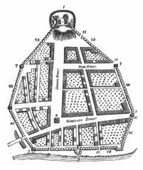
Description: Map of the city of Albany, New York, United States in 1695. Jonkers Street is the current State Street, Handlers Street is the current Broadway, and Pearl Street is still Pearl Street. Key: Fort of Albany Old Dutch Church Dutch Lutheran Church Burial ground Dutch burial ground Stadt Huys (City Hall) Block houses [Apparently not used] Great gun to clear a galley The Stockade Gates of the city (six total)
Title: Albany plan 1695
Credit: (1886, 1975) Albany's Bi-Centennial, John Papp Historical Publications, p. 14 ; the source of the engraving (the Miller Map) can be seen here.
Author: See source.
Usage Terms: Public domain
License: Public domain
Attribution Required?: No
Image usage
The following 3 pages link to this image:

All content from Kiddle encyclopedia articles (including the article images and facts) can be freely used under Attribution-ShareAlike license, unless stated otherwise.