
Streets of Albany, New York facts for kids
The streets of Albany, New York have a long and interesting history, going back almost 400 years! Many streets have changed names, sometimes many times. Some streets don't even exist anymore, while others have changed their path.
The very first streets were laid out without a clear plan. It wasn't until 1794 that Simeon De Witt created a proper grid plan for the city. This plan had two main sections: one for the area west of Eagle Street and the old stockade (a protective fence), and another for the Pastures District south of the stockade.
Contents
Albany's Oldest Streets
These streets began during the Dutch colonial times in the 1600s. Some, like Broadway, State, and Pearl streets, grew and stretched far into the countryside. Others, like Van Tromp, are very short, only one block long. Some are so narrow today that cars aren't allowed on them!
State Street: The Original Main Street
200 years apart one block from each other.


State Street was Albany's first "main street". It was originally called Yonker Street. State Street and Broadway are the two oldest streets in Albany.
Long ago, three buildings stood right in the middle of State Street: the first Dutch Reformed church, St. Peter's Anglican Church, and Fort Frederick. By 1810, all of these were taken down.
Today, State Street west of Eagle Street is sometimes called "upper" State Street. It's a one-way street going east. There are also other parts of State Street that are separated by buildings or parks.
Broadway: A Historic Path

On an old map from 1695, Broadway was called Handalaers Street. It was one of the first streets inside the Dutch stockade, making it one of Albany's oldest, along with State Street. The spot where Broadway meets State Street (then Yonker Street) was where the first Dutch Church stood until 1806.
North of State Street, Broadway was known as Market Street. The Quackenbush House, the second oldest house in Albany, was built along Broadway. Today, a small part of Broadway is still part of New York Route 5, though you won't see signs for it.
Pearl Street: Downtown's Core

Pearl Street is another very old Dutch street. Today, it's a big part of downtown Albany, full of places to eat, listen to music, and watch shows, like the Times Union Center and the Palace Theatre.
The corner of Pearl Street and State Street was once called Elm Street Corner. A famous Elm Tree stood there, planted by Philip Livingston, who signed the Declaration of Independence. South of State Street, Pearl Street was just a path to the common pastures, sometimes called "Cow Lane." After the Revolution, it was named Washington Street to honor George Washington. Later, it was split into North Pearl and South Pearl.
Pearl Street is part of NY Route 32 for much of its length.
Hudson Avenue: A Street Divided
Hudson Avenue was originally called Hudson Street. It ran along the southern edge of the old stockade. The oldest building in Albany, at 48 Hudson Avenue, was built when Hudson Street was just a small path outside the stockade.
When the huge Nelson A. Rockefeller Empire State Plaza was built, a large part of Hudson Avenue disappeared. Now, Hudson Avenue is split into four separate sections because of the Plaza, Washington Park, and the College of Saint Rose.
Maiden Lane and Pine Street: Parallel Paths
Maiden Lane and Pine Street are two streets that run side-by-side and have a shared history. Maiden Lane is older; it was called Rom Street and was one of the first streets inside the stockade. It was often used as a service road for buildings on State Street.
Pine Street was originally much shorter. In the 1970s, a big city project changed Maiden Lane. Pine Street was extended to take over the traffic that used to use Maiden Lane. Today, most of Maiden Lane is a pedestrian mall, meaning only people can walk there, not cars. The Hudson River Way bridge connects Maiden Lane to the Hudson River.
Clinton Avenue: A Dividing Line
Clinton Avenue was once called Patroon Street. It was named this because it marked the dividing line between the city of Albany to the south and the lands of the Van Rensselaers to the north. It was later renamed Clinton Avenue to honor DeWitt Clinton.
De Witt's Grid Plan

In the 1790s, Simeon De Witt created a new grid plan for Albany's future streets. For the area west of Eagle Street, he gave east-west streets names of mammals and north-south streets names of birds.
- Bird names (east to west): Eagle, Hawk, Swan, Dove, Lark, Swallow (now Knox and Henry Johnson Boulevard), Snipe (now Lexington Avenue), Duck (now Robin), Pigeon (now Lake Avenue), Turkey (now Quail), Sparrow (now Ontario), and Partridge.
- Mammal names (north to south): Hare (now Orange), Fox (now Sheridan Avenue), Elk, Lion (now Washington Avenue), Deer (now State), Tiger (now Lancaster), Buffaloe (now Hudson Avenue), Wolf (now Madison Avenue), Otter (now Elm), and Mink (now Myrtle).
Many of these streets already existed, but De Witt gave them new, animal-themed names. Over time, most of the mammal names changed again, often to match older downtown streets. Some bird names also changed, like Snipe to Lexington Avenue. Because of hills and swamps, some streets weren't built all the way through, leading to gaps.
Madison Avenue: From Wolf to US Route 20
Madison Avenue started as two separate streets in De Witt's plan: Lydius Street and Wolf Street. Eventually, they connected and became Lydius Street, which then took the name Madison Avenue.
Today, Madison Avenue from South Pearl Street westward is part of U.S. Route 20. It forms most of the northern border of the Mansion Historic District and has many important places along it, like Bleecker Park, the Cathedral of the Immaculate Conception, Empire State Plaza, New York State Museum, Washington Park, and the College of Saint Rose.
Washington Avenue: A Royal Road
Washington Avenue was originally called King Street until De Witt's plan, when it became Lion Street. It was the start of the "King's Highway," a series of paths leading to Schenectady.
Washington Avenue begins at Eagle Street and is part of New York Route 5 for a while. Many important buildings are located along Washington Avenue, including the New York State Capitol, the New York State Education Building, and the downtown and uptown campuses of SUNY Albany. Further west, Washington Avenue becomes Washington Avenue Extension, a four-lane highway with many businesses.
Lark Street: Midtown's Heartbeat

Lark Street is a very important street in Midtown Albany, especially for the Hudson/Park and Center Square neighborhoods. Like all the bird-named streets from De Witt's plan, Lark Street runs north and south.
Lark Street runs from Myrtle Avenue north to Clinton Avenue. Another section continues north to Manning Boulevard. From Madison Avenue to Clinton Avenue, Lark Street is part of US Route 9W.
Knox Street / Henry Johnson Boulevard
Swallow Street, another bird-named street, was changed to Knox Street in 1809. It stretched north from Myrtle Avenue. Later, parts of Knox Street were renamed Northern Boulevard.
In 1880, the section of Knox Street within Washington Park was bought and turned into a pedestrian mall called the Knox Street Mall. It's the only straight path in the park! In 1991, a large part of Northern Boulevard, including the section in Washington Park, was renamed Henry Johnson Boulevard to honor an African-American World War I hero.
Turnpikes: Roads with a Toll History

Starting in 1799 with the Great Western Turnpike, turnpikes began to spread out from Albany. These were roads built by private companies, and you had to pay a toll to use them. Over time, the city bought them, and they became regular city streets, often turning into state or US highways.
Central Avenue: Albany's Modern Main Street
Central Avenue was first called "the Bowery." It was the Albany end of old Native American trails that connected Albany to Schenectady. In 1802, the Albany and Schenectady Turnpike was built, following the path of the Bowery. In 1867, Albany changed the name to Central Avenue.
Central Avenue is also New York State Route 5. It's Albany's current main street, with lots of shops, restaurants, and car dealerships. The eastern part is more urban, with buildings close to the street, while the western part is more suburban with big parking lots.
Delaware Avenue: A Southern Connection
Delaware Avenue was originally called the Delaware Turnpike. It was built over an old Native American trail. The turnpike company stopped maintaining the road in 1868, and it became Delaware Avenue.
Delaware Avenue runs from Madison Avenue and Lark Street south to the city border. Important places along this road include Hackett Middle School, Lincoln Park, and a movie theater. Delaware Avenue is also part of US Route 9W for a section.
New Scotland Avenue: Colleges and Hospitals
A section of New Scotland Avenue was part of De Witt's original "bird-named" street, Snipe Street. Later, in 1850, a plank road (a road made of wooden planks) was built, which is now New Scotland Avenue.
Today, New Scotland Avenue is home to many colleges, hospitals, and businesses. You'll find Albany Medical Center, Albany Law School, Albany College of Pharmacy, and St. Peter's Hospital along this street.
Other Historic Streets
Melrose Avenue: Railroad History
This short street is in the Melrose neighborhood. It sits on the old path of the Mohawk and Hudson Railroad, which was the first railroad in New York State!
Manning Boulevard: A Parkway Idea
Manning Boulevard was first built in 1876. It was once called Northern Boulevard and also "Boulevard." It was proposed to be a large semicircular parkway around the city. The boulevard was named after Daniel Manning, a former park commissioner and a Secretary of the Treasury under President Grover Cleveland.
Manning Boulevard today extends in several sections. It's unusual because some houses along it are on separate frontage roads, with the main boulevard in the middle.
Southern Boulevard: Gateway to the South
Southern Boulevard is a major road that connects Albany to the Thruway (a big highway) and to the southern suburbs. Construction of Southern Boulevard was approved in 1913 and finished in 1916.
Southern Boulevard begins at Delaware Avenue, and US Route 9W joins it there. It continues southeast, passing over Interstate 787 and connecting to Interstate 87 (the Thruway) at Exit 23.
Numbered Streets and Avenues
Albany has three groups of numbered roads.
- In the South End, there are Second, Third, and Fourth avenues. Before 1873, they had different names.
- In Arbor Hill, there are Second and Third streets.
- In North Albany, there's another set of three streets.
Major Highways: Connecting Albany
Starting in the 1950s, Albany began to get several limited-access highways (roads with no traffic lights or cross-streets) to connect it with other cities. Some of these highways were planned but never fully built.
New York State Thruway: The Main Artery
Albany's part of the Thruway was built in 1952-1953. This highway connects Albany to other big cities like New York City, Syracuse, and Buffalo. In Albany, the northbound Thruway from downstate turns west.
The Thruway enters Albany from Bethlehem. Exit 23, one of the busiest exits, connects the Thruway to Southern Boulevard and Interstate 787. The Thruway then goes northwest, briefly leaving and re-entering the city. Exit 24, the busiest exit on the entire Thruway, is at the western end of Albany. Here, the Thruway changes from Interstate 87 to Interstate 90.
Interstate 90: Across the North Side
Interstate 90 enters Albany as part of the New York State Thruway. However, it soon becomes a separate six-lane freeway. This part of I-90 runs through the north side of Albany, near the border with Colonie.
I-90 provides access to SUNY Albany's Uptown Campus and the W. Averell Harriman State Office Building Campus. It also connects to U.S. Route 9 and finally meets Interstate 787 before crossing the Hudson River into Rensselaer County.
Interstate 787: Along the River
_from_the_overpass_for_the_ramp_to_Empire_Plaza_in_Albany,_Albany_County,_New_York.jpg)
Interstate 787 connects the Thruway with downtown Albany. It also links Albany to northern parts of Albany County, like Watervliet and Cohoes. The first part of I-787 was built in the 1960s. Several exits of I-787 are within the city of Albany.
Crosstown Arterial: Western Albany's Highway
The Crosstown Arterial, also known as New York State Route 85, is a four-lane highway that serves the western parts of Albany. It connects to Interstate 90. The highway has several exits that provide access to Washington Avenue, the State Office Campus, and Western Avenue.
Northway / Fuller Road Alternate
The Northway, which is part of Interstate 87 north of the Thruway, was built in sections starting in the late 1950s. It connects Albany to northern suburbs like Latham and Clifton Park, and even further north to places like Lake George and Montreal.
Fuller Road Alternate is a small part of this highway system that was originally planned to be part of a different expressway. Exit 1 of the Northway is the only exit within Albany, connecting to Interstate 90.
South Mall Arterial: Under the Plaza
The South Mall Arterial is a road that connects S. Swan Street with Interstate 787. A unique feature of this road is that it goes underneath the large Empire State Plaza.
Images for kids
-
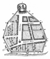
Map of Albany in 1695. North is to right.

