
Pastures Historic District facts for kids
Quick facts for kids |
|
|
Pastures Historic District
|
|

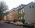
Houses on north side of Westerlo Street, 2008
|
|

Location in New York

Location in the United States
|
|
| Location | Albany, NY |
|---|---|
| Area | 17 acres (6.9 ha) |
| Built | early 19th century |
| Architectural style | Greek Revival |
| NRHP reference No. | 72000815 |
| Added to NRHP | 1972 |
The Pastures Historic District is a neighborhood in Albany, United States. It is south of the city's downtown area. This district covers about 17 acres (6.9 ha) and includes parts of 13 city blocks.
This area was once a shared pasture (a field for grazing animals). Albany's city council set it aside in the late 1600s. They later gave the land to the Dutch Reformed Church. As Albany grew, this land was divided into building lots. Many small rowhouses were built here.
Even today, many open spaces remain. The houses have not changed much over time. In 1972, the city made it a historic district. It was then added to the National Register of Historic Places. Almost all buildings in the district are considered historic.
The Pastures was a very busy neighborhood in the 1800s. But in the mid-1900s, people started moving to the suburbs. The area began to decline. Instead of tearing down buildings, the city tried to save and improve the area. This involved moving residents out and demolishing some buildings. This plan has been criticized by some. Today, the Pastures is a diverse and lively neighborhood once again.
Contents
Exploring the Pastures Historic District's Location
The Pastures Historic District is located south of the South Mall Expressway. This expressway connects the Dunn Memorial Bridge to the Empire State Plaza. The area is mostly flat, rising only a little from the Hudson River. This is different from the nearby Mansion Historic District, which is on a slope.
What Are the Boundaries of the District?
The district's borders are generally Madison Avenue to the north and South Ferry Street to the south. Dongan and Green streets are to the east. South Pearl Street (NY 32) is to the west. Streets like Bleeker, Franklin, Herkimer, John, South Lansing, and Westerlo are inside the district.
The exact boundary was made clear in 1984. It does not follow these streets perfectly. Some newer buildings and areas where buildings were torn down are not included. For example, no property directly on South Pearl Street is in the district. All properties on the south side of Madison Avenue are included. Also, properties on the west side of Green Street are part of it.
The entire block with the former St. John's Roman Catholic Church is included. The boundary then follows Dongan Street to South Ferry Street. It turns west along South Ferry Street. All properties on the north side of South Ferry are within the district.
What Kind of Buildings Are Here?
There are 112 buildings in this 17-acre (7 ha) area. Only two are not considered historic. Many buildings are rowhouses. They are built in the Federal and Greek Revival styles.
These buildings do not cover their entire lots. This leaves a lot of open space in the district. Some of this space is used for parking. Other parts are lawns or parks. There is also a tennis court on John Street.
The only non-residential buildings are three institutions. These include the former St. John's Church, its school, and a synagogue. School No. 15, which was the only school building, burned down in 1979. This happened during the city's efforts to improve the neighborhood.
A Look Back at the Pastures' History
The Pastures area became available for building after the United States became independent. However, it took some time to become a popular place to live. Most of its buildings were constructed between 1815 and 1855. Some were later torn down in the 1970s.
Early Days: 1600s and 1700s

The Dutch colonists founded Albany in the mid-1600s. They set aside this land as a common pasture. It was located outside the city's stockade (a protective fence). In 1687, Albany became an English colonial city. The city council then gave this land to the Dutch Reformed Church. The church owned the land for nearly a century, using it for grazing animals.
What is now South Pearl Street was the only path to this area. It was sometimes called "Cow Street" because cattle used it to go to graze. Simple homes were built along it after 1766. In 1783, George Washington supposedly used this street to visit the Schuyler Mansion. After that, it became known as Washington Street.
After the Revolutionary War, the city asked the church to divide the land into building lots. They wanted the church to sell these lots for development. This happened slowly, mostly along the main streets. The first people to settle here were often wealthy families. They built homes in the Federal style, which was popular at the time.
Growth in the 1800s

In 1808, Spencer Stafford, a successful merchant, built 100 Madison Avenue. This is the oldest building in the district. It is also one of the oldest in Albany. The house at 96 Madison, built three years later, was considered the most elegant home in the city. Four houses at 82–94 Madison were built in 1814. They were owned by Dudley Walsh, who founded Union College. People with less money also lived in the Pastures. This included tradesmen, craftsmen, and free African Americans.
Over the next 20 years, stone yards opened in the area. Middle-class people continued to move in. Carpenters and builders bought several lots. They built rows of houses, lived in one, and rented out the others. These houses, many still standing on South Ferry Street, added a third story, gabled roofs, and dormer windows to the neighborhood. Joseph C. Yates lived at 96 Madison when he was governor of New York.
As building continued into the 1830s and 1840s, houses showed a simpler Greek Revival style. They were mostly brick, often laid in Flemish bond. Plain pilasters (flat columns) were next to the entrances. There was little decoration on the front of the buildings. Newer roofing methods allowed for flat roofs. Some wooden stores were also built, but most have since been torn down.

The years around the Civil War were the last for large-scale building in the Pastures. The neighborhood was becoming full. Newer areas of the city were also available for building. Most new rowhouses replaced older wooden buildings. The houses at 51–55 Westerlo Street were a notable new group.
Mixed-use development also started to appear. New houses had shops on the first floor and living spaces above. Fancy storefronts can still be seen at 79 South Ferry and 104 Madison. Older houses also got updated looks. They added decorations like bracketed cornices and metal lintels. Some flat-roofed buildings had a third story added.
A few scattered houses from after this period exist. The detailed brickwork at 77 Westerlo, from 1886, stands out. On the other hand, 68 and 70 Westerlo show simpler styles from the early 1900s. The biggest change in this period was converting some homes on Madison west of Franklin into stores.
The 1900s and Beyond
In the early 1900s, a Roman Catholic Church and a synagogue were built. St. John's Church, with its Gothic Revival stone towers, was built at 140 Green Street in 1903. Its school was built next to it. The brick Beth El Jacob synagogue followed in 1907 at 76 Herkimer Street. The neighborhood was now complete.
The Pastures' storefronts became known for their jazz bars in the early 1900s. In 1940, 76 Westerlo Street became the newest historic building in the district. During World War II, the Pastures was a busy and diverse neighborhood.
In the 1950s, people started moving to the suburbs. The construction of Empire State Plaza in the 1960s also caused many residents to move. Central Albany, including the Pastures, began to decline. In the late 1960s, the city's Historic Resources Commission named the area the Pastures Preservation District. It was listed on the National Register in 1972.
The city recognized the area's history and importance. They had big plans to "revitalize" the neighborhood. They moved residents out, hoping it would be temporary. Some old buildings were torn down, and new ones were built in similar styles. Nearly half of the buildings were demolished. The rest were left empty without heat.
While the neighborhood was empty, the city looked for a developer to take on the whole area. People who wanted to buy and restore one or two houses were turned away. The empty buildings continued to decay. Some even caught fire, including the school.
By 1980, the city changed its plans. They looked for developers for whole blocks, not the entire neighborhood. Half of the new homes had to be rented to low-income families. Eventually, the Pastures was repopulated. However, some critics believe the damage to its character was already done. Urbanist Roberta Brandes Gratz wrote that the "real place ceased to exist" when residents were moved out. She felt the area looked "more like a sanitized suburban enclave."
The Pastures in the 2000s
By the early 2000s, the neighborhood was full again. The city's planning commissioner noted its "mix of incomes and occupations." Many homes were set aside as affordable housing. Small businesses also moved into the area. 96 Madison is now a bed and breakfast. Residents like that the area is walkable and close to downtown. Some even compare it to Greenwich Village.
The neighborhood faced another challenge related to redevelopment. In the early 2000s, a person named Aaron Dare was involved in issues with mortgage applications for properties in Albany. This included the Historic Pastures Village Apartments. He made it seem like his company had enough money to borrow from the Department of Housing and Urban Development (HUD). After the properties were purchased, he did not repay the loans. This caused HUD to take back the properties. He was investigated and arrested. In 2006, he admitted to his actions. Two years later, he was sentenced to prison and ordered to pay money back to those affected.
Images for kids
-
Houses on north side of Westerlo Street, 2008
-
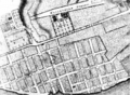
Street plan for the Pastures developed in 1794
-
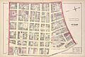
Map of Albany's 4th Ward in 1878. The Pastures was included in this ward.
-
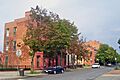
South Ferry from South Pearl
