North Albany, Albany, New York facts for kids
Quick facts for kids
North Albany
|
|
|---|---|
|
Neighborhood
|
|
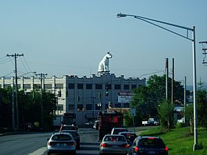
Nipper watching over North Albany,
as seen from Loudonville Road |
|
| Etymology: for its location north of the original Albany city limits |
|
| Nickname(s):
Limerick
|
|
| Country | United States |
| State | New York |
| County | Albany County |
| City | Albany |
| Settled | mid-1650s |
| Time zone | UTC-5 (Eastern Standard Time) |
| • Summer (DST) | UTC-4 (Eastern Daylight Time) |
| Area code | 518 |
| ZIP code | 12204, 12207 |
North Albany is a neighborhood in the city of Albany, New York. It was first settled in the mid-1600s. Early settlers included the Patroon (a Dutch landowner) of Rensselaerswyck and his tenants. Later, North Albany became a small community in the town of Watervliet.
A big change came in 1825 with the building of the Erie Canal. This led to huge growth for North Albany. It became home to the Albany Lumber District. Many Irish immigrants moved here, giving the area the nickname Limerick. Today, North Albany still has many old warehouses and row houses. It remains an important industrial area. Recently, old industrial buildings are being turned into fun places. These include a German beer garden, music venues, and arts markets.
Contents
History of North Albany
Early Settlement and Growth
The land that is now North Albany was once forests and farms. It was part of Rensselaerswyck, a large land grant from the Dutch. In 1654, people started renting a mill along the Patroon Creek. In 1666, the Patroon, Jeremias van Rensselaer, built a house and other buildings there. This area, north of Albany's original city limits, was called the colonie.
In 1825, the Erie Canal was built. This canal connected Albany to Buffalo on Lake Erie. Locks 1 and 2 of the canal were in North Albany. The canal helped create the Albany Lumber District. This area, once vegetable gardens, became a huge lumber market. For about 25 years in the mid-1800s, Albany was the biggest market for white pine lumber. By the 1870s, it was the largest lumber district in the US by value.
The canal also brought factories to North Albany. These factories made books, stoves, carriages, and tools. Many Irish immigrants who built the canal stayed to work in these factories. This is why the area earned its nickname, Limerick.
Roads and Annexation
In 1826, a company built the Watervliet Turnpike. This was a road where you paid a fee to use it. It ran north from Broadway through North Albany. Later, in 1862, this company also built a railroad along the road. Another important road was the Loudonville Plank Road (now Loudonville Road). It also had a toll gate.
By 1860, North Albany had about 40 houses. In 1870, North Albany officially became part of the city of Albany. It was called the Ninth Ward, and is now the Fourth Ward. Many streets were renamed in 1871. For example, North Pearl Avenue became North Pearl Street.
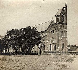
In 1876, the Sacred Heart Church was built for the large Irish Catholic community. In 1869, St. Peter's Hospital opened in North Albany. It had 33 beds and was staffed by the Sisters of Mercy. The hospital moved to a new location in 1930.
Electric streetcars began running in North Albany in 1889. This made it easier for people to travel.
North Albany After 1900
Around 1900, Albany built its first water filtration plant in North Albany. This helped provide clean water to the city.
Some of North Albany's old turnpikes remained important roads. North Pearl Street became part of New York Route 32 (NY 32) in 1930. Other state routes also passed through the area over time.
In 1950, North Albany held its first St. Patrick's Day Parade. This was one year before the citywide parade started. The neighborhood parade has almost never been canceled, even in heavy snow. However, both parades were canceled in 2020 due to the COVID-19 pandemic.
In 1953, the Edwin Corning Homes were built. These were public housing apartments for soldiers returning from World War II. They were named after Edwin Corning, a former Lieutenant Governor of New York.
During the 1960s, Albany's city landfill was located in North Albany. It closed for city waste in 1969. It continued to take construction waste until 1988.
The first female mail carrier in Albany started working in North Albany in 1970. She might have been the first in the whole Capital District.
In 2000, two professors found the first weigh lock of the Erie Canal during an archaeological dig. A weigh lock was used to weigh canal boats.
Modern Changes and Revitalization
In the 1990s and 2000s, North Albany began to change. Many old warehouses and factories were reused for new purposes. The city changed zoning rules in 1999. This allowed for sports stadiums, museums, hotels, and shops in areas that were once only for industry.
For example, a former fire station became a nightclub, then a music venue, and now a German beer garden called Wolff's Biergarten. A discount furniture store moved into an old paper mill. The former furniture store building became the Albany County Hall of Records in 2001. This building holds important historical documents like the original Dongan Charter. In 2007, an old brewery became "At The Warehouse," a weekend market for art, crafts, and food.
Sacred Heart Church also saw changes. In 1999, it became the first Catholic church in Albany led by a deacon instead of a priest. The church community also became more diverse. In 2006, the church's old convent was turned into apartments for veterans who had been homeless.
In 2001, the Corning Homes public housing was rebuilt into new townhomes. The name was changed to help residents feel more connected to the neighborhood.
In 2005, Public School No. 20 was renovated and renamed North Albany Academy. A YMCA (Y) was built next to the school. Students use the gym and pool during the day. The Y also has a library branch and a day care. This was the first Y in the US built using special tax breaks.
National Grid, a utility company, has its regional headquarters in North Albany. This site was once the Albany Gas Works, which made gas for street lamps. In 2010, National Grid opened a compressed natural gas station there. This helps reduce pollution from their trucks and is also open to the public.
Geography
North Albany is located between the railroad overpass on Broadway to the south and the city line with Menands to the north. It stretches from the Hudson River on the east to Van Rensselaer Boulevard on the west. The area has many older industrial sites along Broadway and North Pearl Street. Newer industrial businesses are found along Erie Boulevard.
 |
Town of Colonie Village of Menands |
 |
||
| Van Rensselaer Boulevard | Hudson River/Rensselaer County City of Rensselaer |
|||
| Arbor Hill |
Economy
North Albany has the largest industrial area in the city of Albany. It is also the most concentrated area for industry. About 75 industrial businesses are in the heart of North Albany. Most of these are small, but they provide around 2,000 jobs. Government offices, like the New York State Assembly's printing operations, are also here.
Both private groups and the city have worked to change North Albany. It is shifting from heavy industry to a "Warehouse District" with art and entertainment. Old warehouses and buildings are being reused. Besides the German beer garden and the arts market, an Irish pub opened in a former office showroom. A rock and roll and country music venue opened in an old bank building. These new places are all close to each other.
Transportation
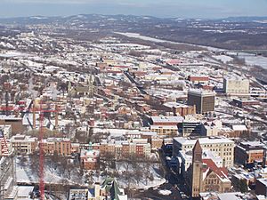
A railroad owned by CSXT runs along the southern edge of North Albany. This line is also used by Amtrak passenger trains. Another rail line, now owned by CP Rail, also goes through North Albany. There is a bulk transfer rail yard here.
North Albany's main streets are North Pearl Street and Broadway. They run north-south, connecting to Arbor Hill, Downtown, and Menands. Most other streets cross these main roads. North Pearl Street is also part of NY 32. Loudonville Road connects North Pearl Street and Broadway to other major roads. Van Rensselaer Boulevard forms the western border of North Albany. It leads north to Menands and the Albany Rural Cemetery.
Interstate 90 (I-90) cuts through the neighborhood. It connects with Interstate 787 (I-787) near the Hudson River. I-787 runs along the eastern edge of North Albany.
Landmarks
Nipper
Nipper is a giant, 24-foot tall dog statue in North Albany. He weighs 4 tons (3.6 metric tons)! Built in 1954, Nipper is a replica of the RCA mascot. He is the tallest known statue of the dog. Nipper has a warning light on his left ear for aircraft. You can see him from as far as 5 miles away.
Miss Albany Diner
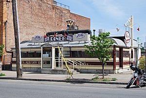
The Miss Albany Diner has been in North Albany since 1941. It was added to the National Register of Historic Places in 2000. Famous actors Jack Nicholson and Meryl Streep filmed scenes here for their movie Ironweed.
Central Warehouse
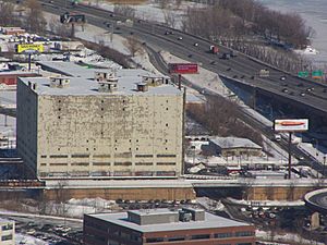
The Central Warehouse is a large refrigeration building in North Albany. It was built in 1927. It is a well-known landmark in the community. The building has been empty since the early 1990s. In 2010, a fire damaged the warehouse. In 2022, pieces of the wall fell near train tracks. This caused Amtrak to stop train service in the area until repairs were made.
Notable Residents
- Walter F. Doran (Retired Admiral) - He was a commander of the US Pacific Fleet.
- William Kennedy - A writer who won the Pulitzer Prize. He grew up in North Albany. Many of his novels, like Ironweed, feature the neighborhood.
- Jerry Jennings - He was the 74th mayor of Albany. He served for 20 years, making him the third-longest serving mayor.
 | Valerie Thomas |
 | Frederick McKinley Jones |
 | George Edward Alcorn Jr. |
 | Thomas Mensah |


