
Image: Ancient Near East 0900BC

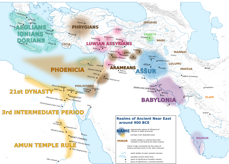
Description: Ancient Near East around 900 BCE: Syro-Hittites vs. Aramaeans / Assur vs. Babylon / 3rd intermediate of Egypt / Phoenician colonization Content of this map matches articles on the history of the pictured cities/empires/cultures, researched both on Wikipedia and independent map research. This is the English version of a German original with source documention here. To keep this work up to date with historical research, please contact me or discuss in the base map (documentation link) if there are discrepancies, errors or questions. The map is supposed to show approximate spheres of influence of the cultures and empires, in the period of the stated turn of the century. Exact borders are only rarely passed down, so there is a definite risk of uncertainty. The map also shows a selection of important settlements, again based on the stated turn of the century. Place names are, where possible, given in contemporary, transcribed form, sometimes with the [addition of the modern denominations] where contemporary names are out of use today. rivers are mostly showing their modern course. Modern water reservoirs were removed from view, though.
Title: Ancient Near East 0900BC
Credit: Own work
Author: Enyavar
Usage Terms: Creative Commons Attribution-Share Alike 4.0
License: CC BY-SA 4.0
License Link: https://creativecommons.org/licenses/by-sa/4.0
Attribution Required?: Yes
Image usage
The following page links to this image:
