
Image: Appendix to the Journals of the Senate and Assembly of the session of the Legislature of the State of California (1917) (14595348077)

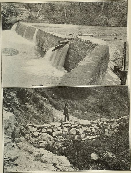
Description: Identifier: appendixtojourna19175cali (find matches) Title: Appendix to the Journals of the Senate and Assembly of the ... session of the Legislature of the State of California Year: 1853 (1850s) Authors: California. Legislature Subjects: Legislative journals Publisher: Sacramento : State Printing Contributing Library: San Francisco Public Library Digitizing Sponsor: San Francisco Public Library View Book Page: Book Viewer About This Book: Catalog Entry View All Images: All Images From Book Click here to view book online to see this illustration in context in a browseable online version of this book. Text Appearing Before Image: y alreadyfairly well saturated at the time of the high precipitation at the middleof January and the two days storm produced a rapid run-off from thesteep and rather thinly-timbered watersheds. The travel of the storm,west to east, being the same as the direction of the stream flow, tendsto large accumulation of water and sudden discharge. Whitewater and San Gorgonio rivers, Millard, Snow and Tahquizcreeks and Deep Canyon gave high discharge. The high water reachedto Palm Springs in the forenoon of January 17th, and receded towardsevening. The flood eroded a large channel, shown by PL VI, Fig. 1,across the valley along the Indio levee and overflowed, doing muchdamage to towns, farms and roads. The county highway was alsodamaged at many points all the way from Banning to Indio. It willbe noted from the map that this road follows near the stream channelalmost throughout this distance. Damage also occurred to farm prop-erty in the upper valley and at Palm Springs and the Rogers Ditch was Text Appearing After Image: Plate VII Fig 1 (upper).—Submerged dam on Santiago Creek. Fig. 2 (lower).—Rockche^k dam constiucted b/los Angeles County in Haines Canyon in experimental flood control. Bui. 4—(p. 21) FLOOD CONTROL IN COACHELLA VALLEY. 21 filled with sand for several miles. The Southern Pacific Company-suffered damage to track at the numerous stream crossings betweenBanning and Palm Springs Station and again from Indio to Thermal. Coachella Valley Storm Water District. The plans of the Indio Levee District, had they been carried out,might have safeguarded property at Indio, but they made no provisionfor protection of lower lands and the Coachella Storm Water Districtwas organized for the lower portion of the valley. It then becameapparent that the problem must be solved with respect to the bestinterests of the entire valley and the Coachella Valley Storm WaterDistrict was organized under the law of California, absorbing the twosmaller districts and embracing all valley land from Whitewater toSal Note About Images Please note that these images are extracted from scanned page images that may have been digitally enhanced for readability - coloration and appearance of these illustrations may not perfectly resemble the original work.
Title: Appendix to the Journals of the Senate and Assembly of the session of the Legislature of the State of California (1917) (14595348077)
Credit: https://www.flickr.com/photos/internetarchivebookimages/14595348077/ Source book page: https://archive.org/stream/appendixtojourna19175cali/appendixtojourna19175cali#page/n2005/mode/1up
Author: California. Legislature
Permission: At the time of upload, the image license was automatically confirmed using the Flickr API. For more information see Flickr API detail.
Usage Terms: No known copyright restrictions
License: No restrictions
License Link: https://www.flickr.com/commons/usage/
Attribution Required?: No
Image usage
The following page links to this image:

_(14595348077).jpg)