
Image: Austria-Hungary map new

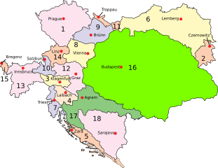
Description: Austria–Hungary: Empire of Austria (Cisleithania): 1. Bohemia, 2. Bukovina, 3. Carinthia, 4. Carniola, 5. Dalmatia, 6. Galicia, 7. Küstenland, 8. Lower Austria, 9. Moravia, 10. Salzburg, 11. Silesia, 12. Styria, 13. Tyrol, 14. Upper Austria, 15. Vorarlberg; Kingdom of Hungary (Transleithania): 16. Hungary proper 17. Croatia-Slavonia; Austrian-Hungarian Condominium: 18. Bosnia and Herzegovina
Title: Austria-Hungary map new
Credit: Austria-Hungary_map.svg
Author: Austria-Hungary_map.svg: IMeowbot
Permission: Public domainPublic domainfalsefalse This work has been released into the public domain by its author, IMeowbot at the Wikipedia project. This applies worldwide. In case this is not legally possible: IMeowbot grants anyone the right to use this work for any purpose, without any conditions, unless such conditions are required by law.
Usage Terms: Public domain
License: Public domain
Attribution Required?: No
Image usage
The following page links to this image:
