
Image: Battle of Mobile Bay map

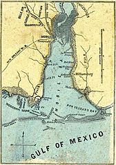
Description: Short Title: H.H. Lloyd & Co's Campaign Military Charts Showing The Principal Strategic Places Of Interest (map of Mobile Bay). Date: 1861. Author: Lloyd, H.H. ; Viele, Egbert L ; Haskins, Charles. Publisher: New York: H.H. Lloyd & Co. Format: File is in JPEG format, 10x-20x times faster than PNG-format files, due to auto-resizing as a smaller file (10-Feb-07). Full Title: H.H. Lloyd & Co's Campaign Military Charts Showing The Principal Strategic Places Of Interest. Engraved Expressly To Meet A Public Want During The Present War. Compiled From Official Data By Egbert L. Viele, Military and Civil Engineer; and Charles Haskins. Published Under The Auspices Of The American Geographical And Statistical Society. Entered ... 1861 by H.H. Lloyd & Co. H.H. Lloyd & Co's Military Charts. Sixteen Maps On One Sheet. Source: http://www.davidrumsey.com Variations: PNG-format file (same width 420x600, 10x larger file): :Image:Battle of Mobile Bay map.png (587 KB). Map labels (clockwise from top): Northern bay: Mobile River, Tensaw River, Appalacha River, D'Olive's Bay, Batteau Bay, Tensaw R., Levons B., Polecat Bay, Blakely I., Mobile R.; Eastern shore: Stockton, D'Olive's Bay, Howards Newport, Fish River, Red Bluffs, Alabama City, Williamsburg, GrPoint Clear, Mullet Point, Weeks' Bay, Fish R., Bon Secours R(iver); Bottom bay: Oyster Bay, Bon Secours Bay, Litle Pt Clear, St Andrews Bay, LT H, Ft. Morgan, Mobile Pt, Sand I(sland) / L.H., FT. Gaines, Pelican Bay, Dauphine I. Bay, Gravelines, Dauphine Island, Petit Bois I(sland), MISSISSIPPI SOUND; Western shore: Grand Bay, Terrapin., Grand Pt., Heron Bay, LT H, Cedar Pt, Alabama Port., Fowl R(iver), Fowl R Pt, Deer R(iver) Pt, Dog R(iver), New Orleans R.R. (railroad), Stewarts Pav, LT H, MOBILE, Mobile and Ohio R.R. (railroad), Gt Northern Rail Road, Toulminville, Whistler, Kushla, Belle Air.
Title: Battle of Mobile Bay map
Credit: Transferred from en.wikipedia to Commons by User:Undead_warrior using CommonsHelper.
Usage Terms: Public domain
License: Public domain
Attribution Required?: No
Image usage
The following 5 pages link to this image:
