Alabama Port, Alabama facts for kids
Quick facts for kids
Alabama Port, Alabama
|
|
|---|---|

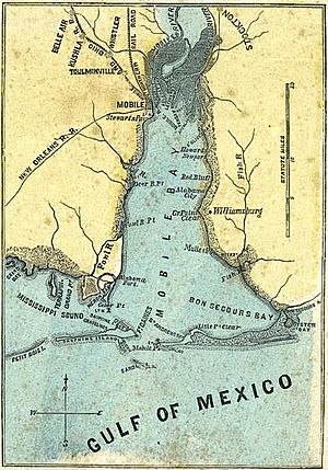
Map of Alabama Port on lower west side of Mobile Bay, 1861
|
|
| Country | United States |
| State | Alabama |
| County | Mobile |
| Elevation | 7 ft (2 m) |
| Time zone | UTC-6 (Central (CST)) |
| • Summer (DST) | UTC-5 (CDT) |
| Area code(s) | 251 |
Alabama Port, also known as Port Alabama, is a small community in Mobile County, Alabama, United States. It is an unincorporated community, which means it's a place where people live that isn't officially part of a city or town with its own local government. It is located on Mon Louis Island.
Where is Alabama Port?
Alabama Port is found on the western side of Mobile Bay. Its exact location is 30°26′26″N 88°06′21″W / 30.440474°N 88.105832°W. The land here is very low, only about 7 feet (2.1 meters) above sea level.
How Many People Live There?
Alabama Port has never been counted as a separate community in the official U.S. Census. However, in 1880, a part of Mobile County was called the "Alabama Port Precinct." A precinct is like a small area used for voting or counting people.
At that time, 417 people lived in the Alabama Port Precinct. Over the years, the name of this area changed several times. It was called Cedar Point in 1890, then Heron Bayou and Dauphin Island in 1900. From 1910 to 1920, it was just Heron Bayou, and from 1930 to 1950, it was called "Herron Bay." By 1960, this area became part of a larger census division called Bayou La Batre.
See also
 In Spanish: Alabama Port (Alabama) para niños
 | Kyle Baker |
 | Joseph Yoakum |
 | Laura Wheeler Waring |
 | Henry Ossawa Tanner |


