
Image: Battles of Charleroi and Mons map

Size of this preview: 795 × 599 pixels. Other resolutions: 319 × 240 pixels | 983 × 741 pixels.
Original image (983 × 741 pixels, file size: 32 KB, MIME type: image/png)
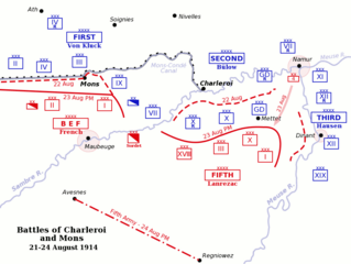
Description: Map of the Battles of Charleroi and Mons, southern Belgium, during the Battle of the Frontiers, 21-24 August, 1914. French, British and Belgian units are shown in red, German units are shown in blue. Fortress towns are marked with a shaded red circle.
Title: Battles of Charleroi and Mons map
Credit: originally uploaded by Gsl to English wikipedia.
Author: Gsl
Usage Terms: Public domain
License: Public domain
Attribution Required?: No
Image usage
The following 3 pages link to this image:

All content from Kiddle encyclopedia articles (including the article images and facts) can be freely used under Attribution-ShareAlike license, unless stated otherwise.