
Image: Bita paka location 1914
No higher resolution available.
Bita_paka_location_1914.jpg (350 × 384 pixels, file size: 109 KB, MIME type: image/jpeg)
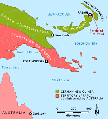
Description: Simple outline map of New Guinea and SW Pacific with political borders and nomenclature as prevailed in 1914 at the time of Battle of Bita Paka. Location of battle is highlighted.
Title: Bita paka location 1914
Credit: Transferred from en.wikipedia to Commons. (Original text : Own work Data sources: Coastlines: http://www.openstreetmap.org/?lat=-6.0040283203125&lon=154.9951171875&zoom=6, redrawn by mouse to suit purpose of map Nomenclature: )
Author: Chris Rees User:SpoolWhippets
Usage Terms: Creative Commons Attribution-Share Alike 3.0
License: CC BY-SA 3.0
License Link: https://creativecommons.org/licenses/by-sa/3.0
Attribution Required?: Yes
Image usage
The following page links to this image:

All content from Kiddle encyclopedia articles (including the article images and facts) can be freely used under Attribution-ShareAlike license, unless stated otherwise.