
History of Oceania facts for kids
The history of Oceania tells the story of the lands and people of Oceania, a huge region that includes Australia, Easter Island, Fiji, Hawaii, New Zealand, Papua New Guinea, and many other Pacific island nations. This history stretches back tens of thousands of years, from the first people arriving to the changes brought by European explorers and colonizers, and finally to the independent nations we see today.


Contents
- Ancient Times
- European Contact and Exploration (1500s–1700s)
- Colonization
- Samoan Crisis (1887–1889)
- World War I
- World War II
- Nuclear Testing in Oceania
- Fijian Coups
- Bougainville Civil War
- Modern Age
- See also
Ancient Times
The ancient history of Oceania is different for each main area: Australia, Melanesia, Micronesia, and Polynesia. People arrived in these places at very different times. Some parts, like Near Oceania (closer to Asia), were settled as early as 70,000 years ago. Other parts, like Remote Oceania (farther out in the Pacific), were settled much later, around 3,000 years ago.
Australia
Indigenous Australians are the first people who lived on the Australian continent and nearby islands. Their ancestors traveled from Africa to Asia about 70,000 years ago and reached Australia around 50,000 years ago. The Torres Strait Islanders are also Indigenous people who live in the islands north of Queensland.
The oldest human remains found in Australia are from Mungo Man, about 40,000 years old. There are many different Indigenous groups in Australia, each with their own unique cultures, customs, and languages.
Melanesia
The first people to settle Australia, New Guinea, and the large islands to the east arrived between 50,000 and 30,000 years ago. These were likely the ancestors of today's Papuan-speaking people. They came from Southeast Asia and spread as far east as the Solomon Islands.
About 3,000 years ago, Austronesian peoples arrived in the area, especially along the north coast of New Guinea and nearby islands. They came into contact with the Papuan-speaking people already living there. From this mix, a small group of Austronesian speakers continued eastward, becoming the ancestors of the Polynesians.

Recent genetic studies show that Polynesians and Micronesians are closely related to East Asians, like people from Taiwan. It seems their ancestors sailed quickly through Melanesia without mixing much genetically with the local people. Melanesian groups, however, show a lot of genetic diversity among themselves, which developed over tens of thousands of years.
Interestingly, some Melanesians have natural blond hair, even though they have dark skin. This is very rare outside of Europe.
Micronesia
Micronesia began to be settled thousands of years ago. It's hard to find old evidence because of the small size of the islands and storm damage. Most of what we know comes from studying languages. The earliest signs of human life were found on Saipan, dating back to about 1500 BCE.
The ancestors of the Micronesians arrived over 4,000 years ago. Over time, small chiefdoms grew into more organized societies, especially on Yap and Pohnpei.


On Pohnpei, an ancient ruling family called the Saudeleur dynasty built the amazing city of Nan Madol. This city, built from huge basalt logs, is made of many small artificial islands connected by canals. It's often called the "Venice of the Pacific." The Saudeleur rulers were powerful but became very strict. Their rule ended around 1628 when a foreigner named Isokelekel took over and created a more spread-out system of chiefs that still exists today.
The first people of the Northern Mariana Islands, called the Chamorros, arrived from Southeast Asia between 4000 BCE and 2000 BCE. They built large stone pillars called Latte stone. Later, in the 1800s, the Carolinian people also settled in the Marianas. The Marshall Islands were settled by Micronesian colonists around 2000 BCE, who used special stick charts to navigate between islands.
Polynesia
The Polynesians are a group of sea-faring people whose ancestors came from the Malay Archipelago and originally from Taiwan. Between 3000 and 1000 BCE, people speaking Austronesian languages spread from Taiwan into Southeast Asia, then into Micronesia and Melanesia.
The most accepted idea about how Polynesians spread is called the "Express Train" model. It suggests a quick expansion from Taiwan, through the Philippines and Indonesia, then to Island Melanesia by 1400 BCE, and reaching western Polynesia around 900 BCE. This idea is supported by genetics, language, and archaeological findings.
Archaeologists have found clear signs of this journey. Around 1400 BCE, the "Lapita culture" appeared in the Bismarck Archipelago in Melanesia. These people were known for their unique pottery. They adapted to new foods like breadfruit as they moved. The easternmost Lapita sites found so far are in Samoa and Tonga, dating back to around 1000-900 BCE.
Within just a few centuries, the Lapita culture spread 6,000 kilometers eastward to Fiji, Tonga, and Samoa. This area became a gateway to the rest of Polynesia. Ancient Tongan stories say that the islands of 'Ata and Tongatapu were pulled from the ocean by the god Maui.

The "Tuʻi Tonga Empire" refers to the period from 1200 to 1500 CE when Tonga had a lot of influence across Oceania. While it wasn't a strict empire like those in Europe, Tonga had widespread cultural influence and trade with places like 'Uvea, Rotuma, Futuna, Samoa, and Niue.
Pottery found in Fiji shows that it was settled around 3500 to 1000 BCE. It's believed the Lapita people (ancestors of Polynesians) settled there first. Later, Melanesians arrived, and the unique Fijian culture developed, blending elements from both. Fiji's early history was marked by constant warfare and cannibalism between tribes, which kept European sailors away for a long time.

Early European visitors to Easter Island heard stories about the first settlers, led by a chief named Hotu Matuꞌa, who arrived in large canoes. These settlers were Polynesians. Scientists disagree on the exact date, with estimates ranging from 300-400 CE to as late as 1200 CE. A large palm tree, unique to Easter Island, became extinct because the early settlers cut down forests.
European Contact and Exploration (1500s–1700s)
Iberian Pioneers
Early Iberian Exploration


Europeans began exploring Oceania in the 1500s. Portuguese sailors reached the Moluccas, Timor, and parts of New Guinea between 1512 and 1526. In 1519, a Spanish expedition led by Ferdinand Magellan sailed around South America and entered the ocean he named "Pacific" on November 28, 1520. Magellan was later killed in the Philippines, but one of his ships, led by Juan Sebastián Elcano, completed the first circumnavigation (sailing around the world). This expedition reached the Philippines, the Mariana Islands, and other islands in Oceania.
Other Large Expeditions
From 1527 to 1595, other Spanish expeditions crossed the Pacific. They discovered the Marshall Islands, Palau, Tuvalu, the Marquesas Islands, the Solomon Islands, the Cook Islands, and the Admiralty Islands.
In 1565, Spanish navigator Andrés de Urdaneta found a way for ships to sail eastward from Asia back to the Americas. After this, the annual Manila galleons sailed between Mexico and the Philippines, creating the first trade route across the Pacific. This route, combined with Spanish ships in the Atlantic, formed one of the first global trade networks.
Later, Spanish explorers looking for a southern continent discovered the Pitcairn Islands and Vanuatu. They also sailed through the Torres Strait between Australia and New Guinea. In 1668, the Spanish started a colony on Guam as a stop for their ships.
Oceania During the Golden Age of Dutch Exploration

Early Dutch Exploration
The Dutch were the first non-native people to explore and map the coastlines of Australia, Tasmania, New Zealand, Tonga, Fiji, and Easter Island. The Dutch East India Company was a major force behind this "Golden Age" of Dutch exploration in the 1600s. Dutch navigators mapped almost three-quarters of Australia's coastline, except for the east coast.
Abel Tasman's Exploratory Voyages
Abel Tasman was the first known European explorer to reach Van Diemen's Land (now Tasmania) and New Zealand. He also sighted the Fiji islands. His maps helped create a better understanding of these regions.
On November 24, 1642, Abel Tasman saw the west coast of Tasmania and claimed it for the Netherlands. He then sailed east and on December 13, sighted New Zealand, becoming the first Europeans to see it. Tasman named it Staten Landt. When he tried to get water, his men were attacked by Māori in canoes, and four of his men were killed. Tasman named the bay "Murderers' Bay" (now Golden Bay). He continued north, but mistook Cook Strait for a bay. Two of his names for New Zealand places, Cape Maria van Diemen and Three Kings Islands, are still used today.
On his way back, Tasman found the Tongan islands in January 1643. He also passed the Fiji Islands, almost wrecking his ships on dangerous reefs. He mapped parts of Fiji before returning to New Guinea and then to Batavia (modern-day Jakarta) in June 1643. For over a century after Tasman's voyages, Europeans did not visit Tasmania and New Zealand again.
-
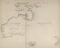
A map from the Golden Age of Dutch mapping, showing New Guinea, mainland Australia, Tasmania, and New Zealand.
-
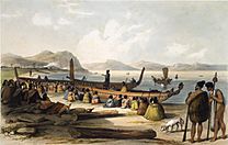
Waka taua (war canoes) at the Bay of Islands, 1827–1828.
-
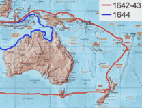
The route of Abel Tasman's first and second voyages.
-
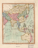
Australia (then called New Holland) shown as part of Asia in a 1796 map.
-
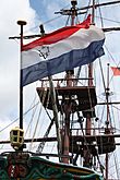
A replica of a Dutch East India Company ship.


- Map and drawings from Abel Tasman's voyages
-
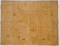
The Abel Tasman map from 1644.
-
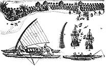
The first European drawing of Māori, at Murderers' Bay. Drawn by Isaack Gilsemans in Abel Tasman's travel journal (1642).
-
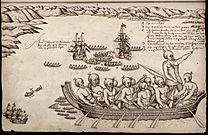
The bay of Tongatapu with Tasman's two ships, drawn by Isaack Gilsemans.


British Exploration and Captain James Cook's Voyages
First Voyage (1768–1771)


In 1766, the Royal Society sent James Cook to the Pacific Ocean to observe the planet Venus passing in front of the Sun. His expedition sailed from England on August 26, 1768, and reached Tahiti on April 13, 1769. After observing Venus, Cook opened secret orders to search for a large southern continent called Terra Australis.
With the help of a Tahitian navigator named Tupaia, Cook reached New Zealand on October 6, 1769. He was only the second European to do so after Abel Tasman. Cook mapped the entire New Zealand coastline, making only small mistakes. He also found Cook Strait, which separates the North and South Islands.
Cook then sailed west and reached the southeastern coast of Australia on April 19, 1770. His expedition was the first recorded European group to see Australia's eastern coastline. On April 29, Cook and his crew landed at what is now Kurnell Peninsula and met the Gweagal Aboriginal tribe.
After leaving Botany Bay, Cook continued north. After his ship got stuck on the Great Barrier Reef, he sailed through the Torres Strait and returned to England.

Second Voyage (1772–1775)

In 1772, the Royal Society asked Cook to search for Terra Australis again. On his first voyage, he had shown that New Zealand was not part of a larger southern landmass. Although he mapped most of Australia's eastern coast, people still believed a large continent lay further south.
Cook commanded the ship HMS Resolution on this voyage. His expedition sailed around the world very far south, becoming one of the first to cross the Antarctic Circle. In the Antarctic fog, his ships got separated. Cook continued exploring the Antarctic, reaching 71°10'S.
Cook almost reached the mainland of Antarctica but turned towards Tahiti to resupply. He then tried again to find the southern continent. On this trip, he brought a young Tahitian named Omai with him. On his way back to New Zealand in 1774, Cook landed at the Friendly Islands, Easter Island, Norfolk Island, New Caledonia, and Vanuatu.
When Cook returned to England, his reports finally ended the popular belief in Terra Australis.
Third Voyage (1776–1779)
On his last voyage, Cook again commanded HMS Resolution. The public believed the trip was to return Omai to Tahiti, but the main goal was to find a North-West Passage around North America. After dropping Omai off, Cook sailed north and in 1778 became the first European to visit the Hawaiian Islands. He named them the "Sandwich Islands."
From Hawaii, Cook sailed north and east to explore the west coast of North America, mapping the coast all the way to the Bering Strait. He filled in many gaps on world maps for this region.
Cook returned to Hawaii in 1779. His arrival happened during the Makahiki, a Hawaiian harvest festival for the god Lono. Some Hawaiians believed Cook was an incarnation of Lono because of the timing and the appearance of his ship.
After a month, Cook left Hawaii, but his ship's mast broke, forcing him to return to Kealakekua Bay for repairs. Tensions grew between the Europeans and Hawaiians. On February 14, 1779, some Hawaiians took one of Cook's small boats. Cook tried to take the Hawaiian King, Kalaniʻōpuʻu, hostage to get the boat back. The Hawaiians resisted, and Cook was killed in the fight. Four of his men also died.
The Hawaiians respected Cook and performed special funeral rituals for his body, usually reserved for chiefs. Some of his remains were later returned to his crew for a burial at sea. The expedition then returned to England in October 1780.

Colonization

British Colonization
In 1789, the famous Mutiny on the Bounty happened. Some of the mutineers settled on Pitcairn Islands, which later became a British colony. Britain also established colonies in Australia in 1788, New Zealand in 1840, and Fiji in 1872. Many parts of Oceania became part of the British Empire.
The Gilbert Islands (now Kiribati) and the Ellice Islands (now Tuvalu) came under British control in the late 1800s. They were managed as part of the British Western Pacific Territories.
Niue was one of the last islands in Oceania to be colonized. In 1887, King Fata-a-iki offered to join the British Empire, fearing other colonial powers. The British finally accepted in 1900, and Niue became a British protectorate. In 1901, New Zealand took over its administration.
French Colonization

French Catholic missionaries arrived in Tahiti in 1834. When they were expelled in 1836, France sent a warship. In 1842, Tahiti and Tahuata became a French protectorate, allowing missionaries to work freely. The capital of Papeetē was founded in 1843. In 1880, France officially took over Tahiti as a colony.
On September 24, 1853, France claimed New Caledonia, and the city of Nouméa was founded in 1854. New Caledonia became a penal colony, where France sent about 22,000 criminals and political prisoners between the 1860s and 1897.
In the 1880s, France also claimed the Tuamotu Archipelago and the Marquesas Islands. In 1889, France annexed Rimatara and Rūrutu after they failed to get British protection. The French colonies in Oceania were first called Établissements de l'Océanie (Settlements in Oceania), later changed to Établissements Français de l'Océanie (French Settlements in Oceania) in 1903.
Spanish Colonization
The Spanish explorer Alonso de Salazar landed in the Marshall Islands in 1529. These islands were later named after English explorer John Marshall, who visited them in 1788. Spain claimed the Marshall Islands in 1874.

In November 1770, a Spanish expedition from Peru landed on Isla de San Carlos (Easter Island) and signed a treaty to claim it with the Rapa Nui chiefs.
Dutch Colonization
In 1606, Luís Vaz de Torres explored the southern coast of New Guinea and claimed it for Spain. A later European claim came in 1828, when the Netherlands officially claimed the western half of the island as Dutch New Guinea.
.png)
In 1883, the British colony of Queensland annexed southeastern New Guinea. However, the British government took direct control in 1884 when Germany claimed northeastern New Guinea as German New Guinea.
The first Dutch government posts were set up in 1898 and 1902. German, Dutch, and British colonial leaders tried to stop inter-village warfare and headhunting in their areas.
In 1905, the British government gave some control of southeastern New Guinea to Australia, which renamed it "Territory of Papua" in 1906. During World War I, Australian forces took over German New Guinea. In 1920, it became the Territory of New Guinea, managed by Australia. These two Australian-controlled territories were known as The Territories of Papua and New Guinea until 1942.
German Colonization
Germany established colonies in German New Guinea in 1884 and German Samoa in 1900.
After an agreement with Spain, Germany claimed the Marshall Islands in 1885. Germany set up trading posts there for the copra (dried coconut meat) trade. Marshallese high chiefs continued to rule under German supervision.
American Colonization
The United States also expanded into the Pacific, starting with Baker Island and Howland Island in 1857. Hawaii became a U.S. territory in 1898. Disagreements between the US, Germany, and the UK over Samoa led to the Tripartite Convention of 1899.
Samoa joined the United States in 1904. This happened after the Tripartite Convention of 1899, which divided the Samoan Islands into American Samoa (for the US) and German Samoa (for Germany).
Japanese Colonization
At the start of World War I, Japan took control of the Marshall Islands. During World War II, Japan colonized many Oceanic islands by taking them from Western powers. On January 31, 1944, American forces landed on Kwajalein atoll and took control from the Japanese on February 3. In 1947, the United States agreed with the UN Security Council to manage much of Micronesia, including the Marshall Islands, as the Trust Territory of the Pacific Islands.
Samoan Crisis (1887–1889)


The Samoan Crisis was a tense situation between the United States, Germany, and Great Britain from 1887 to 1889. They were all trying to control the Samoan Islands during the Samoan Civil War.
In 1887, the prime minister of the Kingdom of Hawaii sent a ship to Samoa to try and form an alliance against colonial powers. This effort ended in embarrassment.
The crisis involved three American warships and three German warships facing each other in Apia harbor for several months. A British warship also watched the situation. The standoff ended suddenly on March 15 and 16, 1889, when a powerful cyclone destroyed all six warships in the harbor. Only the British warship, HMS Calliope, managed to escape.
The Samoan Civil War continued, involving Germany, the United States, and Britain. It eventually led to the division of the Samoan Islands into American Samoa and German Samoa in 1899.
World War I

The Asian and Pacific Theatre of World War I involved the conquest of German colonies in the Pacific Ocean and China. The biggest battle was the Siege of Tsingtao in China. Smaller battles happened at Battle of Bita Paka and Siege of Toma in German New Guinea.
All other German and Austrian possessions in Asia and the Pacific were taken without fighting. Naval battles were common, as colonial powers had navies in the Indian and Pacific Oceans. These fleets helped invade German territories and destroyed the German East Asia Squadron.
.jpg)
One of the first land attacks in the Pacific was the Occupation of German Samoa in August 1914 by New Zealand forces. Over 1,000 New Zealanders landed on the German colony, supported by Australian and French ships. The campaign ended without bloodshed.
Australian forces attacked German New Guinea in September 1914. About 500 Australians fought 300 Germans and local police at the Battle of Bita Paka. The Australians won, and the Germans retreated to Toma. Australian soldiers and a British warship surrounded the Germans, leading to their surrender.
After Toma fell, only small German forces remained in New Guinea, and they usually surrendered when met by Australian forces. German Micronesia, the Marianas, the Carolines, and the Marshall Islands also fell to Allied forces during the war.
World War II

The Pacific front saw major action during World War II, mainly between Japan and the United States.
The attack on Pearl Harbor was a surprise military strike by the Imperial Japanese Navy against the United States naval base at Pearl Harbor, Hawaii, on the morning of December 7, 1941. This attack led to the United States' entry into World War II.
Japan planned the attack to prevent the U.S. Pacific Fleet from stopping its military actions in Southeast Asia against British, Dutch, and U.S. territories. Japan also launched attacks on the Philippines, British Malaya, Singapore, and Hong Kong at the same time.
The Japanese then invaded New Guinea, the Solomon Islands, and other Pacific islands. The Japanese advance was stopped at the Battle of the Coral Sea and the Kokoda Track campaign before they were finally defeated in 1945.
Some of the most important battlegrounds in Oceania were the Solomon Islands campaign, the Air raids on Darwin, the Kokoda Track, and the Borneo campaign.
During World War II, many Polynesians served in the Free French Forces. Japan had plans to take over French Polynesia after the war, but they were never able to invade the islands.
.jpg)
_under_attack_and_burning_during_the_Battle_of_the_Eastern_Solomons_on_24_August_1942_(NH_97778).jpg)
Solomon Islands Campaign
Some of the most intense fighting of World War II happened in the Solomons. The Allies launched a major operation against the Japanese on August 7, 1942, with naval attacks and landings on Tulagi and Guadalcanal.
The Guadalcanal Campaign was a very important and bloody fight in the Pacific War as the Allies began to push back against Japanese expansion. People called "coastwatchers" played a key role. They were in remote places, often on Japanese-held islands, and gave early warnings about Japanese ship, troop, and aircraft movements.
"The Slot" was the nickname for New Georgia Sound, which the Japanese used to supply their troops on Guadalcanal. Of more than 36,000 Japanese soldiers on Guadalcanal, about 26,000 were killed or went missing, 9,000 died from disease, and 1,000 were captured.
.jpg)
Kokoda Track Campaign
The Kokoda Track campaign was a series of battles fought between July and November 1942 between Japanese and Allied (mainly Australian) forces in Papua, Australia. Japanese forces tried to advance south through the mountains to capture Port Moresby, aiming to cut off Australia from the United States.
At first, only a small number of Australian forces were available to stop them. The Japanese made quick progress, pushing the Australians back to Kokoda. The Australians fought off many Japanese attacks but had to retreat over the Owen Stanley Range along the Kokoda Track.
As the Japanese got close to Port Moresby, they started to lose momentum. The Australians received more troops, and the Japanese supply lines were stretched thin. Also, the Japanese suffered defeats at Guadalcanal. This marked the furthest point of the Japanese advance south. The Japanese then retreated to set up defenses on the north coast. The Australians followed and recaptured Kokoda on November 2. Fighting continued into November and December as Australian and U.S. forces attacked the Japanese beachheads in what became known as the Battle of Buna–Gona.
Nuclear Testing in Oceania

Because Oceania has a low population, it was often used for nuclear tests, both in the air and underground. The United Kingdom, the United States, and France conducted tests there, often with terrible effects on the local people.
From 1946 to 1958, the Marshall Islands were used by the United States for 67 nuclear tests. The world's first hydrogen bomb, called "Mike", was tested at the Enewetak atoll in the Marshall Islands on November 1, 1952.
In 1954, fallout from the American Castle Bravo hydrogen bomb test in the Marshall Islands was so bad that the people of the Rongelap Atoll had to leave their island. Three years later, they were allowed to return, but many suffered from high rates of cancer. They were evacuated again in 1985 and received $45 million in compensation in 1996.
The British also conducted tests in the 1950s at Maralinga in South Australia. This forced the Pitjantjatjara and Yankunytjatjara peoples to leave their ancestral lands.
In 1962, France chose the atoll of Moruroa in the Tuamotu Archipelago as its new nuclear testing site. Moruroa became famous because France continued tests there after most other Pacific testing had stopped. Many nations in Oceania opposed these tests. The last atmospheric test was in 1974, and the last underground test was in 1996.
French nuclear testing in the Pacific was very controversial in the 1980s. In 1985, French agents sank the Rainbow Warrior ship in Auckland to stop it from protesting at Moruroa. In September 1995, France caused widespread protests by restarting nuclear testing. The last test was on January 27, 1996. On January 29, 1996, France announced it would stop testing nuclear weapons.
Fijian Coups

Fiji has experienced several coups d'état (when the military or a group illegally takes control of the government). These happened in 1987, 2000, and 2006. They were mainly caused by tensions between indigenous Fijians and Indo-Fijians, whose ancestors came to the islands as laborers.
The 1987 coup happened after a multi-ethnic government was elected. Sitiveni Rabuka, a military officer, overthrew it, claiming discrimination against ethnic Fijians. The United Nations condemned the coup, and Fiji was suspended from the Commonwealth of Nations.
The 2000 coup was similar, led by a civilian named George Speight, seemingly with military support. Frank Bainimarama, a naval officer who opposed Speight, then took control and appointed a new Prime Minister. Speight was later found guilty of treason.
In 2006, the Fijian parliament tried to pass laws that would have pardoned those involved in the 2000 coup. Bainimarama, worried about unfairness, staged his own coup. This was also condemned internationally, and Fiji was again suspended from the Commonwealth.
Bougainville Civil War
The Bougainville Civil War was a conflict that lasted from 1988 to about 2005. The Australian government estimated that between 15,000 and 20,000 people might have died.
From 1975, the Bougainville Province tried to break away from Papua New Guinea. Papua New Guinea resisted this because of the Panguna mine in Bougainville, which was very important to its economy. The Bougainville Revolutionary Army (BRA) began attacking the mine in 1988, forcing it to close. More BRA actions led to a state of emergency. The conflict continued until the secessionist leader, Francis Ona, died in 2005. Peacekeeping troops, led by Australia, have been in the region since the late 1990s. A vote on independence will be held in the future.
Modern Age

In 1946, French Polynesians were granted French citizenship, and the islands became an overseas territory. Its name was changed to Polynésie Française (French Polynesia) in 1957.
Australia and New Zealand became independent nations within the British Commonwealth in the 20th century. Hawaii became a U.S. state in 1959.
Samoa was the first Pacific nation to gain independence in 1962. Fiji and Tonga became independent in 1970, followed by many other nations in the 1970s and 1980s. The South Pacific Forum, now called the Pacific Islands Forum, was founded in 1971 to promote cooperation among Pacific island countries. Bougainville Island, part of the Solomon Islands but politically part of Papua New Guinea, tried to become independent in 1975. After a civil war in the 1990s, it was granted self-rule.
On May 1, 1979, the United States recognized the constitution of the Republic of the Marshall Islands, which became an independent nation.
French Polynesia gained more self-rule in 1984 and became a full overseas collectivity of France in 2004.
Between 2001 and 2007, Australia's "Pacific Solution" policy sent asylum seekers to several Pacific nations, including the Nauru detention centre. Australia, New Zealand, and other nations also took part in the Regional Assistance Mission to Solomon Islands starting in 2003, after a request for help.
See also
 In Spanish: Historia de Oceanía para niños
- Europeans in Oceania
- History of Australia
- History of Bougainville
- History of New Zealand
- History of Solomon Islands
- History of the Pacific Islands
- List of countries and islands by first human settlement
- List of Oceanian cuisines
