Rimatara facts for kids

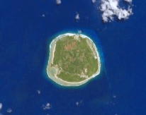
NASA picture of Rimatara Island
|
|
| Geography | |
|---|---|
| Location | Pacific Ocean |
| Coordinates | 22°39′0″S 152°49′12″W / 22.65000°S 152.82000°W |
| Archipelago | Australes |
| Area | 8.6 km2 (3.3 sq mi) |
| Highest elevation | 106 m (348 ft) |
| Highest point | Mount Uahu |
| Administration | |
|
France
|
|
| Overseas collectivity | French Polynesia |
| Administrative subdivision | Australes |
| Commune | Rimatara |
| Largest settlement | Amaru |
| Demographics | |
| Population | 872 (2017) |
| Pop. density | 101 /km2 (262 /sq mi) |
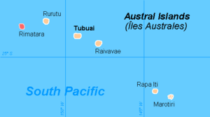
Rimatara is a small, beautiful island in the Austral Islands. These islands are part of French Polynesia, a group of islands in the Pacific Ocean. Rimatara is the most western island in this group where people live.
The island is about 550 km (340 mi) south of Tahiti. It is also 150 km (93 mi) west of another island called Rurutu. Rimatara itself is about 8.6 km2 (3.3 sq mi) in size. There are also some tiny, uninhabited islands nearby called the Maria islets, which are 1.3 km2 (0.50 sq mi). The highest point on Rimatara is 106 m (348 ft) tall. In 2017, about 872 people lived on the island.
Rimatara is shaped like a circle. It is a volcanic plateau, which means it's a flat area made from old lava. A coral reef surrounds the island. This reef is like a natural wall, about 8 to 10 meters (26 to 32 feet) high. The main villages on Rimatara are Amaru, which is the capital, Anapoto, and Mutuaura.
A Look at Rimatara's History
Rimatara was one of the last islands in Polynesia to be visited by Europeans. The first European visitor was Captain Samuel Pinder Henry in 1811.
Later, in 1822, two missionaries arrived from Bora Bora. They started a Protestant mission to share their religion.
Many years later, in 1889, France took control of Rimatara. They set up a "protectorate," which meant France would protect the island. Then, in 1901, France officially made Rimatara a part of its country.
Famous People from Rimatara
- Tamaeva IV, who was a queen of Rimatara.
- Tamaeva V, another queen of Rimatara.
How Rimatara is Governed
|
Rimatara
|
||
|---|---|---|
|
||
 |
||
| Country | France | |
| Overseas collectivity | French Polynesia | |
| Subdivision | Austral Islands | |
| Area
1
|
9.9 km2 (3.8 sq mi) | |
| Population
(2017)
|
872 | |
| • Density | 88.1/km2 (228.1/sq mi) | |
| Time zone | UTC−10:00 | |
| INSEE/Postal code |
98743 /98752
|
|
| Elevation | 0–106 m (0–348 ft) | |
| 1 French Land Register data, which excludes lakes, ponds, glaciers > 1 km2 (0.386 sq mi or 247 acres) and river estuaries. | ||
Rimatara is also a "commune." In France, a commune is like a local government area. The commune of Rimatara includes the main island and the uninhabited Maria Islets.
The commune of Rimatara is made up of three smaller areas, which are called "associated communes":
- Amaru
- Anapoto
- Mutuaura
See also
 If you want to read about Rimatara in Spanish, you can find information here: Rimatara (isla) para niños
 | Percy Lavon Julian |
 | Katherine Johnson |
 | George Washington Carver |
 | Annie Easley |


