
Samoan Islands facts for kids
|
Native name:
Motu o Sāmoa
|
|
|---|---|

Above: Olosega island in the Manu'a group, eastern Samoa Islands. Below: map of the Samoan Islands
|
|
 |
|
| Geography | |
| Location | Polynesia |
| Area | 3,030 km2 (1,170 sq mi) |
| Highest elevation | 1,858 m (6,096 ft) |
| Highest point | Mauga Silisili |
| Administration | |
| Largest settlement | Apia (pop. 38,800) |
| Largest settlement | Tafuna (pop. 9,756) |
| Demographics | |
| Population | 249,839 (2012) |
The Samoan Islands (Samoan: Motu o Sāmoa) are a group of islands in the central South Pacific. They cover about 3,030 square kilometers (1,170 square miles). These islands are part of Polynesia, a large region in Oceania.
The Samoan Islands are split into two main parts. One part is the Independent State of Samoa, which is its own country. The other part is most of American Samoa, which is a territory of the United States. The two parts are about 64 kilometers (40 miles) apart at their closest points.
Around 250,000 people live in the Samoan Islands. Most people here speak the Samoan language. They also share a special culture called fa'a Samoa. Their traditional way of governing is called fa'amatai. Samoans are one of the biggest groups of Polynesians in the world. Most of them have only Samoan ancestors.
People have lived in the Samoan Islands for a very long time. The oldest signs of human life date back to about 1050 BCE. This evidence was found at a place called Mulifanua on Upolu island. In 1768, a French explorer named Louis Antoine de Bougainville visited the eastern islands. He called them the Navigator Islands. This name was used for many years.
Contents
Samoa and American Samoa

The Samoan Islands are divided into two main political areas:
- Samoa: This is an independent country. It became free from New Zealand in 1962. It covers the western part of the islands. This area is about 2,831 square kilometers (1,093 square miles). About 196,000 people lived there in 2016. It was once known as German Samoa and later as Western Samoa.
- Its capital city is Apia. The money used there is the Samoan tala.
- American Samoa: This is a territory of the United States. It includes the eastern part of the islands. It is about 199 square kilometers (77 square miles). In 2020, about 49,710 people lived there.
How the Islands Were Divided
In the late 1800s, the United States, Germany, and the United Kingdom all wanted control of the islands. To solve this, they signed an agreement in 1899 called the Tripartite Convention. This agreement officially split the Samoan Islands. The western half became a German colony, called German Samoa. The eastern half became a territory of the United States, called American Samoa.
During World War I, New Zealand took control of the western islands. They governed them until Samoa became independent in 1962. A group called the Mau movement helped the western islands gain their freedom. The eastern islands are still a territory of the United States today.
Islands of Samoa

The Samoan Islands have 18 islands in total. They stretch from west to east.
- [[Savaiʻi]]: This is the largest island. It is the westernmost island in the group. Volcanoes on Savai'i have erupted recently, like Mt Matavanu (1905–1911).
- Manono: A smaller island.
- [[Nuʻulopa]]: This island is not lived on. It is between Upolu and Savai'i.
- Apolima: A small island with a few people living there.
- Upolu: This island has the most people living on it.
- [[Nuʻusafeʻe]]: A tiny, rocky island that no one lives on. It is off the south coast of Upolu.
- [[Nuʻutele]]: No one lives here. It is a volcanic island and a home for native birds.
- [[Nuʻulua]]: Also uninhabited. It is a volcanic island and a habitat for native birds.
- Namua: No one lives on this island.
- Fanuatapu: This island is also uninhabited and is a volcanic island.
The islands of Manono, Apolima, and Nu'ulopa are located in the Apolima Strait. This strait is between Upolu and Savai'i. The four small, uninhabited islands – Nu'utele, Nu'ulua, Namua, and Fanuatapu – are off the east coast of Upolu. They are known as the Aleipata Islands.

Islands of American Samoa
- Tutuila: This is the main island in American Samoa.
- Pola Island: No one lives on this island. It is part of the National Park of American Samoa.
- Aunu'u: This island is southeast of Tutuila.
- Swains Island: No one lives here. It is part of American Samoa but is culturally linked to Tokelau.
- Ofu‑Olosega: These are two volcanic islands, Ofu and Olosega, that are very close together. They are in the Manu'a Group.
- Ta'ū: This is the largest island in the Manu'a Group.
- Manu (Rose Atoll): No one lives here. It is a special place for native birds, marine life, and turtles.
- There are also several other small, uninhabited islands.
Location of the Islands

The Samoan Islands are located far from other major landmasses. They are about 800 kilometers (500 miles) from Fiji. They are also about 530 kilometers (330 miles) from Tonga. New Zealand is about 2,900 kilometers (1,800 miles) away. Hawaii, U.S., is about 4,000 kilometers (2,500 miles) away.
The islands are between 13° and 14° south of the equator. They are also between 169° and 173° west longitude. The whole island chain stretches about 480 kilometers (300 miles) from west to east.
The larger islands were formed by volcanic activity. They are mountainous and covered in thick tropical forests. Some of the smaller islands are coral atolls. These often have beautiful black sand beaches.
Highest Points
The highest point in Samoa is Mount Silisili. It is on the island of Savai'i. At 1,858 meters (6,096 feet) tall, it is one of the highest peaks in all of Polynesia.
The highest peak in American Samoa is on Ta’u island. This peak is called Lata Mountain. It is 966 meters (3,169 feet) high.
Land Area
Upolu and Savai'i in Samoa are among the largest islands in Polynesia. Upolu is about 1,718 square kilometers (663 square miles). Savai'i is about 1,125 square kilometers (434 square miles). Only a few other islands in the Pacific are larger. Upolu has more people living on it than Savai'i.
The next largest island is Tutuila. This is where the city and harbor of Pago Pago are located. Tutuila is much smaller than Upolu and Savai'i. It is about 136.2 square kilometers (52.6 square miles) in area. However, it is the largest island in American Samoa. The highest point on Tutuila is Matafao Peak.
Smaller islands include Manono Island, Apolima, and Nu'ulopa. These are in the Apolima Strait between Savai'i and Upolu. The four Aleipata Islands are off the eastern end of Upolu. These are Nu'utele, Nu'ulua, Namua, and Fanuatapu. Nu‘usafe‘e is also a small island. Aunu'u is a small island off the eastern end of Tutuila. To the east of Tutuila, the Manu'a group includes Ofu, Olosega, and Ta’u. Rose Atoll is an uninhabited coral island. It is the southernmost point in the United States territory. Swains Island is another coral island. It is part of American Samoa but is far from the main Samoan islands.
Time Zone Changes
In 1892, the Samoan islands changed their time zone. They moved to the eastern side of the International Date Line. This meant that Monday, July 4, happened twice that year! This change was likely made to help with trade with Americans. It put the islands on the same day as the United States.
However, in 2011, the government of independent Samoa decided to change back. They moved to the western side of the date line. This was so they could be on the same day as Australia and New Zealand. These countries are Samoa's main trading partners. Being a day behind them meant only four business days in a week. To make the change, they skipped Friday, December 30. Workers were still paid for this "missed" day. Neighboring Tokelau also made this change.
How the Islands Were Formed
-1.svg)
The Samoan islands are a chain of volcanic islands. Scientists think they might have been formed by something called the Samoa hotspot. Imagine the Earth's outer layer, called the Pacific tectonic plate, moving over a very hot spot deep inside the Earth. This hot spot, called a mantle plume, sends hot rock up through the Earth's crust. This process can create volcanoes and islands.
One reason scientists think this is that the islands generally line up in a straight east-to-west direction. The Pacific plate is also moving from east to west. However, some things about the Samoan islands don't quite fit this idea. For example, the classic hotspot idea says that islands farther from the hotspot should be older. But Savai'i, the westernmost island, and Ta'u Island, the easternmost, both had eruptions in the last century. This was a puzzle for scientists.
In 2005, a group of scientists found new evidence. They took rock samples from deep under Savai'i. These samples were about five million years old. This age fits the hotspot idea better. This new evidence helps explain how the Samoan islands were formed by a hotspot.
2009 Samoa Earthquake and Tsunami

On September 29, 2009, a very strong submarine earthquake happened near the Samoan Islands. It was an 8.1 magnitude earthquake. This earthquake caused a tsunami that hit the Samoan Islands and Tonga. More than 170 people died. It was the largest earthquake of 2009.
Vailulu'u Seamount
The Vailulu'u Seamount is an active underwater volcano. It is located about 45 kilometers (28 miles) east of Ta'u in American Samoa. Scientists found it in 1975. They have been studying it to learn more about how the Earth works. Inside the top of Vailulu'u, there is an active underwater volcanic cone. It is named Nafanua, after Samoa's goddess of war.
Climate
The Samoan Islands have a tropical climate. This means it is warm all year round. There is a rainy season from November to April. Because of their location in the South Pacific, the islands are often hit by tropical cyclones between December and March.
Gallery
- Samoa Islands
-

Mt Matavanu volcanic eruption on Savai'i island, 1905
-
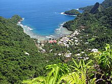
Afono village, Tutuila island, American Samoa.
-
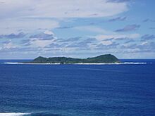
Aunu'u island, offshore of the island of Tutuila, American Samoa
-
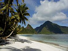
A beach on Ofu-Olosega, a volcanic doublet in the Manu'a Group of islands.
-
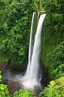
Fuipisia waterfall in Lotofaga, Upolu island.


See also
 In Spanish: Archipiélago de Samoa para niños
- Archaeology of Samoa
- Architecture of Samoa
- Culture of Samoa
- First Samoan Civil War
- Samoan unification
- Second Samoan Civil War
- Siege of Apia
- Tokelauan language
- Tuvaluan language
