
Tutuila facts for kids

Tutuila and Aunu'u from Earth orbit
|
|
 |
|
| Geography | |
|---|---|
| Location | Map of Tutuila Island in American Samoa in Pacific Ocean |
| Coordinates | 14°17′42″S 170°42′00″W / 14.295°S 170.70°W |
| Archipelago | Samoan Islands |
| Area | 142.3 km2 (54.9 sq mi) |
| Highest elevation | 653 m (2,142 ft) |
| Highest point | Matafao Peak |
| Administration | |
|
United States
|
|
| Territory | American Samoa |
| Largest settlement | Pago Pago (pop. 11,500) |
| Demographics | |
| Population | 55,876 (2000) |
| Pop. density | 394.89 /km2 (1,022.76 /sq mi) |

Tutuila is the main island of American Samoa. It is also the largest island in this US territory. Tutuila is part of the Samoan Islands chain in the Central Pacific. It is the third largest island in the entire Samoan group.
The island is about 4,000 kilometers (2,500 miles) northeast of Brisbane, Australia. It lies over 1,200 kilometers (750 miles) northeast of Fiji. Tutuila has a large, natural harbor called Pago Pago Harbor. The capital of American Samoa, Pago Pago, is located here. Pago Pago International Airport is also on Tutuila.
Tutuila makes up about 68% of American Samoa's total land area. About 95% of American Samoa's population lives here, with around 56,000 people. The island has six land-based and three ocean-based natural environments. Tutuila has mountains, with the highest point being Matafao Peak at 653 meters (2,142 feet). Tourists enjoy the island's beaches, coral reefs, and World War II sites. It is also great for activities like scuba diving, snorkeling, and hiking.
Contents
What's in a Name?
The name Tutuila might have come from a woman named Salaia. She is said to have combined her parents' names, Tutu and Ila. Another name for the island is 'o le motu o Salaia, meaning "the island of Salaia." It is also called motu sā, which means "the sacred island."
Island Legends
A popular story on the island tells of a shark and a turtle. They are said to appear near the shore when called in a special way. Long ago, an old blind woman and her granddaughter were very hungry. They jumped off a cliff in Vaitogi village into the ocean. Instead of drowning, the old woman became a shark, and her granddaughter became a turtle. When villagers sing a certain chant, the shark and turtle appear.
Another Samoan legend is about the flying fox bat. These bats live in a forest area of Tutuila, which is part of the National Park of American Samoa. The legend says the flying fox is a protector and guardian of the forest. It also protects the people who live there.
Island History
Polynesians first arrived in Samoa around 1000 BC. By 600 BC, they had built a settlement on Tutuila at Tula. Over many centuries, Samoans on Tutuila stayed in touch with people from nearby islands. These included Western Polynesia, Tonga, and Fiji.
Tutuila was sometimes used as a place for warriors and chiefs. They were sent there if they lost wars on the island of Upolu. Rulers from Upolu also sent political opponents to Tutuila.
First European Visitors
In 1722, Jacob Roggeveen was the first European to visit the Manu'a islands. These islands are at the eastern end of the Samoan chain. In 1768, explorer Louis Antoine de Bougainville visited Samoa. He called them the "Navigator Islands." This was because islanders were skilled at navigating canoes to catch tuna.
European whalers and Protestant missionaries started arriving in the early 1800s. Many came in the 1830s. Two important visitors were John Williams from the London Missionary Society. The French explorer Louis de Freycinet also arrived in October 1819. He named Tutuila “Rose Island” after his wife, Rose de Freycinet. European traders and Samoans chose to develop Apia on Upolu Island as their main trading spot. They did not choose Pago Pago on Tutuila.
Becoming Part of the United States
In 1872, the US Navy saw that Tutuila’s Pago Pago Harbor was perfect. It could be a refueling station for steamships traveling from San Francisco to Sydney. The US made a treaty with the islanders for this use. Six years later, in 1878, the US Congress approved this treaty.
However, the US was not the only country interested in the Samoan islands. Great Britain and Germany had also shown interest since the 1860s. In 1879, the Samoans agreed to work with all three countries. So, the United States, Great Britain, and Germany formed a shared government over the islands.
In 1889, the three countries met in Berlin. They discussed the future of the islands and tried to solve their disagreements. The Americans wanted more control. Their ongoing differences led to a plan in 1899. This plan divided control among different parts of the Samoan islands. The eastern islands, including Tutuila and Aunu'u, became American Samoa. The western islands became Western Samoa under European control.
Samoans agreed to this plan in 1900. The US flag was raised on Tutuila on April 17 of that year. The name “American Samoa” was officially given to the eastern islands in 1911. The agreement was formally approved in 1929.
Tutuila During World War II
During World War II, Tutuila was very important for the US Marines. They built a military base there. They also put up concrete bunkers along the island’s coast. The island was very important, but it was mostly safe from the war. The only attack was from a Japanese submarine on January 11, 1942. Since 1951, the US Department of the Interior has been in charge of Tutuila and other American Samoa islands.
Modern American Samoa

In 1956, Peter Tali Coleman became the first Samoan-born governor of American Samoa. During his time, rules were approved to protect the islanders. These rules protected their lands and cultural practices. After 1960, the Flag of American Samoa became the official flag.
In 1961, US President John F. Kennedy appointed H. Rex Lee as governor. He approved a lot of US money to develop Tutuila. In the 1960s, this money helped build an international airport, seaport, roads, schools, houses, and a hospital. It also funded a tuna cannery and a modern hotel. Electricity was installed across the country. In 1962, Western Samoa became independent from New Zealand. This made people wonder if the US would keep control of American Samoa. The large US development efforts in the 1960s helped ensure that Tutuila and American Samoa remained a US territory.
In July 1997, Western Samoa changed its legal name to “Samoa.” Many Americans, including people in American Samoa, did not like this. They felt that using just “Samoa” for the western islands would be confusing. It might also make American Samoa seem less distinct. Many American Samoans still call Samoa “Western Samoa.” They also call its people “Western Samoans.”
Today, American Samoa is a US territory. It is managed by the US Interior Department’s Office of Insular Affairs. American Samoa is divided into two main political areas. These are the Eastern District and the Western District.
Island Geography

Tutuila is in the Pacific Ocean. It is about 4,000 kilometers (2,500 miles) northeast of Brisbane, Australia. The village of Fagatogo is about 1,238 kilometers (769 miles) northeast of Suva, Fiji. The island is roughly 530 kilometers (330 miles) north of Niue. It is also about 580 kilometers (360 miles) south of Tokelau. Tutuila is about 100 kilometers (62 miles) southeast of the Samoan island of Upolu.
Tutuila is a small and narrow island. It is about 33 kilometers (21 miles) long. At its widest point, it is a little more than 3 miles (4.8 kilometers) from north to south. This volcanic island is about 142.3 square kilometers (54.9 square miles) in area. Its shoreline is about 101.3 kilometers (62.9 miles) long.
The hills run from west to east and are rugged. The northern coast has steep cliffs and an unusual shoreline. The southern part of the island is flatter. There are good beaches in many places along the coast. Tutuila has a wet tropical climate.
The highest point on Tutuila is Matafao Peak. It is 653 meters (2,142 feet) high. There is a trail opposite Mount Alava peak (483 meters or 1,585 feet). Mount Alava dominates the northern part of the island. This 9.7-kilometer (6.0-mile) trail starts with a metal stairway. It goes up to the peak. Walking along the ridge through the rainforests is beautiful. The views of the South Pacific Ocean are amazing.


In the early 1800s, sailors passed through Tutuila. It was also known as Bougainville, Manuo, or Maouna. The Pago Pago harbor was seen between a small island and a rock. It was marked by a cone-shaped hill on its west side. A flat, oval-topped hill was to the east. Leone village, which was large and successful, was seen to the west. To the southeast of Tutuila is the small island of Aunu'u.
A coastal road runs for 50 kilometers (31 miles). It goes from Fagamalo in the northwest to Onenoao in the far northeast. Important towns and villages on the island include:
- The Tafuna Urban area: This is the largest urban area. It includes villages from 'Ili'ili to Tafuna.
- Fagatogo: This is the largest town with government offices in Utulei.
- Pago Pago: A deep harbor town across from Fagatogo. It divides the island into two parts.
- Vatia village: On the northern coast, known for its beach and views. It is a coral-fringed bay.
- Leone: A safe harbor in the past. Europeans and Samoans first met here.
The southwesternmost settlement is Taputimu. The westernmost settlements are Poloa and Amanave. The northernmost settlement is Vatia. The easternmost settlement is Tula.
Island Population
The island had a population of 55,876 people in the 2000 census. These numbers include Aunu'u Island. Aunu'u is off the southeast coast of Tutuila. It has a land area of 1.517 square kilometers (0.586 square miles) and a population of 476.
Island Economy


The economy of American Samoa mostly relies on money from the U.S. Department of Interior. The tuna canning and fishing industries provide most of the money earned. Tourism is also a growing part of the economy.
Economic activity is strongly connected to the US. American Samoa does most of its business with the US. Money from the US government greatly helps American Samoa's economy. The government wants to grow the economy more. But it is limited by Samoa's distant location and limited transportation.
More than 90% of the land is owned by the community. Tuna fishing and tuna processing plants are very important. Canned tuna is the main product exported. Urban areas have grown around Pago Pago Harbor. This is where fishing and canning factories are located. The largest tuna processing plant in the world, StarKist, is in Atu'u. It is across the bay from Fagatogo. There is also a workshop in the harbor that repairs fishing ships.
Island Ecosystems

Tutuila has six land-based and three ocean-based natural environments. There are two protected areas on the island. These are the National Park of American Samoa, covering 2,000 hectares (4,900 acres). The other is the Fagatele Bay National Marine Sanctuary, which is 66 hectares (160 acres).
Island Plants
The plants on the island are mostly lowland and montane rainforests. The lowland rainforest is below 300 meters (980 feet) in elevation. It has many Diospyros, Dysoxylum, Pometia, and Syzygium species. The montane forest is between 300 and 700 meters (980 and 2,300 feet) high. It includes Dysoxylum, montane scrub, streams, bushes, mangroves, mangrove lagoons, reefs, and underwater coral banks.
Island Animals
There are 19 types of land snails on the island. Eleven of these are found only here. Four are in danger of disappearing. Mt. Matafao has many snail species. Scientists have studied them since 1917. Some unique snails found here are the Diastole matafaoi (which might be extinct). Another is the Samoana abbreviata (short Samoan tree snail). The Achatina fulica (giant African land snail) was brought in 1975. It has damaged gardens. Two types of flying foxes (bats) are also found on the island. They are described in the National Park section.
Ocean Animals
Scientists have found 174 species of hard corals. These belong to 48 different groups.
Island Birds
Many bird species found here are unique to the island. These include:
- The Aplonis atrifuscus (Samoan starling)
- The Gymnomyza samoensis (black-breasted honeyeater)
- Halcyon recurvirostris (flat-billed kingfisher)
- Lalage sharpei (Samoan triller)
- Myiagra albiventris (white-vented flycatcher)
- Pachycephala flavifrons (yellow-fronted Samoan whistler)
- Rhipidura nebulosa (Samoan fantail)
Four types of native doves and pigeons live on all the Samoan islands. These are the Pacific imperial pigeon (Ducula pacifica), the crimson-crowned fruit dove (Ptilinopus porphyraceus), many-colored fruit dove (Ptiliopus persousii), and shy ground dove (Galicolumba stairi).
Butterflies are another type of flying animal on the island. The types found here include the Hypolimnas thompsoni and Papilio godeffroyi.
National Park of American Samoa

The National Park of American Samoa on Tutuila was created in 1988. Its goal is to protect the island's land and ocean environments. It covers 2,000 hectares (4,900 acres). It is located on the north coast between Fagasa and Afono villages. The Rainmaker pass is inside this park, with its rainforests. The Amalau Valley is between the Afono and Vatia villages. This valley has many types of birds and animals.
The most important animals are two types of flying fox bats. Local Samoans believe these bats protect the forest and its people. The two flying fox species protected in the park are:
- Pteropus samoensis (called pe'a voa). This means "fruit bat of the forests." They have light-colored faces and brown bodies. They rest alone or in small groups in treetops. They are active during the day, with two times they feed most.
- Pteropus tonganus (called pe'afaunua). This means "fruit bat of settled lands." They have black faces and dark brown bodies. They rest in large groups (100 or more) in thick forests. Sometimes they are seen near villages.
Both species have a wingspan of about 1 meter (3.3 feet) when fully grown. They weigh about 500 grams (1.1 pounds).
The park is divided into three areas and has many hiking trails. The National Park Service (NPS) provides good information about these trails. One trail goes up Mount Alava, a high peak in the park. It rises to 491 meters (1,611 feet). There is a TV tower on this mountain. There are also ruins of a cable car station. This cable car once ran over Pago Pago Harbor to Solo hill in Utulei. It was 1.8 kilometers (1.1 miles) long. This cableway was built in 1965 and was the only single-way cable in the world at that time. It was damaged on April 17, 1980, when a Navy plane hit one of the cables. It was never used again. The cableway was used to take TV technicians to the station. The path down from the peak offers lovely views of the park's lowlands and rainforests. These areas are full of many bird species.
Another ridge trail runs from Fagasa Pass for 6.5 kilometers (4.0 miles). It goes through very steep slopes behind a hurricane shelter. This part also has a stairway. It leads down to the peaceful Vatia village on the coral bay.
Natural Disasters


Hurricanes, also called tropical cyclones, have often hit the Samoan Islands for centuries. To watch for and warn about cyclones, several observation stations have been set up. These are part of the U.S. Federal Emergency Management Agency (FEMA).
The first recorded hurricane in modern times hit the Samoan islands on February 10, 1966. It was declared a major disaster. After this, "hurricane homes" called "fale afa" were built. People could use these homes for shelter during storms. Since the 1966 hurricane, the islands have faced many disasters. These include heavy rains, hurricanes, and droughts. There was a drought in 1974. Floods, mudslides, and landslides happened in 1979. Hurricanes hit in 1981, 1987, 1990, 1991, and 2004. A tsunami struck in 2009.
The hurricane from December 4–13, 1991, was the worst disaster. It was named "Hurricane Val." It caused huge damage to property in American Samoa and Western Samoa. Hurricane Val was very strong. Its winds were over 100 knots or 166 kilometers (103 miles) per hour. It was said to be the worst in 100 years for its wind strength and damage.
According to the National Oceanic and Atmospheric Administration's (NOAA) American Samoa observatory, "Hurricane Val" hit Tutuila Island from December 7–10. The eye of the hurricane passed over the southern end of the island. Winds as high as 116 miles (187 kilometers) per hour were recorded. In Fagatele Bay on Tutuila, where Hurricane Val passed directly, the coral reef was completely destroyed. A large part of the coast was also washed away.
After this disaster, NOAA sent a team to check the damage to the reefs. The cableway was badly damaged and stopped working forever. The TV tower at Utulei was also completely destroyed by Val. This meant parts had to be used to keep the other two TV channels working. The Fagalele Boys School was also destroyed by Hurricane Val. It was one of the oldest European-style buildings. It was built in the mid-1800s in Leone village.
Historical Places to Visit

At Utulei, near Blunts Point, you can see two guns from World War II. They are from 1941. They look like two metal tubes sticking out of a wall. The guns are at two levels. The lower gun is above a green water tank. The second gun is 200 meters (660 feet) above the first, on the ridge. You can reach both guns by a concrete staircase. Also, two more guns like these are at the harbor mouth. They were placed there to create a crossfire. Concrete bunkers used during WWII can also be seen at Pago Pago.
Important buildings in Fagatogo include:
- The Governor's Mansion (built in 1903).
- The Fono Building, which is the state legislative building.
- The Jean P. Haydon Museum, built in 1917. This was once the navy headquarters.
- The Catholic Cathedral with a painting of a Holy Family scene at the beach.
Other notable places are:
- The Zion Church (1900) in Leone. Leone was the old capital of Tutuila.
- A monument in front of the church honoring John Williams. He was the first missionary to visit Tutuila in 1832.
- The Radio Towers at Mt. Olotele.
- Massacre Bay in Aasu village. A monument was put here in 1883. It has a stone cross. It honors 11 French sailors who died in a fight. They were from the Astrolabe and Boussole ships during the La Parouse expedition. They were killed by local Samoans on December 11, 1787. Eleven Chinese and 39 Samoans also died in this fight. However, they are not mentioned on the monument.
At the old cable car terminal on Solo Hill in Utulei, there is a monument. It honors six US Navy people who died in a plane crash. The plane hit the cableway and crashed into the Rainmaker Hotel. Two tourists staying at the hotel also died in the crash.
Images for kids
-
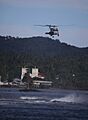
U.N. Air Rescue Helicopter during rescue operation in Pago Pago.
-
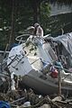
Destruction to a boat due to Tsunami in Pago Pago.
See also
 In Spanish: Tutuila para niños
