
Ofu-Olosega facts for kids
Quick facts for kids Ofu-Olosega |
|
|---|---|

Ofu-Olosega from the Space Shuttle
|
|
| Highest point | |
| Elevation | 639 m (2,096 ft) |
| Prominence | 639 m (2,096 ft) |
| Geography | |
| Location | American Samoa |
| Topo map | USGS |
| Geology | |
| Mountain type | Shield volcanoes |
| Last eruption | September to November 1866 |
Ofu and Olosega are two islands in the Manu‘a Island Group. This group is part of American Samoa in the Samoan Islands. These twin islands were formed from shield volcanoes. They are about 6 kilometers (3.7 miles) long together and cover an area of 12 square kilometers (4.6 square miles). Around 500 people live on these islands.
The islands are actually parts of one large volcano that split. They are separated by a narrow stretch of water called the Āsaga Strait. This strait is about 137 meters (449 feet) wide and has shallow coral reefs. Before 1970, people could walk between the islands at low tide. Since 1970, a bridge has connected them with a single-lane road.
The highest point on Ofu Island is Mount Tumutumu, which is 491 meters (1,611 feet) tall. On Olosega, the highest point is Mount Piumafua, standing at 629 meters (2,064 feet). The last time a volcano erupted near these islands was in 1866. This eruption happened about 3 kilometers (1.9 miles) southeast of Olosega.
Scientists have found very old items on Ofu Island. These discoveries happened during archaeological digs in the 1980s. These items helped us learn a lot about the ancient history of Ofu, the Samoa Islands, and Polynesia. The artifacts include pottery, adzes (tools), and pieces made from shell and bone. Some of the pottery looks like it was made by the Lapita culture. This culture was known for its unique pottery.
The archaeological work was done by a team that included Pacific archaeology expert Patrick Vinton Kirch. They focused on a place called To'aga on the south coast of Ofu. This area is about 2 kilometers (1.2 miles) long. By studying the age of the artifacts, scientists believe that people have lived on Ofu for about 3,000 years!
Contents
Ofu Island

Ofu is the western part of the Ofu-Olosega island and the most western of the Manu'a Islands. The main village of Ofu is on the western shore. It is protected by a small island offshore called Nu'utele. This small island is an eroded volcano cone.
Ofu has a small airport and a boat harbor. These help people travel to and from Ofu and Olosega. A flight from Pago Pago takes about 30 minutes.
Most of the southern shore of Ofu and its coral reef are part of the National Park of American Samoa. In 2005, the U.S. National Park Service was talking with village leaders on Olosega. They wanted to make the park bigger to include parts of Olosega too.
Ofu Island is also a part of the Ofu County subdivision within the Manua District. In 2010, the island had a population of 176 people. Its land area is about 7.215 square kilometers (2.786 square miles).
On the south coast of Ofu is the To'aga lagoon. This lagoon has many different kinds of corals and fish. Scientists have been studying this marine area for a long time. They use it to learn about coral reefs and how they are affected by global climate change.
The island is also home to the Samoa Flying-fox. This is a type of bat. It is threatened because it is losing its natural home.
Olosega Island

Olosega is the smallest island in Manu'a. As mentioned, you can sometimes walk to Ofu Island from Olosega when the tide is low.
Olosega Island is what's left of the Sili shield volcano. The main crater of this volcano might be underwater off the north shore.
The volcanic eruption in 1866 was actually about 3 kilometers (1.9 miles) east of Olosega. It happened on a ridge under the ocean. This ridge stretches east towards the nearby island of Ta‘ū.
Olosega Island forms the Olosega County subdivision of the Manua District. In 2010, it had a population of 172 people. Its land area is about 5.163 square kilometers (1.993 square miles).
There are four villages on Olosega: Olosega, Lalomoana, Sili, and Faiava.

Gallery
-
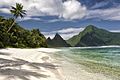
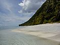
A beautiful beach on Ofu Island.
-
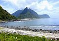
A view of the clear waters around Ofu.
-
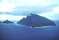
An aerial view showing the green landscape of Olosega.
-
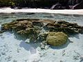
Coral and beach on Ofu-Olosega.
-
A close-up of the sand and water.
-
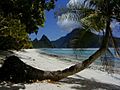
A curved palm tree on the shore.


See also
 In Spanish: Ofu y Olosega para niños
