
Tahuata facts for kids
Quick facts for kids
Tahuata
|
|
|---|---|

A satellite image of Tahuata
|
|

Location of the commune (in red) within the Marquesas Islands
|
|
| Country | France |
| Overseas collectivity | French Polynesia |
| Subdivision | Marquesas Islands |
| Area
1
|
61 km2 (24 sq mi) |
| Population
(2017)
|
653 |
| • Density | 10.70/km2 (27.73/sq mi) |
| Time zone | UTC−09:30 |
| INSEE/Postal code |
98746 /98743
|
| Elevation | 0–1,050 m (0–3,445 ft) |
| 1 French Land Register data, which excludes lakes, ponds, glaciers > 1 km2 (0.386 sq mi or 247 acres) and river estuaries. | |
Tahuata is the smallest island where people live in the Marquesas Islands. These islands are part of French Polynesia, which is an overseas territory of France in the Pacific Ocean. Tahuata is located about 4 kilometers (2.5 miles) south of Hiva Oa. A channel called the Canal du Bordelais (or Ha‘ava in the local language) separates the two islands.
Contents
Island History: A Look Back
Early Settlers and Tribes
Experts who study old sites (called archaeologists) have found proof that people from Polynesia lived on Tahuata as early as the year 200 AD.
Before Europeans arrived, the different groups (or tribes) on Tahuata worked together with tribes from the Nuku area of Hiva Oa. Tahuata was seen as a smaller area connected to that larger province.
First European Visitors
The first time Europeans officially saw Tahuata was on July 22, 1595. This was during a Spanish trip led by Álvaro de Mandaña. They named the island Santa Cristina. They landed at a place they called Madre de Dios, which is now Vaitahu.
The Spanish visitors wrote that Tahuata had chickens, fish, sugar cane, bananas, nuts, and other fruits. The main town had houses made of wood and woven plants. There was also a special building, possibly for religious purposes, with carved images and offerings. The people had large, well-built canoes. They used tools made from shells and fish bones, and fought with slings, stones, and spears.
In 1774, Captain James Cook visited Tahuata. He wrote in his travel diary that the island, which Mendaña called Santa Christina, was known locally as Ohitahoo.
Tribal Life and Changes
According to Cook, four main tribes lived on the island. The Hema tribe lived in the bays of Vaitahu and Iva Iva. The Ahutini tribe lived in Hapatoni, Hanateio, and Hanatetena. The Uavi tribe lived in the valleys or on the high lands. The Tupohe tribe lived in the Motopu valley. Later, the Hema and Ahutini tribes joined forces and the Tupohe tribe disappeared.
France Takes Over
In 1842, a French Admiral named Dupetit-Thouars came back to the Marquesas Islands. The French King, King Louis Philippe, had sent him to find a good spot in the Pacific for French traders and whalers. At that time, a single chief named Iotete led all of Tahuata.
Chief Iotete asked Dupetit-Thouars for some men, horses, and cannons. He was worried that Americans might try to take over his island. Dupetit-Thouars used this chance to have Iotete sign a paper on May 1, 1842. In this paper, Iotete agreed that France would rule over the southeastern Marquesas Islands. This made Tahuata a French territory.
A few months later, Iotete realized he had lost his power. In September, he and his people went into the mountains. On September 18, 1842, fighting broke out. Twenty-four French sailors and two officers were killed. But the French had strong cannons from two warships and help from other Marquesans. The Marquesans from Tahuata went back to the mountains, and peace was agreed upon on September 23.
Over time, France became more interested in Tahiti and other islands, and less in the Marquesas. The French soldiers in Vaitahu slowly left, and the base was empty by 1847. Missionaries also left in 1849. The old ways of life on the island faded, and Tahuata faced challenges for over 30 years.
In 1880, another French Admiral, Bergasse Dupetit-Thouars, brought order back to the southeastern Marquesas. He placed police officers (called gendarmes) in Vaitahu. The French presence has remained on Tahuata ever since.
Island Geography: Mountains and Beaches
Tahuata has a land area of about 61 square kilometers (23.6 square miles). The highest point on the island is Mount Amatea, which is 1,050 meters (3,445 feet) tall. The island is very mountainous, with deep valleys and steep cliffs. Because of its rugged shape, there is no space to build an airstrip (airport runway). So, people travel to and from the island by sea, usually from the nearby island of Hiva Oa.
Tahuata is just south of Hiva Oa, the main island of the southern Marquesas group. They are separated by the Canal du Bordelais (Ha'ava in Marquesan), which is only three kilometers (1.9 miles) wide. This channel has strong sea currents.
The island is shaped like a crescent moon and is about 15 kilometers (9.3 miles) long. It has a central mountain ridge that runs along its entire length. The slopes are steep, cut by deep valleys, and high cliffs end in rocky points. This makes for a very rugged coastline.
Tahuata also has small bays with beautiful white sandy beaches and clear water. In fact, Tahuata has more coral formations than most other Marquesan islands, which usually don't have many.
How the Island Was Formed
Tahuata is a high volcanic island. It has a mountain range that reaches 1,050 meters (3,445 feet) at Mount Tumu Mea Ufa and 1,000 meters (3,280 feet) at Mount Pahio. This mountain range is what is left of the main crater (called a caldera) of the volcano that created the island. This old crater was about nine kilometers (5.6 miles) wide.
Inside this large crater, there is another, lower mountain rim. This shows where a second, smaller crater might have been. This smaller crater was likely about four kilometers (2.5 miles) wide and mostly underwater. Scientists are still studying if this was from a second volcano or another collapse of the first one.
Tahuata is between 2.90 and 1.75 million years old. It formed around the same time as its neighbor, Hiva Oa. It's possible that both islands were once part of the same large volcanic system.
Island Administration: How Tahuata is Governed
Administratively, Tahuata is a commune (like a municipality or town) in French Polynesia. It is part of the Marquesas Islands administrative area. The commune of Tahuata includes only the island of Tahuata itself.
The main administrative center of the commune is the village of Vaitahu, which is located on the western side of the island.
Island Population: Who Lives Here
| Historical population | ||
|---|---|---|
| Year | Pop. | ±% |
| 2002 | 671 | — |
| 2007 | 671 | +0.0% |
| 2012 | 703 | +4.8% |
| 2017 | 653 | −7.1% |
An expert named Nicholas Thomas believes that the population of Tahuata was much larger in the past. He estimates there were at least 7,000 people in 1800, about 4,000 in 1830, and 2,000 in 1840.
Today, the people live in four main villages. Two are on the west side: Vaitahu and Hapatoni. Two are on the east side: Motopu and Hanateio. Each village is in a different valley.
The island's population is growing slowly. Even though there is no airport, being close to Hiva Oa helps prevent the population from shrinking, unlike some other islands. In 2012, there were 703 people living on the island.
The people of Tahuata speak the southern Marquesan language and French. French is the only official language here.
Religion on Tahuata
Most people on the island today follow Christianity. Missionaries from both Catholic and Protestant groups brought this religion to the area. The Catholic Church manages four churches on Tahuata. These include the Church of Saint Joseph in Hanatetena, the Church of the Sacred Heart of Mary in Hapatoni, the Church of Our Lady of the Seven Sorrows in Motopu, and the Church of the Holy Mother of God in Vaitahu.
Island Economy: How People Make a Living
Tahuata's economy mainly relies on basic activities like farming and fishing. The rich valleys are good for growing cassava and bananas, as well as copra (dried coconut meat) and noni fruit. Until the 1980s, people also grew coffee. Fishing is also very important, especially catching lobsters.
Handicrafts (things made by hand) provide extra income. Almost all the men on Tahuata carve beautiful items from rosewood and bone, such as horse or fish bones, and swordfish bills. Their carvings often show traditional Marquesan and Polynesian designs. There is a handicraft center in Vaitahu, near the town hall. Artisans sell their creations to tourists and traders who then sell them in Tahiti.
Tahuata is less visited by tourists compared to its larger neighbor, Hiva Oa. However, it has many wonderful things to see, both natural and cultural. On the east coast, you can find lovely white sand beaches, thanks to the coral formations around the island. In Vaitahu, you can visit the modern church, which blends European and Marquesan styles. There's also an archaeological museum, the harbor where the first Western explorers landed, and the remains of a French fort built in 1850. In Hapatoni, you can see the royal alley, the church, and an ancient sacred site called a marae. The Hanateio valley has archaeological sites with old rock carvings (petroglyphs) that are still well-preserved.
In March 2006, Tahuata hosted the first small artistic festival for the Marquesas Islands.
Island Infrastructure: Getting Around and Services
Vaitahu is home to the town hall, a post office, and a small medical clinic (infirmary). There are no banks on the island, and credit cards are not used. There are kindergartens and primary schools in the different villages.
There is no airport on Tahuata. To get there, you need to fly to Hiva Oa's airport first. From Hiva Oa, you can take other transport options. These include the local catamaran boat called Tahuata Nui (a 50-minute trip), a helicopter (10 minutes), or speedboats. Cargo ships also visit the island regularly. The Aranui comes every three weeks, and the Taporo comes once or twice a month. Because the land is so rugged, large ships cannot dock directly. Passengers and goods have to use smaller boats to get to shore.
Images for kids
-
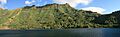
West coast of Tahuata Island, from Hapatoni bay.
-
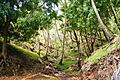
Coconut forest in Tahuata
-
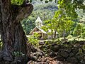
Immaculate Heart of Mary Church in Hapatoni
-
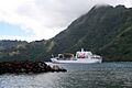
The Aranui anchored at the island


See also
 In Spanish: Tahuata (isla) para niños
