
Gilbert Islands facts for kids
The Gilbert Islands (called Tungaru by local people) are a group of sixteen islands in the Pacific Ocean. These islands are the main part of the country called Kiribati. They are known for their beautiful atolls and rich ocean life.
Contents
Where are the Gilbert Islands?
The Gilbert Islands are located in the central Pacific Ocean, right on the Equator. They are part of a larger region called Micronesia. Because they are spread out over a large area of the ocean, the islands are quite far apart from each other.
What are atolls?
Many of the Gilbert Islands are atolls. An atoll is a special type of ring-shaped coral reef that surrounds a lagoon. It forms when a coral reef grows around a volcanic island that later sinks or erodes. The lagoon inside the atoll is usually calm and clear, making it a great place for marine animals.
Life on the Islands
Life on the Gilbert Islands is closely connected to the ocean. Fishing is very important for the people who live there. They also grow crops like coconuts and breadfruit, which are well-suited to the island environment. The climate is tropical, meaning it's warm all year round with plenty of sunshine.
A Glimpse into History
The Gilbert Islands were named after Captain Thomas Gilbert, a British explorer who visited them in 1788. Before that, people had lived on these islands for thousands of years, developing their own unique culture and traditions.
During the 19th and 20th centuries, the islands became part of the British Empire. They were known as the Gilbert and Ellice Islands Colony. In 1979, the Gilbert Islands gained their independence and became the country of Kiribati. The name "Kiribati" is actually the local way of saying "Gilberts."
Interesting Facts
- The capital city of Kiribati, South Tarawa, is located on one of the Gilbert Islands.
- Because the islands are very low-lying, they are especially concerned about sea level rise due to climate change.
- The people of Kiribati are known as I-Kiribati, and their language is Gilbertese.
Images for kids
-
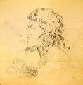
Portrait of a native of the Makin islands, drawn by Alfred Thomas Agate (1841)
-
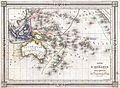
1852 map by J. G. Barbié du Bocage. It shows regions like Polynesia, Micronesia, Melanesia and Malesia.
-

Map of Abaiang and Tarawa, from US Ex Ex


.jpg)
See also
 In Spanish: Islas Gilbert para niños
