
Image: BlackRockGunneryRangeElkoAeroChart1955
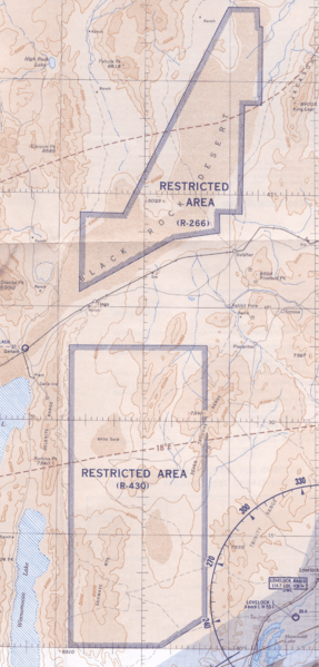
Description: This 1955 Elko Sectional Aeronautical Chart shows the approximate location of the Black Rock Desert Gunnery Range. The back side of the map has a table titled "U. S. Prohibited, Restricted, Caution and Warning Areas on Elko Sectional Chart". The table states that R-266 is the "Black Rock Desert," which is has the following activities: "Air-to-Air Gunnery, Rocket and Bombing and Photo Flash Bombs." The table states that R-430 is the "Sahwave Mountains," which has the following activities: "Air-to-Air Gunnery." Both areas are used by the COMNABS 12th Naval District and have unlimited altitude and time. The "R" signifies that the areas are Restricted. The table states: "Unauthorized flight is not permitted within a Prohibited Area, or within a Restricted Area during the time of use and between the altitudes notes in the tabulation. (Authorization may be granted by the controlling agency or by Executive Order of the President)."
Title: BlackRockGunneryRangeElkoAeroChart1955
Credit: Elko Sectional Aeronautical Chart (32nd Edition) Revised Sept. 1955
Author: U. S. Coast Guard and Geodetic Survey
Usage Terms: Public domain
License: Public domain
Attribution Required?: No
Image usage
The following page links to this image:
