Lovelock Aerial Gunnery Range facts for kids
Quick facts for kids
Lovelock Aerial Gunnery Range
|
|
|---|---|
|
military region
|
|

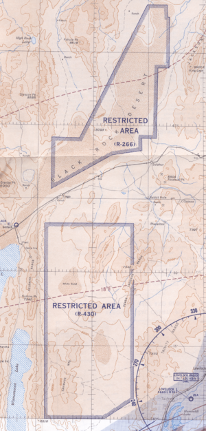
1955 map of "U. S. Prohibited, Restricted, Caution and Warning Areas on Elko Sectional Chart": "Black Rock Desert" (R-266) and "Sahwave Mountains" (R-430)
|
|
| Country | United States |
| State | Nevada |
| Counties | North: Pershing South: Humboldt |
| Years | 1945–1963 |
| Area | |
| • Total | 0 sq mi (0 km2) |
The Lovelock Aerial Gunnery Range was a special training area in Nevada, USA. It was used during World War II to help pilots practice their flying and shooting skills. Pilots learned how to:
- Shoot at targets from the air (aerial gunnery)
- Attack ground targets with machine guns (strafing)
- Drop bombs from high up (dive bombing)
- Fire rockets
This range was approved in late 1944 for the Naval Air Station Fallon. Training began in January 1945. The land for the range was rented from private owners and the government. It was divided into two main parts: the North Range and the South Range.
After World War II ended, the range was used again in October 1945. The United States Navy closed over 1,563 square miles (4,048 km2) of land to the public. This was to keep people safe from the ongoing training. However, the permits for the range were cancelled in 1946 and 1947, and the area was eventually closed.
Black Rock Desert Training Area
The Black Rock Desert was a large area used for training during World War II. It covered about 973 square miles (2,520 km2). The United States Army Air Forces used it for aerial gunnery practice.
Later, in 1949, the Navy reactivated a part of this area. It was about 745 square miles (1,930 km2) and was near Sulphur, Nevada. This area was known as the Black Rock Desert Gunnery Range. It was finally closed by 1964.
Sahwave Mountain Air-to-Air Gunnery Range
In 1958, the southern part of the original Lovelock range was renamed. It became the Sahwave Mountain Air-to-Air Gunnery Range. This large area was about 547,906 acres (2,217 km2). It was mainly used for machine gun practice between planes in the air.
An interesting event happened here in 1976. A Lockheed SR-71 Blackbird spy plane crashed near Lovelock during a night training flight. Luckily, both the pilot and the other crew member were able to eject safely from the plane.

