
Image: Blaeu Americae Nova Tabula 1614 (1617) UTA
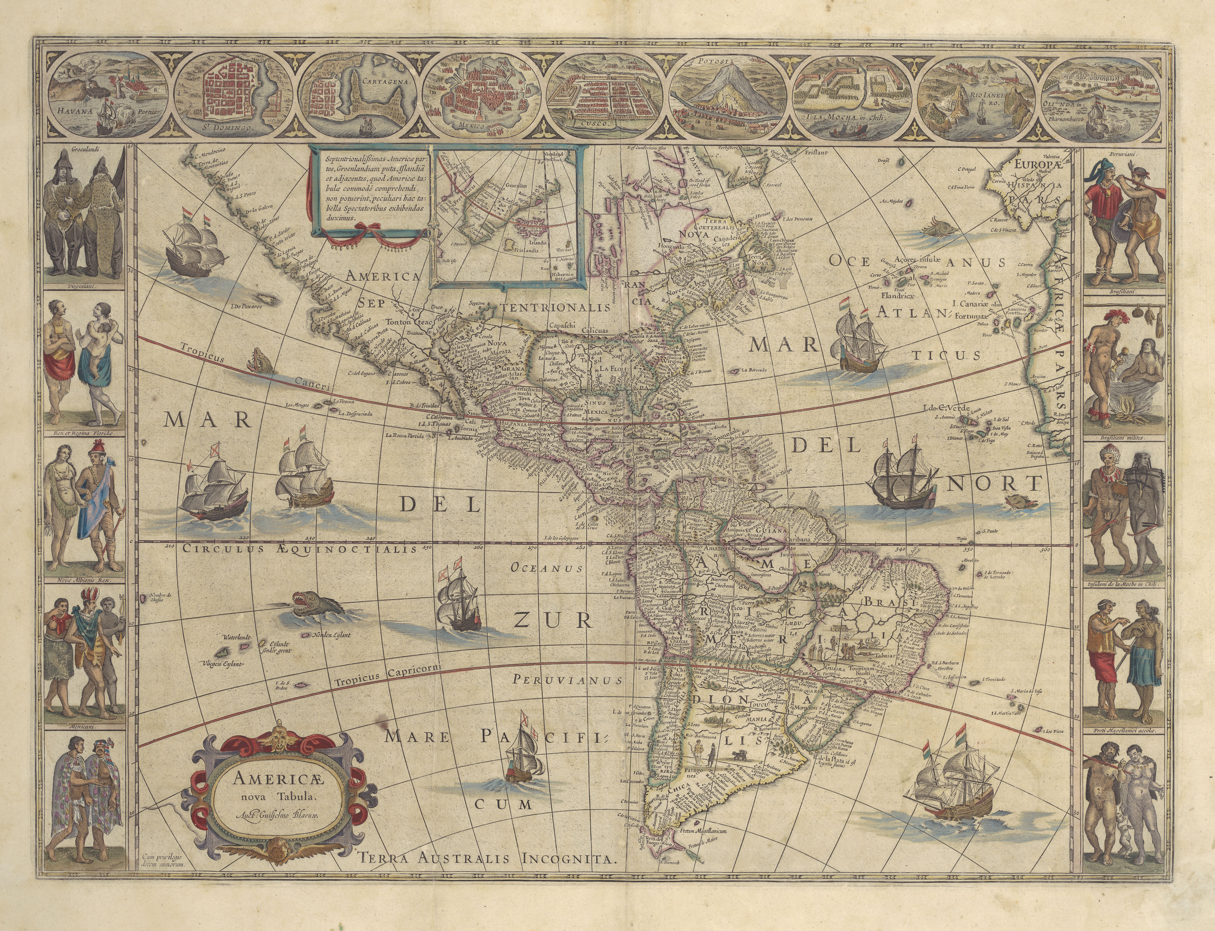
Description: Famous as a decorative example of Dutch cartography, Blaeu's single-sheet general map of America has many connections to chartered companies. In addition to the Blaeu family's important status as map suppliers for the VOC and the WIC, the map itself contains references to various European company-funded discoveries. As part of the set of single-sheet general maps of the continents, it regularly appeared in Blaeu atlases from 1617 onward with few corrections. The map was one of the first popular maps to show the bay where Henry Hudson was cast adrift in 1611 on his last voyage which was funded by the Virginia and East India Companies of England. It also attempted to visualize some of the eastern Great Lakes up the St. Lawrence where a few French chartered companies sought to trade. Blaeu's map shows Tierra del Fuego at the tip of South America as an island, although the rare first state of the map issued in 1617 had shown it attached to a southern landmass labeled "Terra Australis Incognita". A Dutch expedition under Willem Cornelisz Schouten and Jacob le Maire had just circumnavigated the world in 1615-1616 and had discovered a new passage (Strait of Le Maire, shown on the map as Fretum le Maire) south of Magellan's strait, which proved that Tierra del Fuego was an island. This expedition was funded by the Australian Company, a short-lived Dutch rival to the VOC. Lawsuits between this company and the VOC had prevented Blaeu, who was sworn to secrecy, from incorporating the information on his 1617 map. In several cases, the decorative illustrations on and around the map also relate to chartered companies. Early Dutch expeditions sent by precursor companies of the VOC frequented Mocha Island off the coast of Chile and Olinda in Pernambuco, Brazil, seen in a couple of the vignettes at the upper left. By the 1630s the WIC effectively controlled some of these areas, if only temporarily. Throughout the map itself a number of East India merchantmen fly the Dutch tri-color. A simplified version of the Cross of Burgundy flag used by the Spanish as a naval ensign, for overseas territories, and as a battle flag signifies rival vessels.
Title: Americae Nova Tabula
Credit: UTA Libraries Cartographic Connections: map / text
Author: Willem Blaeu
Usage Terms: Public domain
License: Public domain
Attribution Required?: No
Image usage
The following page links to this image:

_UTA.jpg)