
Image: Borders proposed by the Count of Aranda

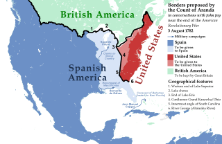
Description: North American borders proposed by the Count of Aranda in conversations with John Jay near the end of the American Revolutionary War, 3 August 1782
Title: Borders proposed by the Count of Aranda
Credit: Sources: BASE MAP: File:United_States_(US49+1),_administrative_divisions_-_XY.svg Negotiations for Peace (Complete Map), 1779-1783 [PLATE 89], Atlas of the Historical Geography of the United States http://dsl.richmond.edu/historicalatlas/89/ See Line 5. The Rayneval Memoranda of 1782 on western boundaries and some comments on the French historian Doniol, by Samuel Flagg Bemis. American Antiquarian Society, April 1937 https://www.americanantiquarian.org/proceedings/44806951.pdf "Let us start at the western end of Lake Superior and follow the lake shores along as far as the end of Lake Erie or Oswego. These are positions which cannot leave lands back of them in dispute." [...] "Now we will drop the line down to the confluence of the Grand Kanawha with the Ohio," he continued, "thence to the apex of the innermost [i.e. westernmost] angle of South Carolina, so as to continue the demarcation toward some outstanding point, say a lake [Ou the Mitchell's Map used by the negotiators there is single lake near the boundary of East Florida, about 83° west longitude.], in the Apalache country, or the river George [the Altamaha river], without however going all the way, simply marking the beginning of the line so as to indicate it would go that way. We would have to stop before we get to the boundary of Georgia or of Florida until we know what their real boundaries are." Altamaha River is chosen in this representation. Pouré, Gálvez and Cajigal expeditions are shown due to their influence on the Spanish proposal. Rupert's Land claimed border is also represented (Hudson Bay watershed) and taken as the Spanish-British border. British America-US border is shown as in many other representations of the early US.
Author: Nagihuin
Usage Terms: Creative Commons Zero, Public Domain Dedication
License: CC0
License Link: http://creativecommons.org/publicdomain/zero/1.0/deed.en
Attribution Required?: No
Image usage
The following 2 pages link to this image:
