
Image: Boston 1772

Size of this preview: 651 × 599 pixels. Other resolutions: 261 × 240 pixels | 1,536 × 1,414 pixels.
Original image (1,536 × 1,414 pixels, file size: 268 KB, MIME type: image/png)
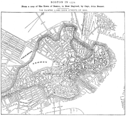
Description: "Boston in 1772. From a map of The Town of Boston, in New England, by Capt. John Bonner" "The fainter lines show streets of 1880." From Report on the Social Statistics of Cities, Compiled by George E. Waring, Jr., United States. Census Office, Part I, 1886. Edited version of University of Texas image.http://www.lib.utexas.edu/maps/historic_us_cities.html "No permissions are needed to copy them. You may download them and use them as you wish."http://www.lib.utexas.edu/usage_statement.html?maps=yes
Title: Boston 1772
Usage Terms: Public domain
License: Public domain
Attribution Required?: No
Image usage
The following page links to this image:

All content from Kiddle encyclopedia articles (including the article images and facts) can be freely used under Attribution-ShareAlike license, unless stated otherwise.