
Image: Butterfield-Overland
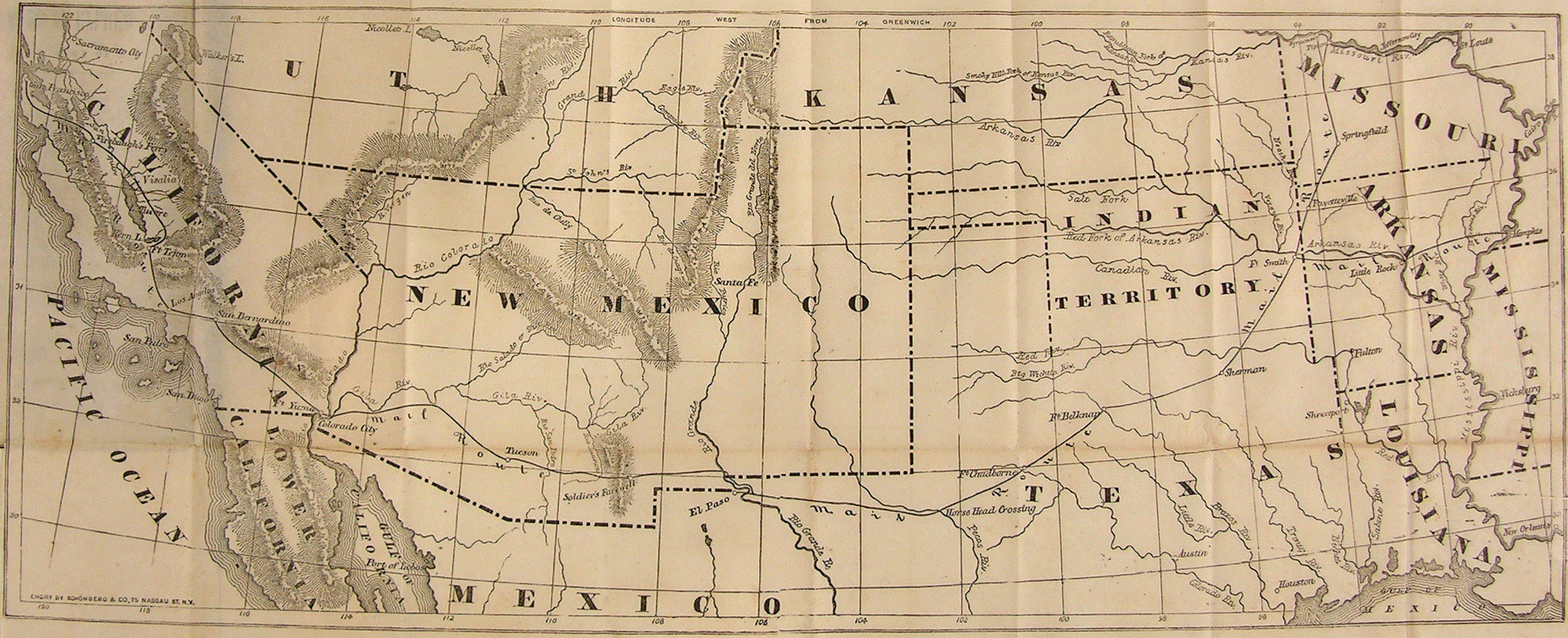
Description: Foldout map of the Southwestern United States with territories and "Mail Route" of the Overland Mail Company contracted for $600,000 per year in 1857. Service began when the "first eastbound stagecoach departed San Francisco on September 15, 1858, and the westbound stagecoach left St. Louis a day later." The "DAILY LINE, from St.Louis to Springfield, Mo." was through en:Tipton, Missouri until the tbd railway was extended in 1859 along the preceding stage route to "The George Shackelford Relay and Meal Station" in en:Syracuse, Missouri. The "southern route" through the 1854 Gadsden Purchase region was abandoned in 1861 for the central route through the Kansas and Utah Territories (former Pony Express Route, not shown). ERRATA The serpentine line indicating an overland route between Fort Smith and Little Rock was via an Arkansas River "SEMI-WEEKLY LINE of STEAMERS carrying mail, freight, and passengers". Lake Tahoe (not labeled) is not depicted on the California/Utah territories' lines (later the California/Nevada state lines) "Wasatch Mountains" is depicted as a much larger part of the Great Basin Divide, extending from the Utah Territory, into the New Mexico T, and ending in California's Mojave Desert "Nicolette L" with the inflow "Nicolett Riv" having the same shape as the Spanish Fork River (into Utah Lake) is shown near 114 degW rather than 111 deg W "Sierra Madre NAMES Features without labels: Sevier Lake/Sevier River, Outdated names (current name displays in popup): Grand Riv., Los Angelos, Rio Colorado/San Joaquin/, Sacramento City, Walker's L.
Title: Butterfield-Overland
Credit: 19th Century cartography: "ENGRD BY SCHÖNBERG & CO, 75 NASSAU ST. N.Y." (the Overland Mail Company's "Principal Office, in New York [was] at the American Express Building, Hudson, Jay and Staple Streets".) modern computerization (685 KB file timestamped 11/22/1985 8:56 AM) by National Postal Museum from the c. 1858-9 handbook "printed by Hellier and Company Publishers" for "conducters, agents, drivers, and station managers" and, in addition to the foldout map, an "Almanac for 1859" and a "Through Time Schedule (No. 2, Jan 1859)". blurry 102KB image: previously uploaded 16 June 2010 (original upload date) to en.wikipedia.org by en:User Zeamays from http://www.postalmuseum.si.edu/museum/1d_Butterfield.html legible 685 KB image: National Postal Museum file 1990_0564_1-MAP-02.JPG
Author: author produced map prior to 1923
Permission: This work is in the public domain in its country of origin and other countries and areas where the copyright term is the author's life plus 70 years or less. You must also include a United States public domain tag to indicate why this work is in the public domain in the United States. Note that a few countries have copyright terms longer than 70 years: Mexico has 100 years, Jamaica has 95 years, Colombia has 80 years, and Guatemala and Samoa have 75 years. This image may not be in the public domain in these countries, which moreover do not implement the rule of the shorter term. Côte d'Ivoire has a general copyright term of 99 years and Honduras has 75 years, but they do implement the rule of the shorter term. Copyright may extend on works created by French who died for France in World War II (more information), Russians who served in the Eastern Front of World War II (known as the Great Patriotic War in Russia) and posthumously rehabilitated victims of Soviet repressions (more information). This file has been identified as being free of known restrictions under copyright law, including all related and neighboring rights.
Usage Terms: Public domain
License: Public domain
Attribution Required?: No
Image usage
The following 2 pages link to this image:
