
Image: California and Mexico Steamship Company line map, from- Old Mexico and her lost provinces; a journey in Mexico, southern California, and Arizona, by way of Cuba (1883) (14594814447) (cropped)

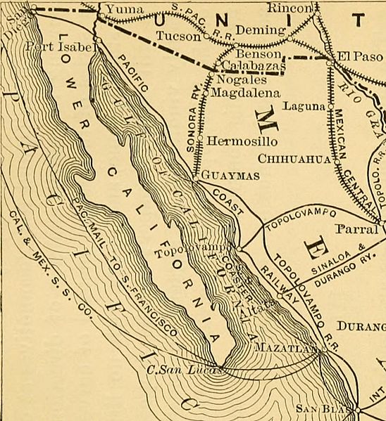
Description: Identifier: oldmexicoherlost1883bish (find matches) Title: Old Mexico and her lost provinces; a journey in Mexico, southern California, and Arizona, by way of Cuba Year: 1883 (1880s) Authors: Bishop, William Henry, 1847-1928 Subjects: Mexico -- Description and travel California -- Description and travel Arizona -- Description and travel Publisher: New York, Harper & brothers Contributing Library: Brown University Library Digitizing Sponsor: Brown University View Book Page: Book Viewer About This Book: Catalog Entry View All Images: All Images From Book Click here to view book online to see this illustration in context in a browseable online version of this book. Text Appearing Before Image: n Southern (General Grant, President) 1,000 Oriental (De Gress and Jay Gould) 1,200 Topolobambo (Senator Windom, President) 1,200 International (Frisbie and Huntington) 1,400 Pacific Coast (Frisbie) 3,000 Total 12,300 To these may be added the Sinaloa and Darango, fromthe city of Culiacan to the port of Altata, in Sinaloa; theTehuantepec railway, and Captain Eadss ship railwayacross the same isthmus, to take the place of a ship canal.The privilege to build an American railway across Te-huantepec, it may be remembered, was secured (at thesame time with the lower belt of Arizona) by the Gads-den treaty of 1853, supplementary to that of GuadalupeHidalgo. The road was supposed to be needed for theconsolidation of relations with our then newly acquiredterritory of California. The Pacific railroad filled itsplace, however, and the project, taken up and droppedfrom time to time, has since had but a lingering existence. Captain Eads proposes to transport bodily ships of THE FERRO-CARRILES. 75 Text Appearing After Image: 76 OLD MEXICO AND HER LOST PROVINCES. 4000 tons, 190 miles, by land. He will Lave twelvelines of rails, and four locomotives at once; and, to avoidjarring in transit, changes of direction will be made bya series of turn-tables instead of curves. The scheme isa startling one, and meets with no little opposition. Itis still only on paper; but its proposer, who has abun-dantly vindicated his sagacity in constructing the jettiesof the Mississippi and the great St. Louis bridge, remainsfirm in his conviction that he will be able to sail shipsacross the isthmus on dry land. III. The several enterprises are succinctly divided into twoclasses—those on the ground, and those on paper. It isnot necessarily a disparagement to the last that they arestill in such a condition, for many of them are of veryrecent origin. The original Mexican Southern road is to rim southfrom Mexico, by Puebla and Oaxaca (capital of the pop-ulous state of the same name) and the frontier of Gua-temala, with branches t Note About Images Please note that these images are extracted from scanned page images that may have been digitally enhanced for readability - coloration and appearance of these illustrations may not perfectly resemble the original work.
Title: California and Mexico Steamship Company line map, from- Old Mexico and her lost provinces; a journey in Mexico, southern California, and Arizona, by way of Cuba (1883) (14594814447) (cropped)
Credit: https://www.flickr.com/photos/internetarchivebookimages/14594814447/ Source book page: https://archive.org/stream/oldmexicoherlost1883bish/oldmexicoherlost1883bish#page/n92/mode/1up
Author: Bishop, William Henry, 1847-1928
Permission: At the time of upload, the image license was automatically confirmed using the Flickr API. For more information see Flickr API detail.
Usage Terms: No known copyright restrictions
License: No restrictions
License Link: https://www.flickr.com/commons/usage/
Attribution Required?: No
Image usage
The following page links to this image:

_(14594814447)_(cropped).jpg)