
Image: Camden Fort Meagher Cork Harbour Rough Plan

Size of this preview: 793 × 599 pixels. Other resolutions: 318 × 240 pixels | 1,143 × 864 pixels.
Original image (1,143 × 864 pixels, file size: 62 KB, MIME type: image/png)
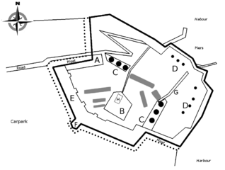
Description: Rough outline plan of headland and fort of Camden Fort Meagher in Cork Harbour. Hand drawn using 19th century map (and own knowledge) as simple guide. NOT intended to be 100% accurate or to scale. Features: A - Barracks B - Square C - Upper Batteries D - Lower Batteries E - Terreplein and Ramparts F - Caponier G - "Bright Tunnel" H - Underground Magazine
Title: Camden Fort Meagher Cork Harbour Rough Plan
Credit: Own work
Author: Guliolopez
Usage Terms: Creative Commons Attribution-Share Alike 3.0
License: CC BY-SA 3.0
License Link: https://creativecommons.org/licenses/by-sa/3.0
Attribution Required?: Yes
Image usage
The following page links to this image:

All content from Kiddle encyclopedia articles (including the article images and facts) can be freely used under Attribution-ShareAlike license, unless stated otherwise.