
Camden Fort Meagher facts for kids
Quick facts for kids Camden Fort Meagher |
|
|---|---|
| Near Crosshaven in County Cork in Ireland | |

Landward wall and moat of Fort Camden
|
|

Camden Fort Meagher
|
|
| Coordinates | 51°48′29″N 8°16′44″W / 51.808°N 8.279°W |
| Type | Coastal defence fortification |
| Site information | |
| Owner | Cork County Council |
| Open to the public |
Yes (seasonal, weekends) |
| Condition | Largely restored |
| Site history | |
| Built | 1550 (original structure) 1860s (significant reconstruction) |
| In use | 1980s (demilitarisation) |
| Events | Siege of Kinsale (1601), Williamite War in Ireland (1690), Brennan torpedo installation (1891), Treaty Port handover (1938) |
| Garrison information | |
| Occupants | British Armed Forces, Irish Defence Forces |
Camden Fort Meagher is an old fort near Crosshaven, County Cork, Ireland. It was built to protect the entrance to Cork Harbour. This fort, along with others like Fort Mitchell on Spike Island and Fort Davis in Whitegate, helped guard the harbour.
While the first fort here was built in the 1500s, most of what you see today was built in the 1860s. It was first called Fort Camden and was used by the British Armed Forces. In 1938, it was given to the Irish Defence Forces. They renamed it Fort Meagher to honour Thomas Francis Meagher.
The fort remained a military base until 1989. Then, the Irish Army gave it to Cork County Council. For a while, it became overgrown and forgotten. But in 2010, local volunteers started to restore it. They wanted to open it for visitors. The fort was then renamed Camden Fort Meagher. Today, it's open seasonally, offering exhibits about its history, including the Brennan torpedo. This torpedo was the world's first "practical guided weapon."
Contents
History of Camden Fort Meagher
Early Defences and Wars
The land where the fort stands is called Ram's Head. It looks over Cork Harbour, which is one of the biggest natural harbours in the world. This made it very important for defence and navies throughout history.
The first defences were built here in 1550. They were known as James' Battery. The fort was made bigger in 1600. But it wasn't used much after the Nine Years' War.
In 1690, the fort was strengthened again. This was to help defend Cork Harbour during the Williamite War in Ireland. However, enemy soldiers secretly landed and captured the fort from the land side. Later, the ports of Cork and Kinsale were taken by forces led by the Duke of Marlborough.
Fort Camden and Major Upgrades
By the time of the Napoleonic War (around 1779), the defences were called the Ram's Head Battery. They were improved and rebuilt to work with other forts nearby. These included forts at Haulbowline, Spike Island, and Whitegate. In 1795, these forts were named Fort Camden. This was in honour of John Pratt, 1st Marquess Camden, who was then the leader of Ireland.
By the 1830s, Fort Camden had only a small number of soldiers. For a short time, it was even used as a prison. But in the 1850s, a special group looked at the harbour's importance again. They suggested big improvements to the fort's land and sea defences.
Building work started in 1861. Convicts, soldiers, and regular workers helped build it. The fort was made much larger during this time. Many parts of the fort were built underground. Most of the fort's structures you see today are from these building projects.
Modernisation and Handover
In the 1880s and 1890s, the guns at the fort were updated. Newer, larger cannons were put in place. A minefield was also placed across the channel. A special launching spot was added for the "Brennan Torpedo". This was called the "world's first practical guided weapon."
During the First World War, Cork Harbour was used as a naval base. It helped protect ships in the "Western Approaches" (the sea lanes west of Britain and Ireland). An anti-submarine net was added, and the harbour defences were improved further.
After the Irish War of Independence, the Anglo-Irish Treaty meant that the British government kept control of some harbour defences. These were called Treaty Port installations. Fort Camden was one of them. In July 1938, these forts were handed over to the Irish authorities.
During "the Emergency" (1939–1945), which was Ireland's name for World War II, Irish soldiers used the fort. They were part of the Coastal Defence Artillery.
The fort was later renamed Fort Meagher. This was to honour Thomas Francis Meagher, who was involved in a fight for Irish independence in 1848. Other forts were also renamed at this time.
By the mid- to late-1900s, the fort was mainly used for training. It trained members of the Civil Defence and Reserve Defence Forces. In the 1980s, the army gave the fort to Cork County Council. The fort then became unused and overgrown for many years.
In 2010, people from Crosshaven started a volunteer project. They worked to clear and restore the fort. Their goal was to turn it into a place for history and tourism.
Features of the Fort
The fort's main features come from its development in the 1800s. At its busiest, the fort had 7 officers, over 200 soldiers, and more than 20 guns.
Land Defences
On the side facing the land, the fort had many defences. These included a ditch, ramparts, and special areas for guns. There was also a caponier and other gun positions. These all helped protect the fort from attacks by land.
The barracks building was in the north-east corner. It was close to the land entrance. This building housed the soldiers and helped control the land defences. The barracks looked over the road that enters the fort. This road crosses a bridge over the dry moat.
The moat was very wide, about 28 feet (8.5 meters) in some places. It was covered by two levels of gun positions. A two-storied caponier also had spots for landward gunners. On the ramparts, there was a terreplein. This area had several movable cannons. These cannons were supported by fixed magazines (places to store ammunition). They could fire at enemies approaching from the land. In 1898, the land defences had four large 32-pounder guns.
Sea Defences
On the side facing the sea, there were land batteries. These batteries had guns pointed at the harbour. There were upper and lower batteries. The lower batteries had 10 gun positions. These were behind shields along the sea front.
The upper batteries had three guns on the left and three on the right. In 1898, the upper batteries had two large 6-inch guns. They also had five 12-pounder guns. Smaller 6-pounder guns were in the lower batteries.
Torpedo Station and Tunnels
A Brennan Torpedo station was built at the waterfront in the 1890s. A second torpedo slipway was added after 1900. The fort also had two piers for boats to access it.
In the middle of the fort, a spiral staircase goes down from the parade ground. It leads to the main powder magazine. This is a large, vaulted room where gunpowder was stored. A tunnel connects this main magazine to the lower batteries.
The area where the soldiers lived connects to the lower batteries and piers. This is done by a zigzag path to the west. The upper batteries and parade ground also link to the lower areas. This link is through a tunnel to the east, known as the "bright tunnel."
Images for kids
-
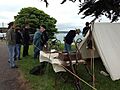
Historical reenactors on the fort's parade ground
-
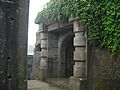
Gateway from the pier area to the lower courtyard
-
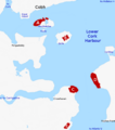
Map of lower harbour showing fort locations: (A) Haulbowline Naval Base, (B) Fort Mitchel/Westmoreland, (C) Fort Meagher/Camden, (D) Fort Davis/Carlisle, (E) Fort Templebreedy
-
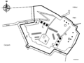
Plan with key features: (A) Barracks, (B) Square, (C) Upper batteries, (D) Lower batteries, (E) Terreplein, (F) Caponier, (G) Bright Tunnel, (H) Main magazine


