
Haulbowline facts for kids
|
Native name:
Inis Sionnach
|
|
|---|---|

Aerial view with Naval Base to west (right), industrial site to east (left) & dockyard (centre)
|
|

Haulbowline Island
Location in island of Ireland
|
|
| Geography | |
| Location | County Cork, Ireland |
| Coordinates | 51°50.5′N 8°18′W / 51.8417°N 8.300°W |
| Area | 35 ha (86 acres) |
| Administration | |
| Province | Munster |
| County | Cork |
| Water body | Cork Harbour |
Haulbowline (which in Irish is Inis Sionnach) is an island located in Cork Harbour, off the coast of Ireland. It's a really important place! The world's first yacht club was started here way back in 1720.
Today, the western part of Haulbowline Island is the main base for the Irish Naval Service. This is where Ireland's navy has its headquarters. The eastern side of the island used to be a place for big factories. Since 1966, a road bridge has connected the island to the mainland.
Contents
What's in a Name? The Meaning of Haulbowline
The name Haulbowline might come from an old language called Old Norse. It could mean "eel dwelling," which suggests it was a place where lots of conger eels lived.
In the 17th and 18th centuries, people spelled the name with "-ing" at the end. Later, sailors might have changed the spelling. The Irish name for the island, Inis Sionnach, means "island of the foxes."
Haulbowline's Military Past: A Strategic Island Base
Haulbowline Island has always been a key military spot. This is because of its great location in the harbour with deep water. The island was first made into a fort in 1602. It was an important base for the British Army at that time.
In 1603, some leaders in Cork city were accused of trying to destroy the fort. A judge named William Meade was even charged with treason because of it.
The World's First Yacht Club
In 1720, a group called the Cork Water Club owned much of the island. This club later became the Royal Cork Yacht Club. It is known as the world's first yacht club! They even had a castle on the island that they used as their clubhouse.
Changes in Military Control
In 1806, the British Army moved to nearby Spike Island. The forts on Haulbowline were then given to others. About 14 acres of land went to the Royal Navy. The remaining 8 acres went to the Board of Ordnance. Back then, the island was less than half its current size.

An Ordnance Yard was built on the western side of the island. It was separated by a large stone wall. A Martello tower was also built to help defend the island. In 1808, two large buildings for storing gunpowder were put up on nearby Rocky Island. They could hold 25,000 barrels of gunpowder!
East of the wall, a Victualling Yard was created. From 1807 to 1824, many buildings were constructed there. Some of these buildings are still standing today. The most noticeable are six large storehouses. Three are around a quay on the north side. Three others were along the island's eastern edge.
Behind these buildings was a big tank to collect fresh rainwater for ships. On top of this tank was a large area for making barrels. To the south, there was a store for masts and boats. Cottages and houses for workers were built along the wall. At this time, about 4 acres were added to the island by reclaiming land from the sea. This was the first of many such additions.

Even after all this building, the Navy decided to close the Yard in 1831. But it reopened ten years later! The next big change happened in the 1860s. A Royal Navy Dockyard was set up on Haulbowline. This dockyard was for repairing and building warships.
To make space for this new industrial area, the island was made twice as big. It grew to about 60 acres. A large basin was built, which now divides the island. It had a 408-foot dry dock at one end. This dry dock was made even longer, to 600 feet, just before the First World War. By the 1900s, the Royal Alexandra Victualling Yard also had a place to refuel ships. There was also a naval hospital in one of the old storehouses.
Haulbowline in Modern Times
In June 1940, an Irish Marine and Coastwatching Service boat returned to Haulbowline. It had made two trips to rescue French and British soldiers during the Dunkirk evacuation.

Haulbowline was different from other forts in Cork Harbour. Those forts were part of the treaty ports and stayed under British control for longer. But the dockyard on Haulbowline was given to the Irish Free State in 1923. It has been the main naval base and headquarters for the Irish Naval Service ever since.
Most of the Naval Service campus is on the west side of the island. This includes much of the old Ordnance Yard. The service's football pitch was built on land reclaimed from the eastern side in the 1980s. In September 2014, the Minister for Defence, Simon Coveney, announced plans for a €50 million upgrade. This upgrade would improve the quays for the Naval Service's new ships. It would also build a runway for the Naval Service to use UAV drones.
In March 2008, one of the historic 19th-century storehouses on Haulbowline Island was destroyed by fire. Only its walls were left standing.
Images for kids
-
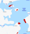
Plan of lower harbour showing Naval Base relative to other installations: (A) Haulbowline Naval Base, (B) Fort Mitchel/Westmoreland, (C) Fort Meagher/Camden, (D) Fort Davis/Carlisle, (E) Fort Templebreedy
-

Planting in Haulbowline Island Amenity Park


