
Spike Island, County Cork facts for kids
|
Native name:
Inis Pic
|
|
|---|---|

Gates of Fort Mitchel on Spike Island
|
|

Spike Island
Location in island of Ireland
Spike Island in Ireland
|
|
| Geography | |
| Location | Cork Harbour |
| Coordinates | 51°50′05″N 8°17′11″W / 51.8347°N 8.2864°W |
| Area | 0.41 km2 (0.16 sq mi) |
| Length | 0.8 km (0.5 mi) |
| Width | 0.5 km (0.31 mi) |
| Administration | |
| County | County Cork |
Spike Island (which is called Inis Píc in Irish) is an island in Cork Harbour, Ireland. It's about 103 acres big. Long ago, it was home to a group of monks. Today, the island is mostly covered by a large 18th-century fort, now known as Fort Mitchel.
Because of its great location in the harbour, Spike Island was used for defending the area and also as a prison. In recent years, the island has become a popular place for tourists to visit. Over €5.5 million has been spent to create cool exhibits and visitor areas. In 2019, more than 81,000 people visited the island. Spike Island was even named the best European tourist attraction in 2017!
The Story of Spike Island
Spike Island has a long and interesting past, from ancient times to its role as a famous prison and now a top tourist spot.
Early Days: Monks and Old Buildings
It's believed that a group of monks lived on Spike Island a very long time ago. Some old writings suggest that Saint Mochuada started a monastery there in the 600s. Another old document from 1178 mentions a church on the island, which might mean a Celtic monastery was there. In 1774, people reported seeing the ruins of a church on Spike Island.
Who Owned the Island?
After the Normans arrived in Ireland, Spike Island changed hands many times. In 1178, a king named Diarmid McCarthy gave up lands, including Spike Island, to the Normans. Soon after, a man named Raymond Mangunel was given the island.
Later, in the 1400s, the Pyke family owned the island. Then, in the 1600s, the Roche and Galwey families had it. However, they lost the island during a rebellion in 1641. Even when King Charles II came back to power, they didn't get it back.
By 1698, the island belonged to Arnold Joost van Keppel, who came to England with William of Orange. He then sold it to William Smith. In the 1770s, Nicholas Fitton owned it. The government started renting parts of the island to build forts, and eventually, they rented the whole island.
Military Use and Forts

Spike Island's location at the entrance of Cork Harbour made it very important for defense. Around 1600, maps even showed a fortified tower on the island.
First Forts: Protecting the Harbour
The first fort on Spike Island was built in 1779. This happened because of the American Revolution, when France and Spain joined the war against Britain. Cork Harbour was a busy place where many ships gathered before sailing to America. It also supplied British forces. So, protecting the harbour was very important.
The first fort was a temporary one, armed with 18 cannons. When the war ended in 1783, this temporary fort was taken down.
Building Fort Westmorland
In 1789, Colonel Charles Vallancey convinced the Lord Lieutenant, John Fane, to build a permanent fort on Spike Island. This new fort was named Fort Westmorland. Building started, but it was slow. By 1802, the fort was finished. It had many cannons, including 29 large 24-pounder guns.
A New, Bigger Fortress
The military worried about two main threats to Cork Harbour: enemy warships trying to enter, or enemy soldiers landing on the coast and attacking from land. In 1796, the French tried to land 15,000 soldiers at Bantry Bay, which was very close to Cork. This made the military very worried.

In 1802, military leaders decided that a much bigger fortress was needed on Spike Island. They thought it was the "true point of defense" for Cork Harbour. This new fort would be able to hold 2,000 to 3,000 soldiers.
Building the new fortress began in 1804. The island's height was even lowered by 25 feet to create a flat area for the fort. A large number of workers, both soldiers and civilians, helped build it. The fort included strong, bombproof rooms for soldiers to live in, as well as storage areas for ammunition.
Later Uses: Prison and Handover
Spike Island later became a famous prison and a place where convicts were held before being sent to other countries. It opened in 1847 because many people were being arrested for theft during the Great Famine. For a few years in the mid-1800s, it was probably the biggest prison in the British Empire. It even earned the nickname "Ireland's Alcatraz".
A young girl named Ellen Organ lived on the island and received special permission to take her First Communion before she died at age 4. Her story led the Pope to lower the age for First Communion from 12 to 7.
The island continued to be used as a military base and prison during the Irish War of Independence. Many Irish prisoners were held there. Richard Barrett, an Irish Republican, was one of them, but he managed to escape in 1921. Over 1,400 men were held on the island at its busiest time.
Handover to Ireland
.jpg)
After the Anglo-Irish Treaty was signed in 1921, the Irish Free State was formed. However, the British kept control of three important ports, called the Treaty ports. Spike Island was one of these. This meant the Royal Navy stayed on the island even after Ireland became independent.
Finally, on July 11, 1938, Spike Island was given back to Ireland. Important Irish leaders, like Éamon de Valera, attended the handover ceremony.
Spike Island Since 1938

After being handed over to Ireland, the island's fort was renamed Fort Mitchel, in honor of John Mitchel, a nationalist who was once held there. Other forts in Cork Harbour were also renamed.
Spike Island remained a prison and a military base for the Irish Army and later the Navy. In the late 20th century, it was used as a facility for young offenders. In 1985, there was a riot where inmates set fire to one of the buildings, known as the Burnt Block. This prison closed in 2004.
The island also had a small number of people living there, with a school, church, and ferry service to Cobh. However, these civilians have since moved off the island, with many going to nearby Cobh.
Population Changes
The number of people living on Spike Island has changed a lot over time. Here's a look at how the population has grown and shrunk:
| Historical population | ||||||||||||||||||||||||||||||||||||||||||||||||||||||||||||||||||||||||||||||||
|---|---|---|---|---|---|---|---|---|---|---|---|---|---|---|---|---|---|---|---|---|---|---|---|---|---|---|---|---|---|---|---|---|---|---|---|---|---|---|---|---|---|---|---|---|---|---|---|---|---|---|---|---|---|---|---|---|---|---|---|---|---|---|---|---|---|---|---|---|---|---|---|---|---|---|---|---|---|---|---|---|
|
|
|
||||||||||||||||||||||||||||||||||||||||||||||||||||||||||||||||||||||||||||||
| Source: | ||||||||||||||||||||||||||||||||||||||||||||||||||||||||||||||||||||||||||||||||
Images for kids
-
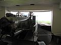
A large six-inch coastal defense gun inside the fort.

