
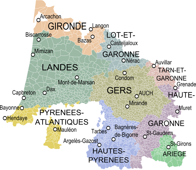
Image: Carte de la Gascogne

Description: Map of the old province of Gascony, France, showing the communes according to the current administrative division.
Title: Carte de la Gascogne
Credit: Partie méridi[ona]le du gouvernement de Guienne où se trouvent le Condomois, la Chalosse, le pays de Soule, le Labour, l'Armagnac, les Landes, le Cominge, le Bigorre, le Conserans etc ; Gouvernement de Basse Navarre et Bearn, Robert de Vaugondy. Carte du Bearn de la Bigorre, de l'Armagnac et des Pays Voisins, Delisle. Définition de la frontière Guyenne/Gascogne selon Expilly (Gascogne = sud du Bordelais et du Bazadais).Derivative works of this file: Blank Map of Ariège Department, France, with Communes.svg by Poulpy Derivative works of this file: Blank Map of Haute-Garonne Department, France, with Communes.svg by Poulpy Derivative works of this file: Blank Map of Gers Department, France, with Communes.svg by Poulpy Derivative works of this file: Blank Map of Hautes-Pyrénées Department, France, with Communes.svg by Poulpy Derivative works of this file: Blank Map of Pyrénées-Atlantiques Department, France, with Communes.svg by Poulpy Derivative works of this file: Blank Map of Lot-et-Garonne Department, France, with Communes.svg by Poulpy Derivative works of this file: Blank Map of Tarn-et-Garonne Department, France, with Communes.svg by Poulpy Derivative works of this file: Blank Map of Landes Department, France, with Communes.svg by Poulpy Derivative works of this file: Blank Map of Gironde Department, France, with Communes.svg by Poulpy
Author: Oie blanche
Usage Terms: Creative Commons Attribution-Share Alike 3.0
License: CC BY-SA 3.0
License Link: https://creativecommons.org/licenses/by-sa/3.0
Attribution Required?: Yes
Image usage
The following page links to this image:
