
Image: Cartier Second Voyage Map 1

Size of this preview: 800 × 546 pixels. Other resolutions: 320 × 218 pixels | 831 × 567 pixels.
Original image (831 × 567 pixels, file size: 103 KB, MIME type: image/png)
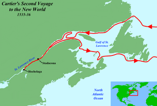
Description: Map of Jacques Cartier's second voyage to North America in 1535-6.
Title: Cartier Second Voyage Map 1
Credit: Base maps used: File:Topographic30deg N30W60.png and File:Topographic30deg N30W30.png by User:Koba-chan. World locator map by User:Redeemer is from here:File:BlankMap-World2.png. Remaining work was by AlexiusHoratius.
Author: Jon Platek
Usage Terms: Creative Commons Attribution-Share Alike 3.0
License: CC BY-SA 3.0
License Link: http://creativecommons.org/licenses/by-sa/3.0
Attribution Required?: Yes
Image usage
The following 2 pages link to this image:

All content from Kiddle encyclopedia articles (including the article images and facts) can be freely used under Attribution-ShareAlike license, unless stated otherwise.