
Image: Charente-Maritime et provinces

Size of this PNG preview of this SVG file: 512 × 599 pixels. Other resolution: 205 × 240 pixels.
Original image (SVG file, nominally 1,000 × 1,170 pixels, file size: 446 KB)
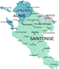
Description: Map showing the French department of Charente-Maritime and the former provinces that existed before 1790.
Title: Charente-Maritime et provinces
Credit: Gouvernemens généraux du Poitou, du pays d'Aunis, et de Saintonge-Angoumois, Robert de Vaugondy, 1753. Derivative works of this file: Blank Map of Charente-Maritime Department, France, with Communes.svg by Poulpy
Author: Oie blanche
Usage Terms: Creative Commons Attribution-Share Alike 3.0
License: CC BY-SA 3.0
License Link: http://creativecommons.org/licenses/by-sa/3.0
Attribution Required?: Yes
Image usage
The following page links to this image:

All content from Kiddle encyclopedia articles (including the article images and facts) can be freely used under Attribution-ShareAlike license, unless stated otherwise.