
Image: Chola Empire map2
No higher resolution available.
Chola_Empire_map2.png (466 × 333 pixels, file size: 85 KB, MIME type: image/png)
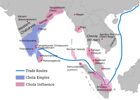
Description: Map showing the extent of the Chola empire during 10 – 11th century according to http://cw.routledge.com/textbooks/9780415485432/15.asp"THE CŌḶAS" by k. a. nilakanta sastri The file has changed from the original. The correction about the Chola influence in Malay areas is based on https://archive.org/details/earlykingdomsofi0000muno/page/118/mode/2up
The influence added the area of Lamuri based on Tanjore inscription. Andaman is deleted leaving only Nicobar (information on Tanjore inscription).
Author: Gregors
Usage Terms: Creative Commons Attribution-Share Alike 3.0
License: CC-BY-SA-3.0
License Link: http://creativecommons.org/licenses/by-sa/3.0/
Attribution Required?: Yes
Image usage
The following page links to this image:

All content from Kiddle encyclopedia articles (including the article images and facts) can be freely used under Attribution-ShareAlike license, unless stated otherwise.