
Image: Clinton-kalamazoo canal map

Size of this preview: 800 × 250 pixels. Other resolutions: 320 × 100 pixels | 3,162 × 989 pixels.
Original image (3,162 × 989 pixels, file size: 130 KB, MIME type: image/png)
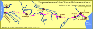
Description: Proposed route of the Clinton-Kalamazoo Canal from Lake St. Clair to Lake Michigan. Based on information in Michigan DNR Technical Report Number 92-10 published in 1992
Title: Clinton-kalamazoo canal map
Credit: Own work
Author: Otis-n
Usage Terms: Creative Commons Attribution-Share Alike 4.0
License: CC BY-SA 4.0
License Link: https://creativecommons.org/licenses/by-sa/4.0
Attribution Required?: Yes
Image usage
The following page links to this image:

All content from Kiddle encyclopedia articles (including the article images and facts) can be freely used under Attribution-ShareAlike license, unless stated otherwise.