
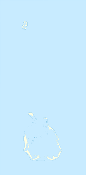
Image: Cocos (Keeling) Islands location map

Size of this PNG preview of this SVG file: 295 × 600 pixels. Other resolution: 118 × 240 pixels.
Original image (SVG file, nominally 772 × 1,569 pixels, file size: 193 KB)
Description: Location map of Cocos_(Keeling)_Islands Equirectangular projection. Geographic limits of the map: N: 11°45' S S: 12°15' S W: 96°45' E E: 97°00 E
Title: Cocos (Keeling) Islands location map
Credit: Own work
Author: Xfigpower
Usage Terms: Creative Commons Attribution 3.0
License: CC BY 3.0
License Link: https://creativecommons.org/licenses/by/3.0
Attribution Required?: Yes
Image usage
The following page links to this image:

All content from Kiddle encyclopedia articles (including the article images and facts) can be freely used under Attribution-ShareAlike license, unless stated otherwise.
_Islands_location_map.svg)