South Island, Cocos (Keeling) Islands facts for kids
|
Native name:
Malay: Pulau Atas
Cocos Malay: Pulu Atas |
|
|---|---|
 |
|
| Geography | |
| Location | Indian Ocean |
| Coordinates | 12°11′22″S 96°55′24″E / 12.18944°S 96.92333°E |
| Archipelago | Cocos (Keeling) Islands |
| Area | 3.63 km2 (1.40 sq mi) |
| Highest elevation | 9 m (30 ft) |
| Administration | |
|
Australia
|
|
| External territory of Australia | Australian Indian Ocean Territories |
| Territory | Cocos (Keeling) Islands |
| Capital city | Canberra |
| Demographics | |
| Languages | |
| Additional information | |
| Time zone | |
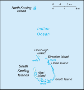
South Island (in Malay: Pulau Panjang, in Cocos Malay: Pulu Atas) is a special island. It is the southernmost and easternmost island of the Cocos (Keeling) Islands. These islands belong to Australia and are located in the eastern Indian Ocean.
South Island: A Unique Place
South Island is part of an atoll called the South Keeling Islands. An atoll is a ring-shaped coral reef, island, or chain of islands. It surrounds a lagoon. South Island is the second largest island in this group. It covers an area of about 3.63 square kilometers. The largest island is West Island.
Even though it's a big island, South Island has no people living on it. It is about 944 kilometers southwest of Enggano, an island in Indonesia. It's also about 1088 kilometers off the coast of Java. Another Australian island, Christmas Island, is about 956 kilometers to the west-northwest.
South Island is also the highest point in the Cocos (Keeling) Islands. It reaches a height of 9 meters.
What South Island Looks Like
South Island forms the southwestern edge of its atoll. This makes it very curved in shape. The side facing the open sea has a straight beach. The water there gets deep quickly.
However, the side facing the lagoon is different. It has many branches and the water stays shallow for a long way. The island is covered with thick forests.
North of South Island are nine smaller islands. The first one is Middle Mission Isle. About 4.3 kilometers further north is Home Island, where people live. Many tiny, long islands are found along the lagoon side. They are never more than 350 meters from the coast.
To the west, there are three small islands near the coast. These are North Goat Island, East Cay, and Burial Island. After them, there is a channel about 1.2 kilometers wide. Beyond this channel is another small island. The main island of West Island is about 2.3 kilometers from South Island. There might be one house on the northern part of South Island. There is also a campground to the west.
Is South Island the Southernmost Point of Asia?
The Cocos Islands are often considered part of Asia. This is because they are much closer to Indonesia than to Australia. Since South Island is the southernmost island in this group, it is sometimes called the southernmost island of Asia. Its southernmost tip, at 12° 12′ 32″ S, 96° 53′ 42″ E, could also be the southernmost point of Eurasia. Eurasia is the combined landmass of Europe and Asia.
However, if the Cocos Islands are not counted as part of Asia, then the southernmost point of Asia is on Pamana, an Indonesian island. That island is about 134 kilometers further north.
If the Australian Ashmore and Cartier Islands are also included in Asia, then the southernmost point of Asia would be on Cartier Island. This island is about 36 kilometers further south than South Island. Interestingly, the northernmost point of mainland Australia, Cape York, is about 169 kilometers further south than South Island.
 | Precious Adams |
 | Lauren Anderson |
 | Janet Collins |


