
Christmas Island facts for kids
Quick facts for kids
Christmas Island
|
||
|---|---|---|
| Territory of Christmas Island 圣诞岛领地 / 聖誕島領地 (Chinese) Wilayah Pulau Krismas (Malay) |
||
|
||
_(Southeast_Asia_centered).svg)
Location of Christmas Island (red circle) and the location of Australia mainland (continent in red)
|
||
| Sovereign state | ||
| British annexation | 6 June 1888 | |
| Transferred from Singapore to Australia | 1 October 1958 | |
| Named for | Christmas Day when it was found | |
| Capital and largest city
|
Flying Fish Cove ("The Settlement") 10°25′18″S 105°40′41″E / 10.42167°S 105.67806°E |
|
| Official languages | None | |
| Spoken languages | ||
| Ethnic groups
(2021)
|
|
|
| Demonym(s) | Christmas Islander | |
| Government | Directly administered dependency | |
|
• Monarch
|
Charles III | |
| Sam Mostyn | ||
|
• Administrator
|
Farzian Zainal | |
|
• Shire President
|
Gordon Thomson | |
| Area | ||
|
• Total
|
135 km2 (52 sq mi) | |
|
• Water (%)
|
0 | |
| Highest elevation | 361 m (1,184 ft) | |
| Population | ||
|
• 2021 census
|
1,692 (not ranked) | |
|
• Density
|
10.39/km2 (26.9/sq mi) (not ranked) | |
| GDP (nominal) | 2010 estimate | |
|
• Total
|
$52.1 million | |
| Currency | Australian dollar (AU$) (AUD) | |
| Time zone | UTC+07:00 (CXT) | |
| Driving side | left | |
| Calling code | +61 8 91 | |
| Postcode |
6798
|
|
| ISO 3166 code | CX | |
| Internet TLD | .cx | |

| Christmas Island | |||||||||||||||
|---|---|---|---|---|---|---|---|---|---|---|---|---|---|---|---|
| Simplified Chinese | 圣诞岛 | ||||||||||||||
| Traditional Chinese | 聖誕島 | ||||||||||||||
|
|||||||||||||||
| Territory of Christmas Island | |||||||||||||||
| Simplified Chinese | 圣诞岛领地 | ||||||||||||||
| Traditional Chinese | 聖誕島領地 | ||||||||||||||
|
|||||||||||||||
| Malay name | |||||||||||||||
| Malay | Wilayah Pulau Krismas | ||||||||||||||
Christmas Island is a special territory of Australia located in the Indian Ocean. It's an island named after the day it was found, Christmas Day, in 1643. The island is about 350 kilometres (217 miles) south of Java and Sumatra. It is also about 1,550 kilometres (963 miles) northwest of the Australian mainland. The island covers an area of 135 square kilometres (52 square miles).
In 2021, Christmas Island had 1,692 people living there. Most residents live in towns on the northern side of the island. The main town is called Flying Fish Cove. Many people on the island have Chinese, Malay, or European backgrounds. People speak different languages like English, Malay, and various Chinese dialects. The island is famous for its unique plants and animals. Much of the island (63%) is a national park. This park protects its special monsoon forests.
Contents
History of Christmas Island
.jpg)
Christmas Island has a long and interesting history. It was first seen by Europeans in the 1600s. Later, it became important for mining a special rock called phosphate.
Early European Visits to the Island
Richard Rowe was the first European to see the island in 1615. Captain William Mynors of the Royal Mary named it on Christmas Day in 1643. Maps started showing the island in the early 17th century. A Dutch map from 1666 called it "Mony" or "Moni".
The English explorer William Dampier visited the area in March 1688. He was the first to record landing on the island. Dampier found the island was not inhabited by people. Two of his crew members were the first Europeans to step onto Christmas Island.
Exploring and Claiming the Island
The first attempt to explore the island happened in 1857. Captain Sidney Grenfell tried to send a crew to the top of the island's plateau. However, they could not find a way up the steep cliffs. In 1886, Captain John Maclear found a safe place to anchor his ship, which he named "Flying Fish Cove". His team collected plants and animals.
The next year, Pelham Aldrich visited the island. He was with Joseph Jackson Lister, who collected more plants, animals, and rocks. Among these rocks, they found a lot of pure phosphate. This discovery led Britain to claim the island on June 6, 1888.
Settlement and Mining on the Island

Soon after, a small settlement was built at Flying Fish Cove. This was done by G. Clunies Ross, who owned the Cocos (Keeling) Islands. They wanted to collect timber and supplies for their growing business on Cocos. In 1897, Charles William Andrews visited and studied the island's natural history.
Mining for phosphate began in 1899. Workers from Singapore, British Malaya, and China came to the island. John Davis Murray supervised the mining operations. He was known as the "King of Christmas Island" until 1910.
The island was managed by British officials. These officials were from the Straits Settlements and later the Crown Colony of Singapore.
World War II and Japanese Occupation
During World War II, Christmas Island was important because of its rich phosphate. Japanese forces wanted to take control of the island. A naval gun was set up with British and Indian soldiers to defend it.
In January 1942, a Japanese submarine attacked a Norwegian ship. Most European and Asian staff were sent away to Perth. In February and March 1942, there were two air raids. On March 7, Japanese ships shelled the island. The British officer in charge raised a white flag to surrender. However, after the Japanese left, he raised the British flag again.
On March 10–11, some Indian soldiers caused trouble. They harmed an officer and four British non-commissioned officers. Other Europeans on the island were held captive. On March 31, 1942, Japanese planes attacked the island. A fleet of nine Japanese ships arrived and took over. About 850 Japanese soldiers occupied the island. They gathered the workers who had hidden in the jungle. The Japanese repaired the mining equipment to restart phosphate export.
During the occupation, only small amounts of phosphate were sent to Japan. In November 1943, most of the island's people were sent to prison camps. Only about 500 Chinese and Malays and 15 Japanese remained. In October 1945, British forces returned and took back Christmas Island.
Becoming Part of Australia
Australia asked the United Kingdom to transfer Christmas Island to its control. Australia paid Singapore $20 million for the loss of phosphate earnings. The transfer officially happened on October 1, 1958.
D.E. Nickels was the first official representative for Australia. He was praised for his knowledge of the Malay language and Asian customs. This helped him greatly in setting up the new Australian administration.
In the 1970s, a new settlement called Silver City was built. Its houses were designed to withstand cyclones. The 2004 Indian Ocean earthquake and tsunami caused no deaths on the island. However, some swimmers were carried out to sea before being swept back.
Immigration and Detention Centre
Since the late 1980s, boats carrying asylum seekers began arriving on the island. In 2001, Christmas Island was part of the Tampa affair. This was when the Australian government stopped a Norwegian ship carrying rescued asylum seekers.
From 2001 to 2007, the Australian government had a policy called the "Pacific Solution". This meant Christmas Island was outside Australia's main migration zone. Asylum seekers arriving there could not apply for refugee status. They were sent to other islands like Manus Island and Nauru.
In 2006, an immigration detention centre was built on the island. It had about 800 beds. In 2007, the government changed the policy. Asylum seekers would then be processed on Christmas Island itself.
In December 2010, 48 asylum seekers died when their boat crashed near Flying Fish Cove. By June 2013, the island's detention facilities held 2,960 people. This was much more than their planned capacity.
The detention centre closed in September 2018. However, it was reopened in February 2019. This happened after a new law allowed sick asylum seekers easier access to mainland hospitals. In early 2020, during the COVID-19 pandemic, parts of the centre were used as a quarantine facility. It housed Australian citizens evacuated from Wuhan, China.
Geography of Christmas Island

Christmas Island is about 19 kilometres (12 miles) long and 14.5 kilometres (9 miles) wide. Its total land area is 135 square kilometres (52 square miles). The island has steep cliffs along most of its coast. These cliffs rise sharply to a flat area in the middle called a plateau. The highest point is Murray Hill, which is 361 metres (1,184 feet) above sea level. Most of the island is covered in tropical rainforest. About 63% of this forest is part of the national park. A narrow reef surrounds the island, which can be a danger to ships.
Christmas Island is located 2,600 kilometres (1,616 miles) northwest of Perth, Australia. It is also 350 kilometres (217 miles) south of Indonesia. The closest point to mainland Australia is 1,550 kilometres (963 miles) away.
Only a few parts of the shoreline are easy to reach. Many beaches are hard to get to because of the sharp cliffs. Easy beaches include Flying Fish Cove, Lily Beach, and Ethel Beach. Other beaches like Greta Beach need a four-wheel-drive vehicle and a difficult walk through the rainforest.
Island's Geology
.jpg)
Christmas Island is the flat top of an underwater mountain. This mountain is over 4,500 metres (14,764 feet) tall. Most of the island's surface is made of limestone from old coral growth. The island also has many caves formed by water. The mountain was once a volcano. Some volcanic rock can still be seen in places like The Dales.
Marine Park Protection
The reefs around Christmas Island have healthy coral. They are home to several rare marine animals. These reefs, along with those near the Cocos (Keeling) Islands, are sometimes called "Australia's Galapagos Islands".
In 2021, the Australian Government decided to create two new marine parks. These parks are off Christmas Island and the Cocos (Keeling) Islands. They will cover a huge area of 744,000 square kilometres (287,260 square miles). These parks will help protect marine life, like bluefin tuna. Local people will still be able to fish sustainably near the shore for food.
Island Climate
Christmas Island is close to the equator. It has a tropical monsoon climate. This means temperatures do not change much throughout the year. The highest temperatures are usually around 29°C (84°F) in March and April. The lowest temperatures are about 23°C (73°F) in August.
There is a dry season from July to October with only a few showers. The wet season is from November to June. This season includes monsoons with heavy rain. Tropical cyclones can also happen in the wet season. They bring strong winds, heavy rain, and big waves.
| Climate data for Christmas Island Airport (1991–2020 normals, extremes 1972–present) | |||||||||||||
|---|---|---|---|---|---|---|---|---|---|---|---|---|---|
| Month | Jan | Feb | Mar | Apr | May | Jun | Jul | Aug | Sep | Oct | Nov | Dec | Year |
| Record high °C (°F) | 31.4 (88.5) |
31.5 (88.7) |
31.5 (88.7) |
31.4 (88.5) |
30.7 (87.3) |
29.8 (85.6) |
29.3 (84.7) |
29.5 (85.1) |
30.9 (87.6) |
31.4 (88.5) |
31.8 (89.2) |
31.2 (88.2) |
31.8 (89.2) |
| Mean daily maximum °C (°F) | 28.1 (82.6) |
28.1 (82.6) |
28.3 (82.9) |
28.3 (82.9) |
27.9 (82.2) |
27.1 (80.8) |
26.2 (79.2) |
26.1 (79.0) |
26.2 (79.2) |
26.9 (80.4) |
27.4 (81.3) |
27.8 (82.0) |
27.4 (81.3) |
| Daily mean °C (°F) | 25.5 (77.9) |
25.6 (78.1) |
25.8 (78.4) |
26.0 (78.8) |
26.0 (78.8) |
25.3 (77.5) |
24.5 (76.1) |
24.2 (75.6) |
24.3 (75.7) |
24.9 (76.8) |
25.3 (77.5) |
25.3 (77.5) |
25.2 (77.4) |
| Mean daily minimum °C (°F) | 22.9 (73.2) |
23.0 (73.4) |
23.3 (73.9) |
23.7 (74.7) |
24.0 (75.2) |
23.5 (74.3) |
22.7 (72.9) |
22.3 (72.1) |
22.3 (72.1) |
22.8 (73.0) |
23.1 (73.6) |
22.8 (73.0) |
23.0 (73.4) |
| Record low °C (°F) | 18.8 (65.8) |
18.4 (65.1) |
18.6 (65.5) |
18.3 (64.9) |
19.3 (66.7) |
18.3 (64.9) |
16.2 (61.2) |
17.7 (63.9) |
16.7 (62.1) |
18.2 (64.8) |
18.0 (64.4) |
17.1 (62.8) |
16.2 (61.2) |
| Average rainfall mm (inches) | 280.6 (11.05) |
353.7 (13.93) |
321.5 (12.66) |
244.2 (9.61) |
180.1 (7.09) |
171.7 (6.76) |
97.2 (3.83) |
38.5 (1.52) |
45.4 (1.79) |
61.9 (2.44) |
150.0 (5.91) |
216.5 (8.52) |
2,147.8 (84.56) |
| Average rainy days (≥ 1 mm) | 15.1 | 16.9 | 17.8 | 15.0 | 10.7 | 10.2 | 8.1 | 6.1 | 4.2 | 4.2 | 7.4 | 11.8 | 127.5 |
| Average afternoon relative humidity (%) | 79 | 83 | 82 | 83 | 81 | 81 | 81 | 79 | 80 | 79 | 79 | 78 | 80 |
| Source: Bureau of Meteorology | |||||||||||||
People and Culture of Christmas Island

Ancestry of Christmas Island' (2021) Chinese ancestry (22.2%) Australian ancestry (17%) Malay ancestry (16.1%) English ancestry (12.5%) Other (43%)
In 2021, Christmas Island had 1,692 residents. Many people have Chinese, Australian, Malay, or English backgrounds. Most residents were born on Christmas Island. About 40.8% of people were born in Australia. The next largest group (18.6%) was born in Malaysia.
English is spoken by 29.3% of people at home. Malay is spoken by 18.4%, and Mandarin Chinese by 13.9%. Smaller numbers speak Cantonese and Southern Min (Minnan). There are also small groups of Malaysian Indians and Eurasians.
In 2021, 40.5% of the population was female and 59.5% was male. Since 1998, babies are not born on the island. Expectant mothers travel to mainland Australia to give birth.
Different Ethnic Groups
Historically, most Christmas Islanders were of Chinese, Malay, and Indian descent. Today, many residents are Chinese. There are also many European Australians and Malays. Smaller groups include Indians and Eurasians. More recently, people from the Philippines have also arrived.
Europeans mostly live in The Settlement, which has a small supermarket and restaurants. Malays live in their coastal village called Kampong. Chinese residents live in Poon Saan, which means "in the middle of the hill" in Cantonese.
Languages Spoken
The main languages spoken at home on Christmas Island are English (28%), Mandarin (17%), and Malay (17%). Smaller numbers of people speak Cantonese (4%) and Hokkien (2%). About 27% of people did not say what language they spoke.
Religious Beliefs
Religion in Christmas Island (est.2016) Unspecified and none (43.6%) Islam (19.4%) Buddhism (18.3%) Roman Catholic (8.8%) Protestant (6.5%) Other Christian (3.3%) Other religion (0.6%)
Religious practices on the island often match the three main settlements. These are The Settlement, the Chinese area of Poon Saan, and the Malay water village (Kampong).
Religion in The Capital
Many English and Australian people live in The Settlement. This has led to a strong presence of Catholicism there. Recent arrivals from the Philippines have also strengthened this.
Religion in Poon Saan
.jpg)
In Poon Saan, which is like the island's Chinatown, Buddhism is common. Traditional Chinese folk practices are also found here. There are seven Buddhist temples and ten Taoist temples. Shrines dedicated to Na Tuk Kong or Datuk Keramat are also on the island.
Religion in Kampong
Malays living in their shoreline kampong usually follow Sunni Islam. The kampong has a mosque, but it needs repairs.
Other Religious Groups
Other smaller groups include Anglicans (3.6%), Uniting Church members (1.2%), and other Protestants (1.7%). Other Christian groups make up 3.3%. All other religious communities together are 0.6% of the population.
Holidays and Festivals
As an Australian territory, Christmas Island celebrates Christmas and Easter as official holidays. Other non-official festivals include Spring Festival, Chap goh meh, Qingming Festival, Zhong Yuan Festival, and Hari Raya.
Economy of Christmas Island
For a long time, phosphate mining was the only important economic activity. In December 1987, the Australian government closed the mine. But in 1991, the mine reopened. It is now run by Phosphate Resources Limited, a company that includes many former mine workers. This company is the biggest part of Christmas Island's economy.
A $34 million casino and resort opened in 1993 with government support. It closed in 1998 but reopened in 2011 without the casino.
In 2001, the Australian government agreed to support building a commercial spaceport on the island. However, this project has not yet started and might not happen.
Culture and Activities
Christmas Island cuisine mixes traditional Australian cuisine with Asian cuisine.
The Christmas Island Women's Association helps and supports women on the island. It was started in 1989.
.jpg)
Christmas Island is known for its amazing natural environment. It has many rare animals and plants. This makes nature-walking a popular activity. The island also has many different types of caves. These include plateau caves, sea caves, and basalt caves. Most are near the sea and were formed by water. There are about 30 caves on the island. Some well-known ones are Lost Lake Cave and Daniel Roux Cave.
The Dales is a rainforest in the western part of the island. It has seven deep valleys formed by streams. Hugh's Dale waterfall is a popular spot here. The yearly migration of Christmas Island red crabs to the sea is a famous natural event.
Fishing is also a common activity. The oceans around Christmas Island have many different kinds of fish. Snorkelling and swimming in the ocean are very popular too. Walking trails are great for exploring the beautiful plants and animals. About 63% of the island is covered by the Christmas Island National Park.
Sports on the Island
Cricket and rugby league are the two main organized sports on Christmas Island.
The Christmas Island Cricket Club started in 1959. It is now called the Christmas Island Cricket and Sporting Club. Aussie Rules football was popular from 1995 to 2014. Games were played between visiting Australian Navy teams and local teams. In 2019, the club celebrated its 60th anniversary.
Rugby league is growing on the island. The first game was played in 2016. A local group wants to organize matches with the nearby Cocos (Keeling) Islands. They also hope to create a rugby league competition in the Indian Ocean area.
Unlike Norfolk Island, Christmas Island does not take part in the Commonwealth Games or the Pacific Games. However, joining the Pacific Games has been discussed.
Plants and Animals

.jpg)


Christmas Island was not settled by people until the late 1800s. This allowed many unique species to develop without human disturbance. Two-thirds of the island is a National Park. This park is managed by the Australian Department of Environment and Heritage. Christmas Island has special plants and animals. Some are endangered or have already disappeared.
Island Plants (Flora)
The thick rainforest grows in the rich soils of the plateau and terraces. About 25 types of trees dominate these forests. Ferns, orchids, and vines grow on the branches in the humid air. The island has 135 plant species, with at least 18 found nowhere else. The rainforest is in good condition, even with mining over the last 100 years. Areas damaged by mining are now being restored.
Some plants found only on Christmas Island include the trees Arenga listeri and Pandanus elatus. There are also unique shrubs, vines, herbs, and orchids.
Island Animals (Fauna)
Two types of native rats, the Maclear's rat and bulldog rats, have become extinct since people settled on the island. The Javan rusa deer was brought to the island. The Christmas Island shrew has not been seen since the 1980s and might be extinct. The Christmas Island pipistrelle (a small bat) is also thought to be extinct.
The fruit bat, Pteropus natalis, lives only on Christmas Island. It is probably the last native mammal. This bat helps the rainforest by spreading seeds and pollinating plants. Its population is decreasing due to land clearing and introduced pests. The fruit bat is critically endangered because it reproduces slowly.
The land crabs and seabirds are the most noticeable animals on the island. Christmas Island is an important place for birds. It has five bird species and five subspecies found only there. It also supports over 1% of the world's population of five other seabirds.
There are 20 types of crabs on the island. Thirteen of these are true land crabs, meaning they only need the ocean for their young to develop. Robber crabs, also called coconut crabs, are found in large numbers. The yearly mass migration of Christmas Island red crabs to the sea to lay eggs is a famous natural wonder. This happens around November, after the wet season starts, and matches the moon's cycle.
The island is a key spot for many seabirds. Eight species or subspecies of seabirds nest here. The most common is the red-footed booby. They nest in trees along the shore. The brown booby nests on the ground near cliffs. Abbott's booby (an endangered species) nests in tall trees in the western rainforest. This is the only place in the world where they still nest.
Of the ten native land birds and shorebirds, seven are unique to the island. These include the Christmas thrush and the Christmas imperial pigeon. About 86 types of migrant birds have visited the island. The Christmas frigatebird nests on the northeastern shore. The great frigatebirds nest in trees on the shore terrace. The common noddy and two types of tropicbirds also nest on the island. This includes the golden bosun, a subspecies of white-tailed tropicbird found only here.
Six types of butterflies live on Christmas Island. These include the Christmas swallowtail and the Christmas emperor.
An insect called the yellow crazy ant was brought to the island. These ants formed huge groups. Efforts have been made to control them using insecticide.
Media and Communication
Radio stations from Australia broadcast to Christmas Island. These include ABC Radio National, ABC Kimberley, Triple J, and Hit WA. All these services come via satellite from mainland Australia. Broadband internet became available in 2005. Because Christmas Island is close to Southeast Asia, it can also receive many Asian broadcasts.
Television Services
Free-to-air digital television stations from Australia are broadcast. They are in the same time zone as Perth. These stations are broadcast from three different locations:
| Broadcaster | Drumsite | Phosphate Hill | Rocky Point |
|---|---|---|---|
| ABC | ABC 6 | ABC 34 | ABC 40 |
| SBS | SBS 7 | SBS 35 | SBS 41 |
| WAW | WAW 8 | WAW 36 | WAW 42 |
| WOW | WOW 10 | WOW 36 | WOW 43 |
| WDW | WDW 11 | WDW 38 | WDW 44 |
Cable television from Australia, Malaysia, Singapore, and the United States started in January 2013.
Telephone and Internet
Telephone services are provided by Telstra. They are part of the Australian network, using the (08) prefix. In 2022, a new 4,600-kilometre (2,858-mile) undersea cable was installed. This cable connects Christmas Island to Australia. It replaced the old satellite-based 2G mobile network. Now, the island has faster 4GX mobile and data services.
Newspapers
The Shire of Christmas Island publishes a newsletter every two weeks called The Islander. There are no independent newspapers.
Postage Stamps

A postal agency opened on the island in 1901. It sold stamps from the Straits Settlements. After the Japanese occupation (1942–1945), stamps from the British Military Administration in Malaya were used. Then, stamps from Singapore were used. In 1958, Christmas Island got its own postage stamps after becoming part of Australia. Since March 2, 1993, Australia Post handles mail on the island. Christmas Island stamps can be used in Australia, and Australian stamps can be used on the island.
Transportation
.jpg)
Christmas Island has a port for containers at Flying Fish Cove. There is another unloading point at Norris Point. This is used when the seas are rough, usually from December to March. A railway used to run from Flying Fish Cove to the phosphate mine. It was 18 kilometres (11 miles) long and built in 1914. The railway closed in 1987 when the mine shut down. Its tracks have since been removed.
Virgin Australia has two flights a week to Cocos Island from Perth, Western Australia. These flights stop at Christmas Island Airport both ways. A freight flight delivers fresh supplies every two weeks. Rental cars are available at the airport. However, there are no big car rental companies. Road conditions can vary, and bad weather can make roads slippery or damaged. Many tracks on the island require four-wheel-drive vehicles.
Education
The island has a crèche (daycare) in the Recreation Centre. The Christmas Island District High School teaches students from kindergarten to year 12. It is run by the Western Australian Education Department. There are no universities on Christmas Island. The island has one public library.
Images for kids
-
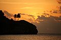
Flying Fish Cove in golden twilight
See also
 In Spanish: Isla de Navidad para niños
