
Image: Comparison azimuthal projections

Size of this PNG preview of this SVG file: 512 × 171 pixels. Other resolution: 320 × 107 pixels.
Original image (SVG file, nominally 512 × 171 pixels, file size: 113 KB)
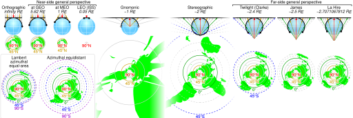
Description: Comparison of some azimuthal projections of the world map based on information on http://www.progonos.com/furuti/MapProj/Normal/ProjAz/projAz.html . Values indicated are mean altitudes in terms of Earth radii. Circles denote latitudes of multiples of 15-degrees (dashed lines represent the southern hemisphere). In the SVG file, hover over a circle to show its latitude in a tooltip.
Title: Comparison azimuthal projections
Credit: Own work
Author: Cmglee
Usage Terms: Creative Commons Attribution-Share Alike 3.0
License: CC BY-SA 3.0
License Link: https://creativecommons.org/licenses/by-sa/3.0
Attribution Required?: Yes
Image usage
The following 2 pages link to this image:

All content from Kiddle encyclopedia articles (including the article images and facts) can be freely used under Attribution-ShareAlike license, unless stated otherwise.