
Image: Continental.coast.150AD.Germanic.peoples

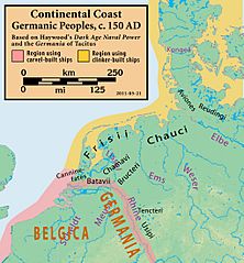
Description: Map of the modern coastline of the Netherlands, Germany, and Denmark, showing the Germanic peoples that lived there c. 150 AD and shipbuilding techniques they used (clinker-built and carvel-built)
Title: Continental.coast.150AD.Germanic.peoples
Credit: John Haywood's Dark Age Naval Power: Frankish & Anglo-Saxon Seafaring Activity (1999, ISBN 1-898281-43-2). The peoples are named in the text, with their locations shown on page 18. Also given in the text is the division between regions using clinker-built ships/boats and carvel-built ships/boats, with the dividing line at the Rhine River (which itself was in the carvel-built ship/boat-building region, from the Lower Rhine through the Middle Rhine). Use Tacitus' Germania for Canninefates placement. The topographic map is from DEMIS map server, appropriately tagged Template:Demis-pd prior to any modification. All modifications and annotations done by myself.
Author: my work
Permission: (see below)
Usage Terms: Creative Commons Attribution-Share Alike 3.0
License: CC BY-SA 3.0
License Link: https://creativecommons.org/licenses/by-sa/3.0
Attribution Required?: Yes
Image usage
The following page links to this image:
