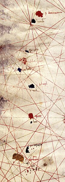
Image: Corbitis Atlas (Azores detail)

Size of this preview: 216 × 598 pixels. Other resolutions: 86 × 240 pixels | 1,063 × 2,941 pixels.
Original image (1,063 × 2,941 pixels, file size: 1.9 MB, MIME type: image/jpeg)
Description: 14th C. map of the Azores and Madeira islands, from the fourth sheet of the Corbitis Atlas, by an anonymous Venetian cartogapher, c.1385-1410. Currently held at Biblioteca Nazionale Marciana, Venice (Ms. It. VI 213). the Azores archipelago, is laid out vertically from north to south, and named as follows: y de corvi marini (Corvo), li conigi (Flores), sancto zorzi (São Jorge), y la ventura (Faial), li colonbi (Pico), y de brazil (Terceira), caprara (São Miguel) and lovo (Santa Maria). the Madeira archipelago, with the names y de legname (Madeira), porto santo (Porto Santo), ydesertas (Desertas). Further south are the y. salvaze (Savage Islands).
Usage Terms: Public domain
Image usage
The following page links to this image:

All content from Kiddle encyclopedia articles (including the article images and facts) can be freely used under Attribution-ShareAlike license, unless stated otherwise.
