History of the Azores facts for kids
This article tells the story of the history of the Azores. The Azores are a group of nine volcanic islands in the North Atlantic Ocean. They are about 1,400 kilometers (870 miles) west of Lisbon, Portugal. They are also about 1,500 kilometers (930 miles) northwest of Morocco and 1,930 kilometers (1,200 miles) southeast of Newfoundland, Canada.
Contents
Ancient Stories and Legends
For a very long time, people have told stories about islands in the Atlantic Ocean. Some of these were just legends, while others might have been based on real sightings.
Ancient Greek writers like Homer and Plato (who wrote about Atlantis) shared tales of amazing islands. Later, Roman writers like Pliny the Elder and Ptolemy even wrote about real islands, like the Canary Islands.
During the Middle Ages, new legends appeared. These came from different places:
- Irish stories about missionary voyages, like the tales of Saint Brendan.
- Norse (Viking) sagas about adventurers.
- Stories from people in Portugal and Spain, who lived closest to the Atlantic. Their sailors and fishers might have seen or even visited these islands.
Arab writers also shared stories. For example, there's the legend of the 9th-century sailor Khashkhash from Cordoba.
From all these stories, many mythical islands appeared on maps and in tales. These included Atlantis, Saint Brendan's Island, and Antillia. Even though they were just myths, people often believed they were real.
Some local stories in the Azores talked about strange discoveries before the Portuguese arrived. These included a mysterious statue and coins with ancient writing found on Corvo. There were also strange carvings on Terceira. However, these stories have not been proven true by scientists today.
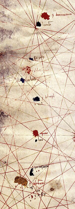
But there was some truth to the idea of islands in the Atlantic. Maps from the 1300s, like the Medici maps (1351) and the Catalan Atlas (1375), showed islands off the coast of Portugal. Some of these islands even had names similar to the modern Azores, like Corvo and São Jorge. This suggests that people in Europe knew about islands in the Atlantic by the late 1300s.
Early Discoveries and Structures
Mysterious Underground Structures
Between 2010 and 2011, scientists found hypogea on Corvo, Santa Maria, and Terceira. These are structures carved into the ground, possibly used for burials. They might suggest that people lived on the islands before the Portuguese arrived. Scientists are still studying these structures to find out how old they are and what they were used for.
Ancient Stone Structures
In 2015, new findings were made at the Grota do Medo site. Large stones were found that look like ancient megalithic buildings in Europe. Scientists used radiocarbon dating on a stone basin found there. They found organic material that was about 910 to 950 years old. This means these structures could be very old!
Were Vikings Here?
For a long time, people thought Portuguese explorers were the first humans to reach the Azores. However, new evidence suggests otherwise.
Scientists found a special compound in soil samples from between 700 and 850 CE. This compound comes from the poop of farm animals like sheep and cattle, which are not native to the islands. They also found signs of fires from this time, used to clear land for animals. Non-native ryegrass was also discovered.
Even more interesting, mice on the Azores have mitochondrial DNA that suggests they came from Northern Europe. This could mean they were brought by Norwegian Vikings.
However, some experts, like geographer Simon Connor, say it's not certain. He points out that mice from Scandinavia could have easily traveled on a ship from Portugal to the Azores due to widespread trade routes.
Exploring the Atlantic
Islands on Old Maps
The Azores started appearing on maps called portolan charts in the 1300s. These maps were used by sailors. The first map to show the Azores was the Medici Atlas in 1351. Other maps, like the Catalan Atlas (1375), also showed them.
On these old maps, the Azores usually appeared as nine islands in three groups, lined up from north to south. Some of the names on these old maps are similar to the names used today, like "San Zorzo" (São Jorge) and "Corvis Marinis" (Corvo).
It's a mystery how this information appeared on maps so early. It might have come from legends or from sailors who sighted the islands. It seems very likely that both the Azores and the Madeira islands were seen or discovered in the 1300s, even before their official discovery dates.
One idea is that the Azores were seen during a mapping trip in 1341 to the Canary Islands. This trip was supported by King Afonso IV of Portugal. Even if not officially discovered then, sailors might have spotted them from a distance on their way back.
Portuguese Exploration

In the late 1300s, many maps showed imaginary islands in the Atlantic. At this time, trade was growing between the Mediterranean and the Atlantic coast. Traders from Genoa, Florence, and Venice were very active. Religious groups also wanted to spread Christianity. This made Portugal, with its strong seafaring tradition, very important.
Prince Henry the Navigator (1394–1460) played a huge role. He used his own money to help the Portuguese crown. He paid for new ships, started naval schools, and encouraged new technologies for sailing. Prince Henry is often seen as the person who started modern exploration.
Prince Henry wanted to find a sea route to India and the legendary land of Prester John. This would help Portugal avoid the Muslim states in North Africa. He was also the leader of the Military Order of Christ, which supported exploration and settlement for these goals.
Prince Henry experimented with ships, tools, and maps. He helped develop techniques that made ocean travel possible. The Portuguese already knew about some Atlantic islands. But what was special was that Prince Henry "ordered [Portuguese navigators] to find the islands," rather than just letting them explore randomly.
The Re-discovery
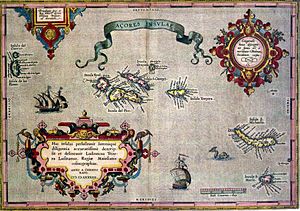
The exact date the Azores were officially "re-discovered" isn't perfectly clear. However, history books say that the islands of Santa Maria and São Miguel were first found by the navigator Diogo de Silves around 1427.
The name "Azores" itself has a few theories:
- Birds of Prey: The most common idea is that Portuguese sailors saw many birds of prey (like hawks or eagles) when they discovered the islands. However, the only bird of prey that lives there today is the common buzzard, which was brought later. Sailors might have mistaken other birds or used old names.
- Saint's Name: Another idea is that the discoverer, Gonçalo Velho Cabral, named them after Santa Maria of Açores, a patron saint in Portugal.
- Blue Islands: "Açores" might come from the Genovese or Florentine word azzurre or azzorre, meaning "blue." The islands' green plants can look blue from a distance. The Portuguese word for "blue" is azul.
After 1420, regular trips led by Gonçalo Velho Cabral and others explored west of Portugal. On August 15, 1432, sailors landed on Santa Maria. They named it after the Virgin Mary, whose Assumption Day is on that date.
The explorers quickly moved through the islands. They reached the western islands (Flores and Corvo) by about 1450. In the beginning, explorers would leave farm animals like sheep, goats, and chickens on the islands. This was to provide food for future settlers. There's also a record of a group of slaves being settled on São Miguel in the late 1430s.
Settling the Islands
The official settlement of the Azores began on Santa Maria. The first town was built in Baía dos Anjos, then moved to Vila do Porto. Settlers came from Portugal's Algarve and Alentejo regions. Later, people from Northern France and Flanders also arrived.
By 1440, other settlements grew on São Miguel, Terceira, Faial, and Pico. The islands had plenty of fresh water and rich volcanic soil, which made them easy to settle. They grew wheat to export, and also plants for dyes.
Christopher Columbus made an unplanned stop on Santa Maria during his first trip back from America. His ship, Niña, was caught in a storm. Columbus sent half his crew ashore to visit a church, as they had promised to do if they survived the storm. But the island's captain arrested them, thinking they were pirates! After two days, the captain released them, and Columbus continued his journey.
São Miguel was settled by 1444, mostly by people from Portugal. The settlers spread out along the coast where farming was good. The Azores' fertile land helped its population grow. The islands soon exported wheat to Portuguese soldiers in North Africa, and sugar cane and dyes to Flanders. Later, they grew and exported oranges to Britain. The area was also often attacked by pirates.
Ponta Delgada became the capital of São Miguel. The first capital, Vila Franca do Campo, was destroyed by an earthquake in 1522. Ponta Delgada became a city in 1546.
Terceira Island was the third island discovered, and its name means "Third Island." It was first settled in 1450. Graciosa Island was settled soon after by people from Terceira.
Flores Island was found in 1452 by Diogo de Teive. The island was first populated with sheep in 1475. Later, a Flemish man named Willem van der Haegen tried to settle Flores. He built homes, farmed wheat, and looked for metals. But because the island was so isolated, it was hard to export his crops. Van der Haegen left Flores in the late 1480s.
By 1504, more settlers came to Flores. The island became permanently populated around 1510 by people from different parts of Portugal. They grew grain and vegetables. Studies of DNA show that people from Flores have a strong genetic link to mainland Portugal.
Spanish Rule and Return to Portugal
The people of Terceira bravely fought against King Philip II of Spain when he became King of Portugal in 1580. Most of the Azores believed that António, Prior of Crato was the true king. They defeated the Spanish at the Battle of Salga in 1581.
In 1583, Philip tried again. He sent his Spanish fleet to the Azores. The Azores were the second-to-last part of the Portuguese empire to resist Philip's rule (only Macau resisted longer). The Azores returned to Portuguese control when the Iberian Union (when Spain and Portugal were united under one king) ended. This happened because the people attacked the Spanish soldiers in the Fortaleza de São João Baptista.
During the Spanish rule, the Azores were an important stop for Spanish ships. In December 1640, the Portuguese monarchy was restored, and the islands became Portuguese again.
Civil Wars and Changes
The civil war in Portugal in the 1820s also affected the Azores. In 1829, in Vila da Praia, the Liberals (who wanted more freedom) won against the Absolutists (who wanted the king to have all power). Terceira became the main base for the new Portuguese government.
In the late 1800s, the Azores helped Portugal's cod fishing industry grow again in Newfoundland. Azorean people who had moved to North America returned home and taught Portuguese fishers new techniques.
From 1836 to 1976, the Azores were divided into three districts, like those in mainland Portugal. This division was not based on the natural island groups. Instead, it was based on the three main cities:
- Angra included Terceira, São Jorge, and Graciosa. Its capital was Angra do Heroísmo on Terceira.
- Horta included Pico, Faial, Flores, and Corvo. Its capital was Horta on Faial.
- Ponta Delgada included São Miguel and Santa Maria. Its capital was Ponta Delgada on São Miguel.
The 20th Century
World War II
During World War II, in 1943, Portugal's leader Salazar allowed the British to use bases in the Azores. Before this, Portugal had only allowed German submarines to refuel there. This was a big change in the Battle of the Atlantic. It allowed the Allies to have air support in the middle of the Atlantic, which helped them find German submarines and protect ships.
In 1944, American forces built a small air base on Santa Maria. In 1945, a new base called Lajes Field was built on Terceira. This base is a joint effort between America and Portugal. Lajes Field has supported US and Portuguese military operations. During the Cold War, US Navy planes patrolled the North Atlantic for Soviet submarines. Lajes Field is still used today for refueling aircraft flying to Europe and the Middle East. It also has a small airport for commercial flights.
Carnation Revolution
In 1976, after the Carnation Revolution in 1974, the Azores became an Autonomous Region within Portugal. This meant they gained more self-rule, similar to Madeira. The old districts were removed, and a new regional constitution was put in place.
See also
 In Spanish: Historia de las Azores para niños
 | May Edward Chinn |
 | Rebecca Cole |
 | Alexa Canady |
 | Dorothy Lavinia Brown |


