
Image: CphUrbanAreaOnPoliticalMap2

Size of this preview: 662 × 600 pixels. Other resolutions: 265 × 240 pixels | 743 × 673 pixels.
Original image (743 × 673 pixels, file size: 53 KB, MIME type: image/png)
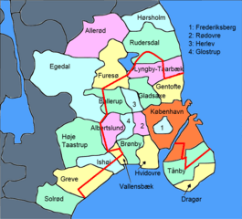
Description: Political map of Copenhagen and surroundings with urban area of the city of Copenhagen marked
Title: CphUrbanAreaOnPoliticalMap2
Credit: File:Central+suburban Copenhagen.PNG
Author: Kaare Dybvad
Usage Terms: Creative Commons Attribution-Share Alike 4.0
License: CC BY-SA 4.0
License Link: https://creativecommons.org/licenses/by-sa/4.0
Attribution Required?: Yes
Image usage
The following page links to this image:

All content from Kiddle encyclopedia articles (including the article images and facts) can be freely used under Attribution-ShareAlike license, unless stated otherwise.