
Image: Crozier-and-depot-knox-tn1886
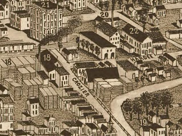
Description: Detail of an 1886 map of Knoxville, Tennessee, USA, showing what is now the Old City. "Crozier" is now Central Street, and Hardee roughly corresponds with what is now East Jackson. The street running across the top of the image (the with the "20") is Depot Street. Building #18 is the Burr and Terry Sash Factory. Building #19 is the Elridge Carriage Factory. Building #20 is Beach's Marble Works. Building #21 is the City Mills factory (later White Lily Foods). Building #22 is the Knoxville Foundry and Machine Shop. First Creek, which has since been diverted, runs across the lower right. Originally published as part of "Knoxville, Tenn., County Seat of Knox County, 1886."
Title: Crozier-and-depot-knox-tn1886
Credit: This map is available from the United States Library of Congress's Geography & Map Division under the digital ID g3964k.pm009000. This tag does not indicate the copyright status of the attached work. A normal copyright tag is still required. See Commons:Licensing for more information. العربية | čeština | Deutsch | English | español | فارسی | suomi | français | magyar | italiano | македонски | മലയാളം | Nederlands | polski | português | русский | slovenčina | slovenščina | Türkçe | українська | 中文 | 中文(简体) | 中文(繁體) | +/−
Author: H. Wellge (drawing); Beck and Pauli (lithograph)
Usage Terms: Public domain
License: Public domain
Attribution Required?: No
Image usage
The following page links to this image:
